
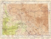
1945 U.S.C.G.S. Aeronautical Chart of Arizona

This item has been sold.
AAF Aeronautical Chart Gila River 405.
A visual summary of military bases established in Arizona during World War II.
- Digital Map Information
- Suitable for large format printing
- Full resolution TIFF file
- ICC color profile embedded
- Delivered instantly via download link
A visual summary of military bases established in Arizona during World War II.
This is a 1945 U.S. Coast and Geodetic Survey aeronautical chart of Arizona. Published near the end of World War II, the map highlights numerous Army, Army Air Force, Navy, and Marine airfields and other installations across the state. The sheer number of bases underscores how much the country dedicated to winning the war and training the soldiers and pilots needed to do so.A Closer Look
Depicting from Lake Mead and the Grand Canyon to just south of Tucson, this map illustrates most of Arizona and the extreme southern portion of Nevada around Boulder City. As a U.S. Army Air Force aeronautical chart, this map was created for military pilots. Circles mark both military and civilian airfields. The percentage of the circle that is filled in indicates the length of the longest runway at each location. Some of these airfields, such as those at Phoenix, Tucson, and Kingman, have become civilian airfields after the war. Others, such as Yuma, Luke, and Williams, are still in use today by the U.S. military. Diagonal lines outline ‘Danger Areas’ throughout the state, highlighting areas where even military pilots should not fly. None are explicitly identified, but some easily understood with the benefit of the nearly 80 years since the end of the war. The large area in the southwestern portion of the map is almost certainly the Desert Training Center, established in 1942 to teach Army and Army Air Force personnel to live and fight in the desert.Arizona During World War II
Arizona hosted numerous, Army, Army Air Force, Navy, and Marine bases during World War II, including part of the Desert Training Center. Several flight training schools were established for Army, Navy, and Marine pilots, along with a handful of gunnery ranges. Two Japanese internment camps were established in Arizona as was an Italian prisoner of war camp.Thunderbird Field No. 1
Thunderbird Field No.1 (which is marked here) was established in 1939 in Glendale, Arizona, and was a contract primary flight training base for Allied pilots. James Stewart, the famous Hollywood actor, helped establish the field, which was officially designated Thunderbird Field No. 1 after Thunderbird Field No. 2 was established on June 22, 1942. The Hollywood movie Thunder Birds was filmed at the field in 1942. Thunderbird Field was declared surplus in 1946 and was closed at some point within the next year.Publication History and Census
This map was created and published by the U.S. Coast and Geodetic Survey in March 1945. This map is not cataloged in OCLC, and it is scarce on the private market.Cartographer
The Office of the Coast Survey (1807 - present), founded in 1807 by President Thomas Jefferson and Secretary of the Treasury Albert Gallatin, is the oldest scientific organization in the U.S. Federal Government. Jefferson created the "Survey of the Coast," as it was then called, to produce accurate navigational charts of the new nation's coasts and harbors. The first two superintendents defined the spirit of the Coast Survey. The Coast Survey's first superintendent was Swiss immigrant and West Point mathematics professor Ferdinand Hassler. Under Hassler's direction, from 1816 to 1843, the Coast Survey established its ideological and scientific foundations. These included the use of the most advanced techniques and most sophisticated equipment, along with unstinting attention to detail. Hassler devised a labor-intensive triangulation system that divided the entire coast into a series of enormous triangles. These were then subdivided into smaller triangulation units, which were individually surveyed. No one had ever attempted this exacting technique on such a massive scale. As a result, Hassler and the Coast Survey under his leadership earned a reputation for uncompromising dedication to accuracy and excellence. Unfortunately, despite being a masterful surveyor, Hassler was abrasive and politically unpopular, and Congress cut funding for the Coast Survey twice. Nonetheless, Hassler led the Coast Survey until his death in 1843, when Alexander Dallas Bache, Benjamin Franklin's great-grandson, took the helm. Bache was fully dedicated to the principles established by Hassler, but proved more politically astute and successfully lobbied Congress to fund the endeavor generously. Under A. D. Bache's leadership, the Coast Survey completed its most important work. During his long tenure with the Coast Survey, from 1843 to 1865, Bache steadfastly advocated American science and navigation and, in fact, founded the American Academy of Sciences. Benjamin Pierce succeeded Bache and ran the Survey from 1867 to 1874. Pierce was succeeded by Carlile Pollock Patterson, Superintendent from 1874 to 1881. In 1878, under Patterson's superintendence, the U.S. Coast Survey was reorganized as the U.S. Coast and Geodetic Survey (USCGS) to accommodate both topographic and nautical surveys. Today, the Coast Survey is part of the National Oceanic and Atmospheric Administration (NOAA) as the National Geodetic Survey. Further Details...
Condition
Excellent. Light wear along original fold lines.