1935 U.S. Forest Service and National Park Service Wall Map of Glacier National Park, Montana
GlacierNP-forestnationalparkservice-1935$400.00
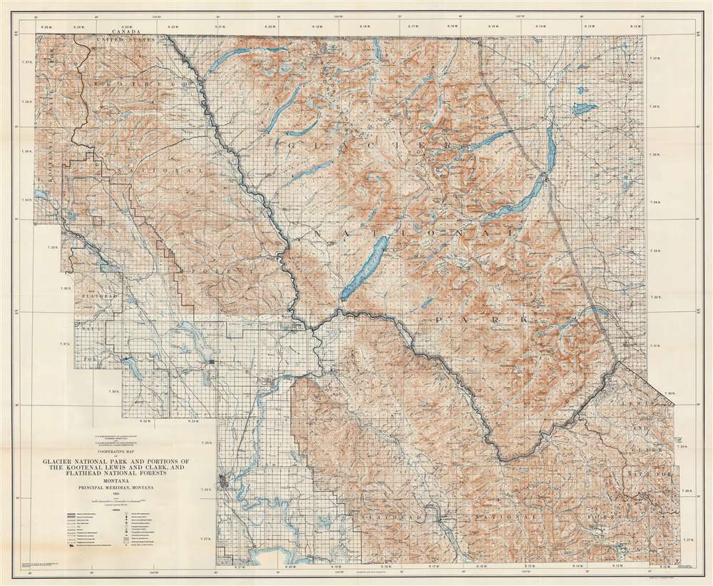


Title
Cooperative Map of Glacier National Park and Portions of the Kootenai, Lewis and Clark, and Flathead National Forests.
1935 (dated) 36.25 x 44 in (92.075 x 111.76 cm) 1 : 126720
1935 (dated) 36.25 x 44 in (92.075 x 111.76 cm) 1 : 126720
Description
This is a 1935 U.S. Forest Service and National Park Service wall map of Glacier National Park and its immediate surroundings. Glaciers, mountain peaks, waterfalls, and other landmarks are identified throughout Glacier National Park and the surrounding forests. Campgrounds are marked by small tent icons and labeled. Contour lines present the park's impressive topography and mountain lakes and rivers are illustrated.
Glacier National Park
Glacier National Park, established May 11, 1910, is an American national park in northwestern Montana on the U.S.-Canada border. Encompassing over one million acres, Glacier National Park includes part of two sub-ranges of the Rocky Mountains and is home to hundreds of species of animals. 130 named lakes are within the park's borders. The park also borders Waterton Lakes National Park in Canada which led to the establishment of Waterton-Glacier International Peace Park in 1932. The Peace Park was named a UNESCO World Heritage Site in 1995.Publication History and Census
This map was jointly compiled and published by the U.S. Forest Service and the National Park Service in 1935. We note four examples cataloged in OCLC which are part of the collections at the University of Idaho, Washington State University, Reed College, and the University of California Berkeley. An earlier edition was published in 1929. Only one example of the 1929 edition is cataloged in OCLC, and it is part of the collection at the University of Montana.CartographerS
The United States Forest Service (February 1, 1905 - Present) is an American government agency that is part of the U.S. Department of Agriculture. Managing about twenty five percent of federal lands, the Forest Service administers 154 national forests and twenty national grasslands, a total of 193 million acres. It is also the only federal land management agency that is not part of the U.S. Department of the Interior. More by this mapmaker...
The National Park Service (August 25, 1916 - Present) is a United States government agency tasked with managing all national parks, most national monuments, and other historical, recreational, and natural properties. Part of the U.S. Department of the Interior, the Service oversaw 423 units in 2020, sixty-three of which were national parks, and employed over 12,500 people. Learn More...
Condition
Very good. Light wear along original fold lines. Closed minor margin tears professionally repaired on verso.
References
OCLC 38112305.