This item has been sold, but you can get on the Waitlist to be notified if another example becomes available, or purchase a digital scan.
1900 Manuscript Map of Globe Mine, Trinity County, California
GlobeMineTrinityCountyCA-unknown-1900$500.00


Title
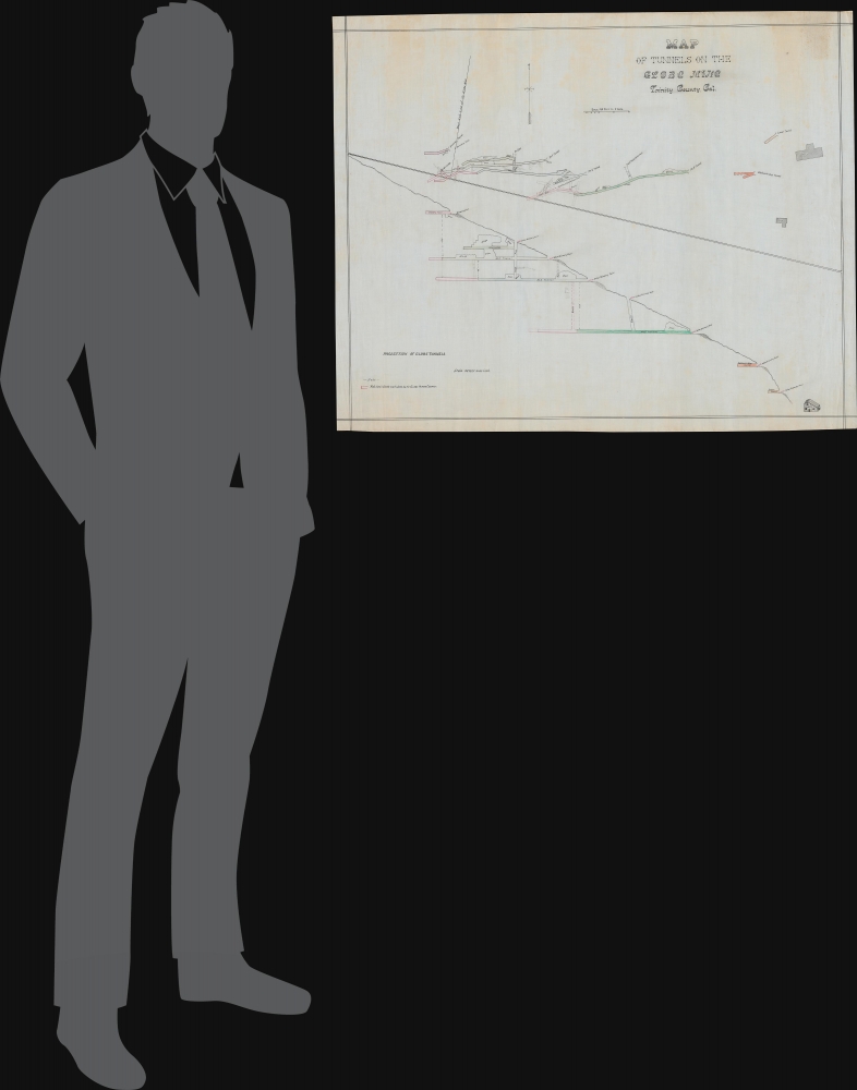
Map of Tunnels on the Globe Mine Trinity County, Cal.
1900 (undated) 28 x 35 in (71.12 x 88.9 cm) 1 : 480
1900 (undated) 28 x 35 in (71.12 x 88.9 cm) 1 : 480
Description
This is a unique c. 1900 manuscript map of the Globe Mine in Trinity County, California, an important site in the transition of gold mining in California from placer mining to deep underground mining.
The mine was operated by the Globe Mining Company; detailed information on this company is difficult to find, and there may have been several contemporaneous operations with this name with mines in Michigan, South Dakota, Washington, and California. The mine depicted here was most likely a California venture launched by the Seattle and Spokane-based Globe Mining Co.
The location of the Globe Mine is not far (about 8 miles) from Lake Trinity, a reservoir created in the 1950s with the construction of the Trinity Dam that is used to irrigate productive agricultural lands further south. The former mine, the reservoir, and the surrounding lands are now part of the Shasta-Trinity National Forest.
A Closer Look
The sheet is divided in two, with the top providing an overhead view of the mine tunnels and facilities (blacksmith, mill, house). Notes in pen and pencil, the latter seemingly added later, indicate existing and planned junctions, stopes, winzes and raises, cross-cuts, and other features. The bottom half of the sheet is a 'projection' or profile of the mountainside, recording the elevation of the various tunnels and facilities, from Discovery Point down to the mill some 500 feet below, and the connections between them.The Globe Mine
The Globe Mine, located in Trinity County, California, is intimately linked to the California Gold Rush and the subsequent rise of hard rock mining in the 19th and early 20th centuries. Situated in the historic Weaverville mining district, the mine opened in 1889. It was one of many that capitalized on the region's rich quartz veins, which contained gold, galena, and other valuable minerals. Unlike the early placer mining operations that dominated the 1850s, the Globe Mine represented the transition to deep underground mining, requiring more advanced techniques and equipment. By the late 19th century, it was a well-established operation, contributing significantly to the local economy and attracting miners seeking long-term employment. With fluctuating gold prices and stricter regulations, mining activity declined in the mid-20th century.The mine was operated by the Globe Mining Company; detailed information on this company is difficult to find, and there may have been several contemporaneous operations with this name with mines in Michigan, South Dakota, Washington, and California. The mine depicted here was most likely a California venture launched by the Seattle and Spokane-based Globe Mining Co.
The location of the Globe Mine is not far (about 8 miles) from Lake Trinity, a reservoir created in the 1950s with the construction of the Trinity Dam that is used to irrigate productive agricultural lands further south. The former mine, the reservoir, and the surrounding lands are now part of the Shasta-Trinity National Forest.
Publication History and Census
This map was drawn by an unknown surveyor around the year 1900. As a manuscript map, it is an entirely unique production.Condition
Very good. Some discoloration upper quadrants. On waxed surveyor's linen.