
1947 Lucas Company Map of Gloucester and Rockport, Massachusetts and Environs


Gloucester and Rockport Mass.
Stunning Cape Ann.
$275.00
Choose a Collection:
- Digital Map Information
- Suitable for large format printing
- Full resolution TIFF file
- ICC color profile embedded
- Delivered instantly via download link
This Item
Enquire
Stunning Cape Ann.
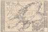
This is a 1947 Lucas Company map of Gloucester and Rockport, Massachusetts. Depicting from Ipswich Bay south to Eastern Point and from Haskell's Pond east to Gap Head, Gloucester and Rockport are illustrated in detail. Plenty of coastal detail is provided, with coves, necks, bays, and other features all identified. Numerous beaches are labeled as well. Streets are labeled throughout the region, along with ponds, reservoirs, and the Annisquam River. A dashed black and white line traces the route of the Gloucester Branch of the Boston and Maine Railroad. An inset in the lower right corner details Gloucester, providing a much more comprehensive depiction of the town. An alphabetical street guide of Gloucester occupies the left side of the sheet and continues onto the right side where schools, churches, important buildings, and points of interest are listed. A similar street guide to Rockport also occupies the right side and includes a list of schools, churches, and important buildings in town as well.Publication History and Census
This map was created and published by the Lucas Company in 1947. Earlier editions were published, per the map, beginning in 1937 with revisions appearing in 1941 and 1944. We note three examples of the 1947 edition cataloged in OCLC, which are part of the institutional collections at the Library of Congress, the Peabody Essex Museum, and the Osher Map Library at the University of Southern Maine.Condition
Very good. Exhibits light wear along original fold lines. Verso repairs to fold separations. Exhibits old cellophane tape residue on verso.
References
OCLC 5443985.