
1878 Assa Castel Branco Map of Goa, India


This item has been sold.
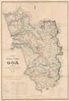
Carta do Territorio Portuguez de Goa Correcta port jose Frederico d'Assa Castel Branco.
Goan economic revival.
- Digital Map Information
- Suitable for large format printing
- Full resolution TIFF file
- ICC color profile embedded
- Delivered instantly via download link
Goan economic revival.
This is an impressive large-scale 1878 first-edition map of Goa by Goa-born military engineer José Frederico d'Assa Castel-Branco. It represents a revolution in the cartographic knowledge of Goa and the finest trigonometrical map of Goa to appear in the 19th century. It was made in response to the signing of the Anglo-Portuguese Treaty of 1878, a major economic treaty that saw massive infrastructure development and the revitalization of the Goan economy after nearly 100 years of isolation and stagnation.The Anglo-Portuguese Treaty of 1878
This map closely follows the Anglo-Portuguese Treaty of 1878. The commercial treaty was designed to alleviate nearly a century of Goan economic stagnation - largely resulting from local bureaucratic inefficiencies, trade isolation, and the general decline of Portuguese commercial and imperial might. According to the agreement, the British Raj would finance a series of major infrastructure projects in Goa in exchange for vast trade concessions and a salt monopoly.The cornerstone of the project was the development of the natural harbor of Mormugâo into a major modern shipping hub connected to British India via a new railroad, the West of India Portuguese Railway (Mormugâo Railroad). The British would thus gain a new port connecting its colonies in Deccan to an easy-access global port, and the Goans would benefit from increased mobility, taxes, and general trade.
This map represents preliminary work following the treaty to establish a general triangulation for the colony and act as a baseline for any further infrastructure development. Subsequent editions followed. We are aware of at least one later edition issued in 1890 following the 1887 inauguration of the completed Mormugâo Railroad - Port link.
Publication History and Census
This map was drawn by José Frederico d'Assa Castel-Branco in 1878 - representing the first edition. It was commissioned in Goa by A. Mathais Gomes and Filhos, and published in Paris by A. Chaix. The map is today quite scarce. At least one latter edition was issued in 1890 with significant updates. We note institutional holdings at the British Library, New York University, the Bibliothèque interuniversitaire de la Sorbonne, the Bibliothèque nationale de France, the Universiteitsbibliotheek Leiden, the Biblioteca Nacional de Portugal, and the Staatsbibliothek zu Berlin. We see one example each of the 1878 and 1890 editions in trade history.Cartographers
José Frederico d'Assa Castel-Branco (March 5, 1836 - March 5, 1912) was a Goa-born Portuguese military engineer active in Goa in the late 19th century. He studied at the Escola Mathemática e Militar de Goa from 1850, after which he joined the Goan-Portuguese Army. Roughly 10 years later, around 1860, his engineering skills led to his assignment to the State Engineering Department of Portuguese India. His work transitioned from military to civil engineering. In 1871, he designed the first set of 6 adhesive postal stamps for Portuguese India, labeled SERVIÇO POSTAL, also known as 'SELOS NATIVOS' (Native Stamps). The stamps gained world fame because Portuguese India was the only Portuguese colony to produce its first postage stamps locally. Following the Anglo-Portuguese Treaty of 1878, he began compiling his surveys and the work of others into a large and impressive map of Goa - the finest yet produced. In 1879, he became the Vice-Director of Public Works and Deputy Director of the State Engineers. In 1887, he began teaching engineering at the Escola Profissional and the Liceu de Goa. In 1888, he was promoted to Director General of Public Works of Portuguese India. He retired as a General in 1901, but remained active in the Office of Public Works until about 1905. Further Details...
Imprimerie Chaix (1845 - 1965) was a French publishing firm based at 20 Rue Bergère in Paris. They are best known for printing and publishing Belle Époque posters, including the celebrated Les Maîtres de l'Affiche. Les Maîtres de l'Affiche was a highly influential art publication featuring the Belle Époque commercial posters. Based upon a monthly subscription system, members received four prints each month over a five year period, resulting in 240 images along with 16 bonus images. Further Details...
Condition
Very good. Wear along original fold lines. Verso repairs to fold separations and at some fold intersections. Closed tear extending 1.25 inch in printed area from central fold intersection professionally repaired on verso.
References
OCLC 557565749, 944323348. Biblioteca Nacional de Portugal: C.C.d. 147 R.