This item has been sold, but you can get on the Waitlist to be notified if another example becomes available, or purchase a digital scan.
1852 Phillip Map of the Gold Fields of New South Wales, Australia
GoldFieldsNewSouthWales2-phillip-1852$750.00

Title
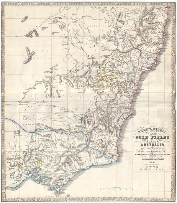
Philip's New Map of the Gold Fields of Australia comprising all the recent discoveries of Mr. Hargraves, Mr. Hunter, Revd. W. Clark and others in the auriferous districts.
1852 (dated) 24.25 x 19.5 in (61.595 x 49.53 cm) 1 : 1800000
1852 (dated) 24.25 x 19.5 in (61.595 x 49.53 cm) 1 : 1800000
Description
A remarkable 1852 George Philip map of the Gold Discoveries in New South Sales, Victoria, Australia. The map, in original color, covers the southeast part of the Australian Continent from Clarence to Port Phillip and Wilson Promontory. Gold regions are highlighted in yellow, among them the discoveries at Bathurst, Turon River, Ophir, Summerhill, Tamworth, Goulbourn, Quenbeyan and Araluen.
Gold was known to be present in Australia prior to 1851, but the intentional suppression of this information by the colonial government of New South Wales prevented all-out gold rushes. When gold was discovered at Sutter's Mill, California, in 1848, causing the California Gold Rush, countless Australians migrated in search of their fortunes. Desirous of maintaining their dwindling work force, the colonial governors rethought thir position, and sought approval from the Colonial Office in England to allow the exploitation of the mineral resources and also offered rewards for the finding of payable gold. This led to the first major Australian gold rush when prospector Edward Hargraves discovered gold at Ophir, near Orange. A series of subsequent discoveries followed, transforming the Australian economy and leading to a rush of new immigration.
This map appeared in at least three states. The first, seen here, was separately issued shortly after the major gold discoveries of May, 1851. A second edition with a modified title was issued to accompany John Capper's 1853 Emigrant's Guide to Australia. Another edition was published separately by George Philip and Son and features different borders an updated geography. All editions are exceedingly rare.
Cartographer
George Philip (1800 - 1882) was a map publisher and cartographer active in the mid to late-19th century. Philip was born into a Calvinst family in Huntly, Aberdeenshire, Scotland. Around 1819 he apprenticed himself to William Grapel, a Liverpool printer and bookseller. Fifteen years later, in 1834, Philip founded his own Liverpool book and map firm. Philip's earliest cartographic ventures were mostly educational material issued in tandem with John Bartholomew Sr., August Petermann, and William Hughes. In 1848, Philip admitted his son, George Philip Jr. (1823 - 1902) into the firm, renaming it George Philip and Son Ltd. George Philip Jr. ran the firm until his death in 1902, by which time it had developed into a major publishing concern. His successors established the London Geographical Institute, a factory where they embraced modern printing techniques to produce thousands of economical and high quality maps. In April 1988, George Philip & Son was acquired by Octopus Publishing, a branch of Reed International. Nonetheless, today the firm trades and publishes to this day as George Philip and Son. More by this mapmaker...
Condition
Good. Margin reinforcement. Trimmed to neatline all around.
References
OCLC 225681203.