This item has been sold, but you can get on the Waitlist to be notified if another example becomes available, or purchase a digital scan.
1853 Phillip Map of the Gold Fields of New South Wales, Australia
GoldFiledsNewSouthWales-phillip-1853$1,000.00

Title
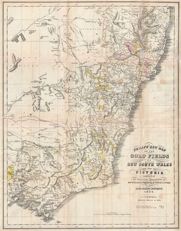
Philip's New Map of the Gold Fields of Australia comprising all the recent discoveries of Rev. W.B. Clarke, Mr. Hargraves, Mr. Hunter and others in the auriferous districts.
1853 (dated) 24.25 x 19.5 in (61.595 x 49.53 cm) 1 : 1800000
1853 (dated) 24.25 x 19.5 in (61.595 x 49.53 cm) 1 : 1800000
Description
A remarkable 1853 map of the Gold Discoveries in New South Sales, Victoria, Australia. The map, in original color, covers the southeast part of the Australian Continent from Clarence to Pot Phillip and Wilson Promontory. The map was published early in the history of Victoria gold rushes with the most prominent gold fields are shown appearing in New South Sales. These include the discoveries at Bathurst, Turon River, Ophir, Summerhill, Tamworth, Goulbourn, Quenbeyan and Araluen.
This map appeared in at least two states. The first, seen here, accompanied John Capper's 1853 Emigrant's Guide to Australia. Another edition was published separately by George Philip and Son and features different borders an updated geography. Although extremely rare today, the Capper Emigrant's Guide was popular in its day, going through at least three editions between 1853 and 1856.
This map appeared in at least two states. The first, seen here, accompanied John Capper's 1853 Emigrant's Guide to Australia. Another edition was published separately by George Philip and Son and features different borders an updated geography. Although extremely rare today, the Capper Emigrant's Guide was popular in its day, going through at least three editions between 1853 and 1856.
Cartographer
George Philip (1800 - 1882) was a map publisher and cartographer active in the mid to late-19th century. Philip was born into a Calvinst family in Huntly, Aberdeenshire, Scotland. Around 1819 he apprenticed himself to William Grapel, a Liverpool printer and bookseller. Fifteen years later, in 1834, Philip founded his own Liverpool book and map firm. Philip's earliest cartographic ventures were mostly educational material issued in tandem with John Bartholomew Sr., August Petermann, and William Hughes. In 1848, Philip admitted his son, George Philip Jr. (1823 - 1902) into the firm, renaming it George Philip and Son Ltd. George Philip Jr. ran the firm until his death in 1902, by which time it had developed into a major publishing concern. His successors established the London Geographical Institute, a factory where they embraced modern printing techniques to produce thousands of economical and high quality maps. In April 1988, George Philip & Son was acquired by Octopus Publishing, a branch of Reed International. Nonetheless, today the firm trades and publishes to this day as George Philip and Son. More by this mapmaker...
Source
Capper, J., The Emigrant's Guide to Australia, (Liverpool: George Philip) 1853.
Condition
Good. Some repairs in the upper right. Backed on archival tissue. Right and bottom margins extended.
References
OCLC 224613638.