This item has been sold, but you can get on the Waitlist to be notified if another example becomes available, or purchase a digital scan.
1849 Ensign and Thayer Boradside Map of the California Gold Rush
GoldRegionsCalifornia-ensignthayer-1849$3,500.00

Title
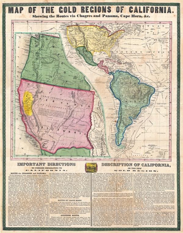
Map of the Gold Regions of California. Showing the Routes via Chagres and Panama, Cape Horn, & c.
1849 (dated) 24 x 19 in (60.96 x 48.26 cm)
1849 (dated) 24 x 19 in (60.96 x 48.26 cm)
Description
A rare and remarkable example of Ensign and Thayer's 1849 promotional broadside map illustrating routes to and from the California Gold Fields. 'Forty-Niners' traveling across the continent to California faced a daunting and dangerous voyage. Moreover, the California Gold Rush was exactly that, a rush, being, very much an 'early bird gets the worm' situation. Prospectors were keenly aware that the best gold lands were quickly being claimed and so had to balance dangers, time, and expense with the risk of missing out on the strike of a lifetime.
Ensign and Thayer's broadside map illustrates the three primary routes to California and offers copious original text and commentary on the voyage:
Ensign and Thayer's broadside map illustrates the three primary routes to California and offers copious original text and commentary on the voyage:
- Cape Horn Route – this route, by ship around South America, offers advantages 'as far as cost and facilities are concerned,' though 'the loss of time balances the difference in the price of passage.'
- Veracruz Route – this route, through the Mexican port of Veracruz, overland to Acapulco, then by ship to California is promoted as the 'cheapest, quickest, and safest' except for the fact that to 'prevent the danger of being attacked by robbers through Mexico, persons should go in parties of 40 to 50 or more.'
- Panama Route – this route, which entails taking a ship to the river port of Chagres, little more than a village, then traveling upriver and over the Isthmus of Panama, to the Pacific where passage may be had to California, seems quite popular though the author warns against it as dangerous and impractical due to overcrowding, inhospitable climate, risk of robbery, inability to transport large amounts of equipment, and the absence of facilities.
The valley of the Sacramento is probably the most fertile on the Pacific, and GOLD, as well as the various productions of the earth, can be at all times obtained with the use of the plough, harrow and spade in the hands of an industrious man…. the region of California is possessed of vast mines of Gold and other metals, which will doubtless enrich this country, and be the means of populating that portion of it, to a degree not heretofore anticipated. Such is California—the richest, most picturesque and beautiful region, for its extent, upon the face of the earth. Such is the El Dorado of the Gold mines; and such is the great acquisition of the late war with Mexico.The document itself features two maps. A large map of North and South America detailing the possible routes to California, and a large inset map offering a detail of the California gold region. The large America map, in addition to offering three practical routes to the gold fields, also details the routes if important explorers such as Wilkes, Cook, Vancouver, Perouse, and others – no doubt an attempt to associate the prospective prospector with the great explorers of history. The large inset of the Gold Region, details all of Upper California and parts of Oregon according to the 1848 Treaty of Guadalupe Hidalgo. The gold fields of the Sacramento Valley themselves are highlighted in bright yellow – suggestive of the wealth to be found there.
This is some confusion regarding the source of this map. Wheat and others have noted that examples of this broadside are occasionally associated with copies of Thomas J. Farnham's Life, Adventures, and Travels in California, although it is unclear if the map was issued separately and attached to the book or actually published with the book. Another variant is known that features a larger, more decorative, border (Rumsey #3442). That edition bears the Ensign and Thayer imprint, which appears nowhere on the current edition. Both variants are undated, but an advertisement in the December 23, 1848 New York Tribune strongly suggests that it was published late that year.
An exceptional discovery and an important Gold Rush document.
CartographerS
Edward Hooker Ensign (August 18, 1818 - July 10, 1871) was an American map and print publisher based in New York during the middle part of the 19th century. Edward was born in West Hartland, Connecticut. Little is known of Ensign's training but he may have inherited his business from his father, Timothy Ensign (1795 - 1859), who was a map publisher active in New York. Ensign seems to have had a flair for partnerships and variously published with Humphrey Phelps (1799 - 1875), Horace Thayer, Thomas C. Fanning (1805 - 1873) and Erastus C. Bridgman (1817 - 1870), among others. His various imprints include 'Phelps and Ensign' (1841-1844), 'T. and E. H. Ensign' (1844-1848), 'Ensign and Thayer' (1849), 'Ensign, Thayer, and Company' (1850-1851), 'Horace Thayer and Company' (1852), and 'Ensign, Bridgman and Fanning' (1854-1863). It appears that father and son worked together for some time as well, publishing as either 'T. and E. H. Ensign' or 'Ensigns'. At least some of these companies maintained offices in both Buffalo and New York City. More by this mapmaker...
Horace Thayer (June 29, 1811 - March 15, 1875) was a New York based publisher and lithographer active in New York City and Buffalo, New York, during the middle part of the 19th century. Thayer's publications focused on travel guides, wall, and pocket maps - many of which were based on the works of other American cartographers including J. H. Colton and S. A. Mitchell. In the 1840s, he partnered with the Hartford, Connecticut publisher Timothy Ensign (1795 - 1849) and later his son, Edward Hooker Ensign (1818 - 1871). According to map historian Walter Ristow, J. H. Colton's older son, George Washington Colton, partnered with Thayer in the late 1850s and early 1860s, possibly in order to learn Thayer's lithography techniques. Certainly a number of maps emerged bearing a 'Thayer and Colton' imprint. At various points Thayer also published with other prominent publishers and printmakers, publishing as Kelloggs and Thayer (1846 - 1847), Ensigns and Thayer (1848), Ensign and Thayer (1849 - 1850), and Ensign, Thayer, and Company (1850 - 1851), Phelps and Watson (1859), and Thayer and Colton (1859-186?). Thayer seems to have moved frequently and had offices at 50 Ann Street, 156 William Street, and at 18 Beekman Street, all in New York City. Learn More...
Condition
Very good. Original folds. Bright color. Blank on verso. Some age toning
References
Rumsey 4683.000. Wheat, C. I., Maps of the California Gold Region, 1848 – 1857, #85. Wheat, C. I., Mapping of the Transmississippi West, 1540 – 1861, #609