1754 Bellin Map and Chart of the Gulf of Guinea
GolfedeGuinee-bellin-1754$200.00

Title
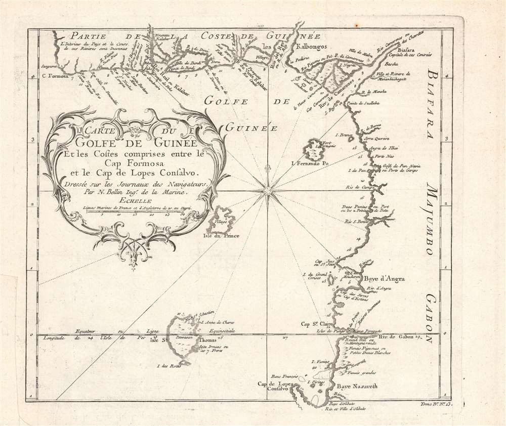
Carte du golfe de Guinée et les costes comprises entre le cap Formosa et le cap de Lopes Goncalvo.
1754 (undated) 9.5 x 11 in (24.13 x 27.94 cm) 1 : 2900000
1754 (undated) 9.5 x 11 in (24.13 x 27.94 cm) 1 : 2900000
Description
This is a c. 1754 map and chart of the Gulf of Guinea by Jacques-Nicolas Bellin that appeared in the Abbé Prévost's Histoire Generale Des Voyages. It notes a range of maritime and terrestrial features, especially rivers flowing from the African interior into the gulf.
The mid-late 18th century saw the height of the Transatlantic Slave Trade and the lands shown here were one of the main sources of slaves bound for the New World. For example, the banks of the Calabar (Kalabar) River at top became a major site for slave trading, as European traders, especially British traders, developed relationships with the Efik people based there. The majority of those captured as slaves and then passed on to European traders on the Calabar River and elsewhere along the Bight of Biafra were Igbo.
A Closer Look
Coverage includes the Gulf of Guinea and the West African coast from the Niger River Delta, on 'Cape Formosa' in present day Nigeria, to Cape Lopez, in present-day Gabon, a stretch of coastline sometimes called the Bight of Biafra or the Bight of Bonny. Bioko Island, here as Fernando Po, is prominent at center towards top-right. The size of the islands of São Tomé and Príncipe are exaggerated, likely due to the islands' importance for trade and navigation. Soundings are provided along the coast and Bellin was especially diligent in noting the names of rivers flowing into the gulf, though he admits at top-left (the Niger River Delta) that 'the interior of this country and the course of these rivers are unknown.' Some coastal settlements, forts, and mountains are also noted.The mid-late 18th century saw the height of the Transatlantic Slave Trade and the lands shown here were one of the main sources of slaves bound for the New World. For example, the banks of the Calabar (Kalabar) River at top became a major site for slave trading, as European traders, especially British traders, developed relationships with the Efik people based there. The majority of those captured as slaves and then passed on to European traders on the Calabar River and elsewhere along the Bight of Biafra were Igbo.
Publication History and Census
This map was made by Jacques-Nicolas Bellin and appeared as Plate No. 13 in Tome IV of the Abbé Prévost's Histoire Generale Des Voyages… As it is undated and the Histoire Generale Des Voyages… went through several editions, dating it is difficult. Regardless of date assigned at cataloging, the map is only listed independently among the holdings of the New York Public Library and the Bibliothèque nationale de France, while the Abbé Prévost's entire work (which may or may not include the map) is more widely distributed.CartographerS
Jacques-Nicolas Bellin (1703 - March 21, 1772) was one of the most important cartographers of the 18th century. With a career spanning some 50 years, Bellin is best understood as geographe de cabinet and transitional mapmaker spanning the gap between 18th and early-19th century cartographic styles. His long career as Hydrographer and Ingénieur Hydrographe at the French Dépôt des cartes et plans de la Marine resulted in hundreds of high quality nautical charts of practically everywhere in the world. A true child of the Enlightenment Era, Bellin's work focuses on function and accuracy tending in the process to be less decorative than the earlier 17th and 18th century cartographic work. Unlike many of his contemporaries, Bellin was always careful to cite his references and his scholarly corpus consists of over 1400 articles on geography prepared for Diderot's Encyclopedie. Bellin, despite his extraordinary success, may not have enjoyed his work, which is described as "long, unpleasant, and hard." In addition to numerous maps and charts published during his lifetime, many of Bellin's maps were updated (or not) and published posthumously. He was succeeded as Ingénieur Hydrographe by his student, also a prolific and influential cartographer, Rigobert Bonne. More by this mapmaker...
Antoine François Prévost d'Exiles (April 1, 1697 – November 25, 1763), usually known the Abbé Prévost, was a French author and novelist. Having had difficulty in his youth determining a preference for life in the military or life among the Jesuits, he eventually wound up with the Benedictines, with whom he took vows. Despite his taking the vows, the vows evidently did not take with him: in 1728 he abandoned his abbey and fled to London. Naturally, he became a writer. In this he was prolific, both producing his own work and translations of others. Beginning in 1726, he published the first volume of his Histoire générale des voyages, which he worked on for the remained of his life and which was completed by his associates after his death, stretching to 25 volumes. Learn More...
Source
Prévost, A., Histoire Générale des Voyages, ou Nouvelle Collection de Toutes les Relations de Voyages par Mer et par Terre..., (Paris: Didot) 1746 - 1759, Supplements 1761 - 1801.
Prévost's Histoire Générale des Voyages is a 15-volume compendium of travel literature initiated by Antoine François Prévost (Provost; 1697 - 1763) in 1746, intended as a universal history of exploration and geography. The initial publication, compiled from 1746 to 1759, spans 15 volumes and draws from a vast array of sources - travelers, explorers, missionaries, merchants, and diplomats - to present detailed narratives of significant global journeys. The work was initially published in Paris by Didot and offers ethnographic, political, religious, and natural observations about the peoples, cultures, flora, fauna, and geography. It is an ambitious attempt to organize knowledge about the world's diversity according to Enlightenment values, reflecting both scientific curiosity and imperial ideology. It functioned as both an informative reference and a literary work, influencing how European audiences understood and imagined distant lands. It proved extremely successful, and both reissues other publishers and pirate editions emerged, most notably Pierre de Hondt's 1747 Dutch edition and Jean-Franćois de la Harpe's 1780 abridged version. In addition to reissues of the original work, between 1768 and 1801, additional expanded volumes emerged, adding new voyages and histories. We have seen some sets with as many as 80 volumes. Over time, the Histoire générale des voyages became one of the most comprehensive and widely read travel collections of the 18th century, notable for blending factual reporting with the period's characteristic intellectual ambition.
Condition
Very good. One spot of discoloration in top margin towards right. Crease in bottom-left margin. Uncolored.
References
OCLC 494479315, 83554153.