1826 Depot de la Marine Nautical Chart or Map of Bay of Campeche, Mexico
GolfeMexiqueYucatan-depotmarine-1826$950.00


Title
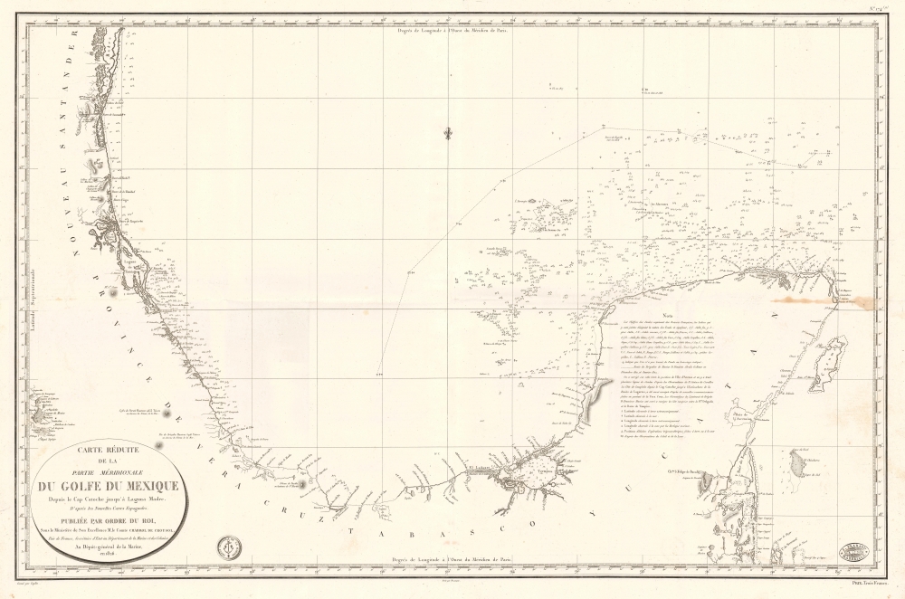
Carte Réduite de la Partie Méridionale du Golfe du Mexique Depuis le Cap Catoche jusqu'à Laguna Madre.
1826 (dated) 24 x 36 in (60.96 x 91.44 cm) 1 : 1500000
1826 (dated) 24 x 36 in (60.96 x 91.44 cm) 1 : 1500000
Description
This is an 1826 Dépôt de la Marine nautical map of the Gulf Coast of Mexico. The publication of this map in France reflects renewed and growing imperial interest in the New World, which culminated in the French Intervention in Mexico (1838 - 1839). This coast, and the Yucatan specifically, was the most important and wealthiest part of Mexico. The Yucatan was the only place in the world where sisal could be farmed from Henequen agave - the source of most of the world's nautical rope until the invention of synthetics.
A Closer Look
Based upon earlier Spanish charts, coverage embraces from the Laguna Madre south to the Yucatan Peninsula. Depth soundings appear haphazardly, disappearing along the stretch of coastline in the Bay of Campeche, except for the Laguna de Términos, underscoring just how poorly this region was mapped in the early 19th century.French Immigration to Mexico
French citizens began immigrating to Mexico as early as 1700 despite the Spanish ban on all foreign settlement in its New World colonies. French expatriates were allowed to settle in Mexico because of the Family Compact between France and Spain, signed by the two countries after 1700 when French King Charles X installed his grandson, Philip V, as King of Spain. Nonetheless, French immigrants to Mexico had to meet specific requirements, such as mastery of a unique and useful trade. French immigration to Mexico surged after 1821 when Mexico gained its independence. The French established colonies and encouraged settlement in Mexico, with an estimated 6,000 French expatriates living in Mexico by 1860. French citizens were increasingly unwelcome in Mexico and began complaining about their treatment. Many describe being unfairly taxed and forced to take out usurious loans, among other issues. French immigrants were, moreover, denied land ownership, a law that applied to all foreigners in Mexico. These complaints directly influenced the First French Intervention in Mexico in 1838 - 1839 and the subsequent French invasion of 1861 - 1867, when France installed Emperor Maximilian I in Mexico. Maximilian's short reign as Emperor of Mexico ended in front of a Mexican firing squad.Publication History and Census
This map was engraved by Jean-François Caplin with lettering by J.P. Besançon and published by the Dépôt de la Marine in 1826. An example is cataloged in OCLC and is part of the collection at the Bibliothèque Nationale de France.CartographerS
Dépôt des Cartes et Plans de la Marine (fl. 1720 - present), often called the Dépôt de Marine, was a French hydrographic mapping organization founded in 1720 under Charles-Hercule of Albert de Luynes (1674 - 1734). Much like the U.S. Coast Survey, the British Admiralty, and the Spanish Deposito Hydrografico, the Dépôt was initiated as a storehouse and distribution center of existing nautical and marine charts. Eventually the Dépôt initiated its own mapping activities in an attempt to improve and expand upon existing material. Some of the more prominent cartographers and hydrographers associated with the of Dépôt des Cartes were, Philippe Buache, Jacques-Nicholas Bellin, Giovanni Rizzi-Zannoni, Rigobert Bonne, and Jean Nicolas Buache. More by this mapmaker...
J.P. Besançon (fl. c. 1798 - 1835) was a French engraver who specialized in lettering. Besançon began engraving nautical charts for Charles-François Beautemps-Beaupré (August 6, 1766 - March 16, 1854) in 1802. He engraved eighty-three maps for Beautemps-Beaupré, then the hydrographer in chief, between 1802 and 1831, when he handed off the work to J.M. Hacq. Little else is known about Besançon's life and career. Learn More...
Jean-François Caplin (1779 - c. 1829) was a French engraver. He worked for the Dépôt de la Marine and the Administration des Ponts et Chuassées and created topographic maps and nautical charts. Learn More...
Condition
Very good. Wear along original fold lines. Light soiling.
References
OCLC 894432248.