
1920 Goodrich Road Map of Florida

This item has been sold.
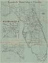
Goodrich Road Map of Florida.
Rare road map of Florida.
Choose a Collection:
- Digital Map Information
- Suitable for large format printing
- Full resolution TIFF file
- ICC color profile embedded
- Delivered instantly via download link
This Item
Enquire
Rare road map of Florida.
This is a 1920 B.F. Goodrich and Raymond Beck road map of Florida. An inset in the Gulf of Mexico details Jacksonville and a second inset illustrates the highway network in the Panhandle from Pensacola to Apalachicola. Road type and grade are defined by a representational system keyed to the legend.Publication History and Census
This map was drawn by Raymond Beck and published by B.F. Goodrich in 1920. This is the only known surviving example of the present map. A significantly different map bearing the same title that was also created by Raymond Beck and published by B.F. Goodrich appeared in 1919. We note two cataloged examples of the 1919 edition. One is part of the collection of the Touchton Map Library at the Tampa Bay History Center and the other is at the University of South Florida.Condition
Average. Wear along original fold lines. Loss at most fold intersections. Some soiling. Closed margin tear professionally repaired on verso. Text on verso.