1889 Hering Map of the Greenwich Village, New York City
MinettaBrookDrainage-hering-1889$400.00

Title
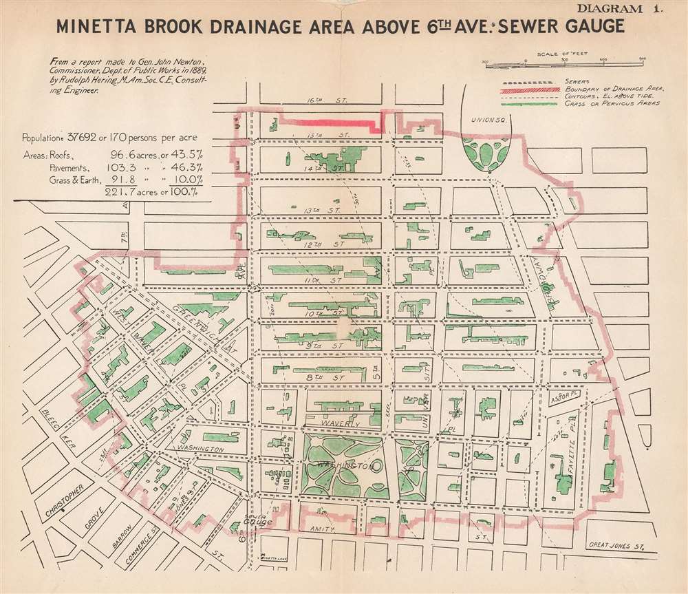
Minetta Brook Drainage Area Above 6th Ave. Sewer Gauge.
1889 (dated) 8 x 9.25 in (20.32 x 23.495 cm) 1 : 7200
1889 (dated) 8 x 9.25 in (20.32 x 23.495 cm) 1 : 7200
Description
This is an 1889 Rudolph Hering map of Greenwich Village in New York City illustrating the drainage area of Minetta Brook or Creek. Depicting from 16th Street south to Great Jones Street and from Bleecker Street east to Fourth Avenue, a solid red line delineates the drainage area. Green areas are grass or other pervious surfaces, and sewers are illustrated by parallel dashed lines. Single dashed lines mark the neighborhood's elevation above tide, which is between twenty feet and thirty-five feet. The map also provides information concerning the neighborhood's population and the area of roofs, pavements, and grass within its 221.7 acres.
Minetta Brook
Minetta Brook, also known as Minetta Creek along with a few other names, was one of Manhattan's largest natural waterways. Its course stretched nearly two miles and was fed by two tributaries. These originated at Fifth Avenue and 21st Street and Sixth Avenue and 16th Street, respectively. The brook was famous for its abundance of trout during the early colonial period and was a favorite fishing location of Native Americans before the arrival of Europeans. The city moved the stream underground in the 1820s by leveling the hills to the east of the brook and then filling it in. Today, Minetta Brook is a source of some controversy, as there are people that believe the brook is still running beneath Manhattan's streets, while others state that the water, while still around, has been diverted into storm drains and other sewers.Publication History and Census
This map was created by Rudolph Hering for a report to General John Newton in 1889. This is the only known cataloged example.Cartographer
Rudolph Hering (February 26, 1847 - May 30, 1923) was an American civil engineer, sanitary engineer, and the 'Dean of Sanitary Engineering' in the United States. Born in Philadelphia, Pennsylvania, Hering was sent to Dresden, Germany, in 1860, where he attended a public high school and then the Royal Saxon Polytechnic Institute. He graduated from the Polytechnic Institute in 1867 as a civil engineer. He returned to the United States and found work as an engineer at Prospect Park, Brooklyn and then assisted in laying out Fairmont Park in Philadelphia. After several severe yellow fever epidemics in major cities across the United States, the National Board of Health commissioned Hering to study sewerage practice in major European cities. After returning from Europe, Hering penned what was considered at the time one of the most important reports published in the United States concerning the 'fundamental principles and arrangements of structures for satisfactory removal of household wastes by water carriage'. Between 1882 and 1888 Hering worked on major projects in Philadelphia, Chicago, and New York City. Over the course of his career, he worked on water supply investigations in New York, Philadelphia, Washington, New Orleans, Minneapolis, Columbus, Montreal, and numerous other cities. In 1889 President Harrison appointed him as Chairman of a Commission to develop a program of sewerage improvement for Washington, D.C. He was married twice. His first wife was Fanny Field Gregory, with whom he had two children. Hermine Buchheim was his second wife and they had three children. More by this mapmaker...
Condition
Good. Area of infill near center along 10th Street between 6th Avenue and 5th Avenue. Another area of infill along top margin. Closed margin tears professionally repaired on verso.