1940 Jolly Lindgren Humerous Pictorial Map of Grand Canyon National Park
GrandCanyon-lindgren-1940-2$650.00

Title
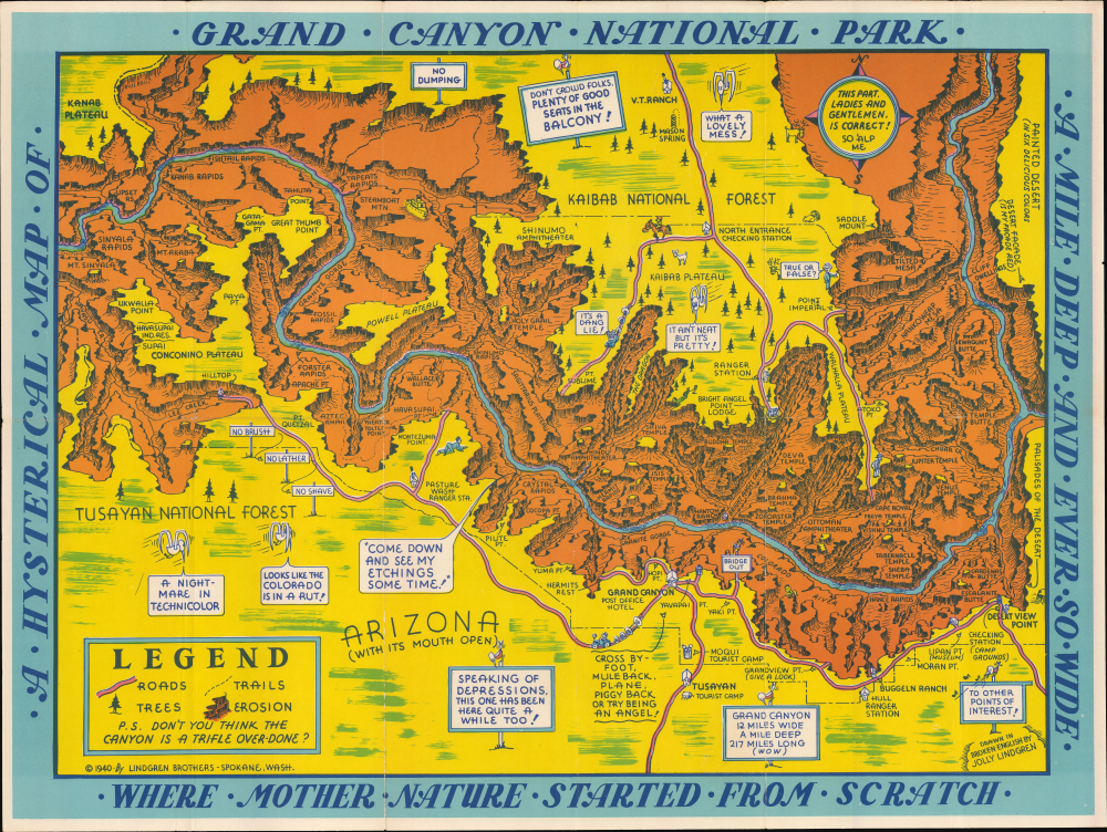
A Hysterical Map of Grand Canyon National Park. A Mile Deep and Ever So Wide. Where Mother Nature Started from Scratch.
1940 (dated) 16 x 21.5 in (40.64 x 54.61 cm) 1 : 170650
1940 (dated) 16 x 21.5 in (40.64 x 54.61 cm) 1 : 170650
Description
This is a humorous 1940 Jolly Lindgren pictorial map of Grand Canyon National Park, one of the less common works from the Hysterical Map series.
They emerged in the Interwar Period (1918 - 1939), an era defined by the breakdown of social structure, widespread disillusionment, the Great Depression, industrialization, and breakneck technological advances. In the United States, spurred by the ease of movement brought about by the automobile, infrastructure investment by New Deal programs, escapism into nature, and affordability, a nationwide love affair with our National Parks emerged - and remains.
The Lindgrens capitalized on this unique situation to introduce an affordable, mailable souvenir - the Hysterical Map. Both visually striking and funny, the Hysterical Map could be framed and displayed as a happy memento or folded and mailed to friends and family. The Lindgrens made maps of most of the Great National Parks, as well as other points of interest, though they kept a broad focus on the Western United States. Hysterical Maps remained in production until about 1954.
We invite readers to read our evolving cartobibliography of Lindgren Brothers maps here: Hysterical Maps of the Lindgren Brothers: A Cartobibliography
A Closer Look
The map depicts the Grand Canyon National Park from the Kanab Plateau and Mount Sinyala to the Painted Desert and from the Kaibab National Forest to the Tusayan National Forest. Comments and asides in Lindgren's inimitable style are scattered throughout. Lindgren's signature birds soar over the canyon, deriding his work ('A nightmare in Technicolor! and 'It ain't neat but it's pretty!') and commenting on the canyon ('Looks like the Colorado is in a rut!'). A 'No Dumping' sign is prominently displayed along the North Rim, hinting at humanity's unfortunate inclination to fill creek beds, ditches, etc., with garbage. Numerous locations throughout the canyon are labeled, including several temples (such as Isis Temple), points, gorges, buttes, and rapids along the Colorado River. Steamboat Mountain, one of the more recognizable locations within the Grand Canyon, is illustrated here as an actual steamboat. A legend in the bottom left corner explains the notations used, and asks the question, 'Don't you think the canyon is a trifle over-done?'Grand Canyon
Carved by the Colorado River over the course of millions of years, the Grand Canyon has fascinated visitors for centuries and is considered to be a holy site by the Pueblo people. Originally established as a game preserve by President Theodore Roosevelt, T.R. changed its status to a U.S. National Monument in 1908, following passage of the Antiquities Act in 1906. It would take another 11 years before Grand Canyon National Park would be established in 1919 during the presidency of Woodrow Wilson.Lindgren Brothers Hysterical Maps
Starting in 1932, the Lindgren Brothers of Spokane, Washington, began issuing medium-format pictorial maps, mostly of national parks, which they dubbed 'Hysterical.' The maps were doubtless influenced by the comparable work of American mapmakers Jo Mora and Harrison Godwin, as well as international figures like MacDonald Gill. Lindgren maps were simply illustrated with primary colors and lighthearted content, meant to get a laugh or at least a raised eyebrow.They emerged in the Interwar Period (1918 - 1939), an era defined by the breakdown of social structure, widespread disillusionment, the Great Depression, industrialization, and breakneck technological advances. In the United States, spurred by the ease of movement brought about by the automobile, infrastructure investment by New Deal programs, escapism into nature, and affordability, a nationwide love affair with our National Parks emerged - and remains.
The Lindgrens capitalized on this unique situation to introduce an affordable, mailable souvenir - the Hysterical Map. Both visually striking and funny, the Hysterical Map could be framed and displayed as a happy memento or folded and mailed to friends and family. The Lindgrens made maps of most of the Great National Parks, as well as other points of interest, though they kept a broad focus on the Western United States. Hysterical Maps remained in production until about 1954.
Publication History and Census
This map was created and published by Jolly Lindgren and published by Lindgren Brothers in 1940. There are only a handful of examples of this map in institutional collections.We invite readers to read our evolving cartobibliography of Lindgren Brothers maps here: Hysterical Maps of the Lindgren Brothers: A Cartobibliography
Cartographer
Lindgren Brothers (1928 – 1971) was a Spokane, Washington, based printer known for issuing humorous souvenir auto decals, maps, and posters. The firm was founded as a sign-painting company by Hjalmer 'Jolly' Lindgren (1895 - September 1952) and his brother Oscar 'Ott' Lindgren (1893 - 1967), born in Wisconsin to Swedish immigrants. Neither brother had middle names when they went off to fight in World War I (1914 - 1818), but as the government required it, they adopted Jolly and Ott, which stuck with them for life. Jolly was in charge of the art department and Ott was in charge of the business aspects of the firm. The company began as printers and sign makers, and also became innovators in silkscreen printing, and as the Great Depression deepened, Jolly began producing 'hysterical maps'. He declared at the time, ‘What this country needs now is something to put a smile on people's faces.' The maps are graphically interesting and intended, as the titles suggest, to amuse. The brothers focused on producing maps of popular tourist attractions, and the great national parks of the West were an obvious choice. They produced maps of Yellowstone, the Grand Canyon, Glacier, Zion, Bryce Canyon and others through the early 1940s. Following a hiatus during World War II (1939 - 1945), the company began producing car decals, some of which were simplified versions of the ‘hysterical maps'. The company sold more than ten million decals in a good year. In 1949, the company was renamed the Lindgren-Turner Company when their traveling salesman, Theodore 'Ted' Turner, Jr. (1902 - 1989), who had been with the firm since 1930, became a partner. Jolly died unexpectedly at 57 while visiting his daughter in Boise, Idaho. The firm continued under his brother, Oscar. William Shigeo Terao (1915 - 1990), who was hired after World War II by the Lindgrens and eventually became the firm's art director, created two more hysterical maps following Jolly's death. The company's last great success, after the decal market had become too competitive, was a sign that read 'No Trespassing, Survivors will be Prosecuted'. The signs became a massive success, eventually being sold in every Woolworth's department store nationwide - all 2,228 locations. Ott died in 1967 at the age of 74, leaving Turner as the last member of the original team. He, in turn, sold the firm to the Emblem Manufacturing Company based in Los Angeles, in February 1971 and he and his wife moved to New Mexico three years later to be closer to their daughter. Turner wrote a history of the Lindgren-Turner Company during his retirement and died at the age of 87 in 1989. More by this mapmaker...
Condition
Very good. Wear along original fold lines. Blank on verso.
References
Rumsey 11092.002. OCLC 456453641. Geographicus #23_1940.