This item has been sold, but you can get on the Waitlist to be notified if another example becomes available, or purchase a digital scan.
1755 Homann Heirs and Bellin Map of the Great Lakes
GreatLakes-bellinhomann-1755-2$1,250.00

Title
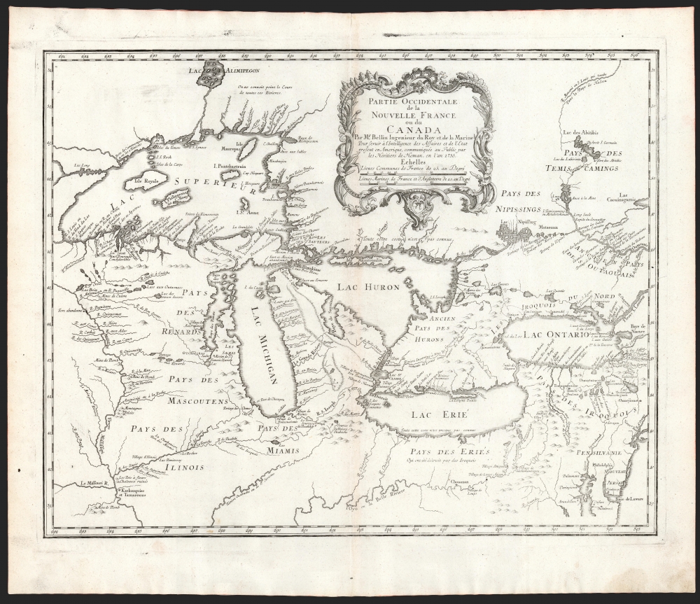
Partie Occidentale de la Nouvelle France ou du Canada.
1755 (dated) 16.5 x 21 in (41.91 x 53.34 cm) 1 : 3500000
1755 (dated) 16.5 x 21 in (41.91 x 53.34 cm) 1 : 3500000
Description
An influential map of the Great Lakes, drawn in 1755 by Jacques Nicholas Bellin, and reengraved by Homann Heirs for inclusion in their 1755 Atlas Homannianus Mathematic-Historice Delineatus. It depicts all five of the Great Lakes as well as the adjacent Indian lands and the English colonies of Pennsylvania, New Jersey, and New York.
The Source
Bellin's map is largely derived from the one he prepared for inclusion in Pierre Francois Xavier de Charlevoix's 1744 Histoire et description generale de la Nouvelle France, which in turn was based upon manuscripts compiled by Gaspard-Joseph Chaussegros de Lery (1721 - 1797), a French Canadian military engineer active around Great Lakes region in the early 18th century. Bellin engraved an expanded, second map in 1745, revising it again in 1755. It is this second state upon which Homann Heirs based this map.The Isles of Lake Superior
Despite Lake Superior having been avoided entirely in Charlevoix's visit to North America, the omission did not prevent the Jesuit from inventing the four spurious islands shown for the first time on this map, here noted as Philippeaux, Pontchartrain, Maurepas, and St. Anne. The islands were intended to honor Charlevoix' s personal patron, the Count of Maurepas, Jean-Frederic Phelypeaux (1701 - 1781). The largest of the four islands, Philippeaux, is named directly after the count. The second largest island, Pontchartrain, refers to Phelypeaux's family estate. The third island, which may in fact be a mismapping of the factual State Islands, is named after the count's seat, Maurepas. The fourth and smallest of the islands, St. Anne, references the count's patron saint. Charlevoix described the islands as being rich in minerals, leading numerous explorers to search for them in vain. Bellin dutifully introduced the four islands to his map, offered here, and such was his influence that they were subsequently copied by most subsequent cartographers, including John Mitchell in his seminal 1755 wall map of North America. (Resulting, ultimately, in the 1783 use of the imaginary Philippeaux as a landmark along the new United States - British America border.The Homann Edition
The plate was engraved by Homann Heirs shop in 1755, in response to European interest in the French and Indian War - the American theatre of the Seven Years' War. The map's details include the names and locations of the region's indigenous nations, their alliances, and their status - for example, the nation south of Lake Erie is described in French as 'The Country of the Erie, which was destroyed by the Iroquois.' The vast lands of the Miami, the Iroquois, the Erie, the Huron, the Renard, the Mascouten, and the Illinois overwhelm tiny bastions of French power in the form of various forts and missions. Among these are Fort Frontenac, Fort Niagara, Mission Francois Xavier, and the fledgling 'R. et Port de Checagou,' the future site of Chicago. The French, without the vast colonial resources of the English and Spanish, relied heavily on their alliances with indigenous populations.Political Distortion
In the lower right-hand quadrants of this map, the English colonial holdings in Pennsylvania, New Jersey, Virginia and New York are shown disproportionately small in comparison with the territory on which the map is focused. While including English colonies at all may have been an effort simply to contextualize the relevant French holdings, it would not be the first time on a map that the French had visually minimized the extent of their rival's territory.Publication History and Census
This map, based on Bellin's now rare 1755 map printed in Paris, was entirely engraved in Nuremberg for inclusion in Homann's Heirs' 1755 Atlas Homannianus Mathematic-Historice Delineatus; it would continue in print without change in their 1759 Atlas Geographicus Major. It is well represented in institutional collections.CartographerS
Jacques-Nicolas Bellin (1703 - March 21, 1772) was one of the most important cartographers of the 18th century. With a career spanning some 50 years, Bellin is best understood as geographe de cabinet and transitional mapmaker spanning the gap between 18th and early-19th century cartographic styles. His long career as Hydrographer and Ingénieur Hydrographe at the French Dépôt des cartes et plans de la Marine resulted in hundreds of high quality nautical charts of practically everywhere in the world. A true child of the Enlightenment Era, Bellin's work focuses on function and accuracy tending in the process to be less decorative than the earlier 17th and 18th century cartographic work. Unlike many of his contemporaries, Bellin was always careful to cite his references and his scholarly corpus consists of over 1400 articles on geography prepared for Diderot's Encyclopedie. Bellin, despite his extraordinary success, may not have enjoyed his work, which is described as "long, unpleasant, and hard." In addition to numerous maps and charts published during his lifetime, many of Bellin's maps were updated (or not) and published posthumously. He was succeeded as Ingénieur Hydrographe by his student, also a prolific and influential cartographer, Rigobert Bonne. More by this mapmaker...
Homann Heirs (1730 - 1848) were a map publishing house based in Nuremberg, Germany, in the middle to late 18th century. After the great mapmaker Johann Baptist Homann's (1664 - 1724) death, management of the firm passed to his son Johann Christoph Homann (1703 - 1730). J. C. Homann, perhaps realizing that he would not long survive his father, stipulated in his will that the company would be inherited by his two head managers, Johann Georg Ebersberger (1695 - 1760) and Johann Michael Franz (1700 - 1761), and that it would publish only under the name 'Homann Heirs'. This designation, in various forms (Homannsche Heirs, Heritiers de Homann, Lat Homannianos Herod, Homannschen Erben, etc..) appears on maps from about 1731 onwards. The firm continued to publish maps in ever diminishing quantities until the death of its last owner, Christoph Franz Fembo (1781 - 1848). Learn More...
Source
Atlas Homannianus Mathematic-Historice Delineatus, (Homann Heirs: Nuremburg) 1755.
Condition
Very good. Mend to top centerfold not impacting printed image.
References
OCLC 5410677. Karpinsky, L., Bibliography of the Early Printed Maps of Michigan, p.50. Kershaw, Early Printed Maps of Canada III, 950, plate 715. Phillips, A List of Maps of America, p.191. Sellers and Van Ee, Maps and Charts of North America and West Indies, 19. Heidenreich and Dahl, 'The French Mapping of North America', The Map Collector, issue 19 (June, 1982). Schwartz and Ehrenberg, The Mapping of America, p.165, pl.97.