This item has been sold, but you can get on the Waitlist to be notified if another example becomes available.
1970 Soviet Ministry of Defense Map of Soviet Engagements During World War II
GreatPatrioticWar-redbanner-1970$375.00

Title
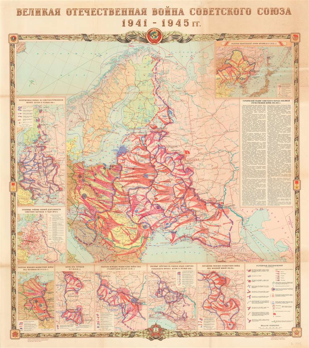
ВЕЛИКАЯ ОТЕЧЕСТВЕННАЯ ВОЙНА СОВЕТСКОГО СОЮЗА 1941 1945 rr. / Great Patriotic War of the Soviet Union 1941 - 1945.
1970 (dated) 41.5 x 36.75 in (105.41 x 93.345 cm) 1 : 5000000
1970 (dated) 41.5 x 36.75 in (105.41 x 93.345 cm) 1 : 5000000
Description
This is a 1970 Soviet Ministry of Defense wall map of Russian and Eastern Europe illustrating Soviet engagements during World War II, known in the Soviet Union as the Great Patriotic War. This beautifully produced map was probably intended for educational purposes and, with its dramatic coloring and golden border, doubtless a propagandish glorification of Soviet military prowess.
Investigating the Central Map
The central map, depicting the entirety of the Eastern Front from Berlin to the Caspian Sea and from the Arctic Ocean to the Balkans and the Black Sea, illustrates the series of Soviet counterattacks following the defense of Moscow to the capture of Berlin and meeting the American and British armies in central Europe. Solid blue and red lines mark German and Soviet front lines, respectively, and the Soviet line continues to push the German lines west back across Russia. Fronts are labeled and offensives are dated. The blue pockets marked with red 'X's indicate pockets of Nazi soldiers that were surrounded and then captured by the Red Army. The blue and red theme continues into the oceans, where icons marking surface ships, airplanes, and submarines mark both German and Soviet actions. Finally, green arrows and a green line appears in central Europe, marking the meeting of the Western Allied armies and the Red Army at the end of the war. Astute observers will also note a lone green line in the Norwegian Sea and the Barents Sea, which refers to Allied convoys of war supplies from the United States and Britain to Archangel, in northern Russia, that were meant to help the Soviets fight the Germans. Almost all of these notations are explained in a key situated in the lower right corner.The Insets
Eight inset maps partially encircle the large central map. Proceeding counterclockwise these depict: the German offensives of 1941 from just after the opening of Operation Barbarossa until they were stopped just outside Moscow; enclaves of partisan fighting behind the German lines; the capture of Berlin in April and May 1945; the Battle of Kursk in 1943; the siege and subsequent victory at Stalingrad in 1942 – 1943; actions on the Southern Front in summer and fall 1942; the counterattacks around Moscow in 1941 – 1942; and, in the upper right corner, the Soviet invasion of Manchuria in August and September 1945. Each inset has its own key explaining the various notations used. The scope of the insets varies dramatically. The map of the beginning of Operations Barbarossa, for instance, illustrates the entirety of the Eastern Front during the second half of 1941 and the map highlighting partisan attacks behind the German lines covers the same territory but depicts actions that took place over a series of years. Others, such as the maps that focus on the Battle of Kursk or Stalingrad focus on a relatively small geographic area when compared to the other maps but detail two incredibly pivotal moments in the war.Publication History
This map was created and published by the Order of the Red Banner of Labor Military Publishing House of the USSR Ministry of Defense in Moscow in 1970.Condition
Good. Exhibits wear and toning along original fold lines. Exhibits some soiling. Blank on verso.