This item has been sold, but you can get on the Waitlist to be notified if another example becomes available, or purchase a digital scan.
1852 Stansbury Map of Utah and the Great Salt Lake
GreatSaltLake2-stansbury-1852$500.00

Title
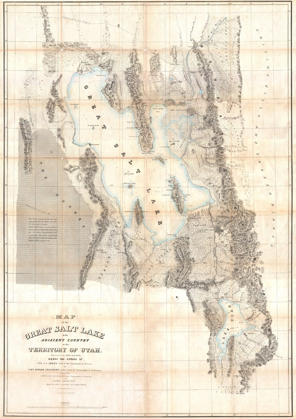
Map of the Great Salt Lake and Adjacent Country in the Territory of Utah.
1852 (undated) 44 x 31 in (111.76 x 78.74 cm)
1852 (undated) 44 x 31 in (111.76 x 78.74 cm)
Description
It had been a daring feat of exploration, succeeding where the mountain men had all failed, and by means of his map of the western portion of the lake, Stansbury had painted at least one more bold stroke into the unfinished portrait of the national landscape. - William GoetzmannThis is Stansbury's seminal 1852 map of the Great Salt Lake region in Utah. It is considered to be the first accurate survey of the Great Basin as well as a cornerstone achievement in the mapping of the American West. The first westerner to visit the Great Basin was most likely Silvestre Vélez de Escalante in the 1776, however, Escalante, who visited Utah Lake to the south, never truly laid eyes on Great Salt Lake. That honor would fall to unnamed trappers and mountain men traveling the region in search of furs and other tradable commodities. Unfortunately, few of these men were literate and did not record their discoveries. The first scientific expedition to this area was headed up by Fremont in 1843. Daunted by the season and climate, Fremont never circumnavigated the lake. That task fell to Howard Stansbury who, in 1849, was assigned by Congress to survey the Great Salt Lake, the Utah Valley, and the emigrant roads passing through the region. Stansbury, working with Gunnison, Carrington, and others, took about two years to complete his survey before presenting it to Congress in 1852. This map was part of that presentation.
Covering the region of the Great Basin from the Bear River in the north to Mount Nebo in the south, and from the Rocky Mountains in the west to the Great Plains in the east, Sansbury's map is the result of a monumental feat of exploration and scientific tenacity. The detail throughout is extraordinary, identifying springs, rivers, passes, important buildings, American Indian settlements, canals, etc. Stansbury's work and this map are responsible for creating much of the region's nomenclature, but where it is not, both Mormon and American Indian names are provided. This is also one of the earliest maps to delineate the street plan of Salt Lake City.
Stansbury attempts to provide useful information for the traveler. Both the Emigrant Road from California (passing north of the lake) and the Road From California (Passing South of the Lake) are shown. He also provides useful notations for the traveler, such as this one in the lower left quadrant
This desert consists of clay and sand impregnated with salt. When wet, it has the consistency of mortar. Lightly loaded wagons can pass between Spring Valley and Pilot Peak in the driest part of the season. Forage and water must be carried for cattle, and the journey begun in the P. M. and continued through the night. Distance between springs 70 ms.. As much as possible, Stansbury includes nautical details and depth sounding for both Great Salt Lake and Utah Lake. In the process of creating a marine survey of the Lake, the Stansbury team was also the first to identify and chart many of Great Salt Lake's Islands ,as might be deduced form their names: Stansbury Island, Carrington Island, Gunnison Island, and Fremont Island.
Wheat, in his classic study of American exploration, Mapping the Transmississippi West, devotes considerable attention to this important map,
Obviously a major production...an illuminating map of Great Salt Lake, Utah Lake, their respective valleys, and a portion of ‘Youab' (Juab) Valley to the south.... This map permanently established the cartography and many place names of northwestern Utah.... One of its most attractive features is that it gives the Indian as well as the Mormon names of the various creeks draining from the mountains. For Great Salt Lake itself the map was definitive, of course, permanent names being given to all the islands and shoreline features.... Scientific cartography for the Territory of Utah may be said to date from the appearance of this map.Following the completion of this map, Stansbury and his team returned east, in the process surveying part of the route and creating another important map of the area. A year after this map was presented in Washington, Gunnison was commissioned to return to the region in order to survey a viable route for the Pacific Railroad. In the process of completing this project, Gunnison fell afoul of the local Ute (Utah) Indians, who killed him and several other members of his party in an ambush, delaying the survey and the development of the Pacific Railroad for a number of years.
Drawn by H. Gunnison and C. Pruss. Published in 1852 as part of the Stansbury Report, which was presented to congress in that same year. The cartography of Utah and the Great Basin truly begins with this map. A seminal production and a must for any serious cartographic collection focusing on the Great Salt Lake or the American West.
CartographerS
Howard Stansbury (February 8, 1806 - April 13, 1863) was an important surveyor, cartographer, and explorer who did his most important work in Utah during the middle part of the 19th century. Born in New York City, Stansbury trained to be a Civil Engineer. Shorty after getting married to Helen Moody of Detroit in 1827, Stansbury took a position with the United States Topographical Bureau. Under that organization he surveyed the James River in 1836, and the Illinois and Kaskaskia Rivers in 1837. In 1838, he oversaw the construction of a road from Milwaukee to the Mississippi River. Later in 1838, when the U.S Corps of Topographical Engineers was created, he joined as a first Lieutenant. With the Topographical Engineers he surveyed the Great Lakes, the harbor of Portsmouth, New Hampshire, and constructed Florida's Carysfort Reef Lighthouse. During the Mexican-American War he constructed fortification in the Dry Tortugas at the westernmost point on the Florida Keys. Upon achieving the rank of Captain, Stansbury received a commissioned to head a survey of the Great Basin that would ultimately become the crowning achievement of his career. His assignment was to survey the emigrant trails to California, including the Oregon Trail, as well as the Great Salt Lake, and report on the status of the growing Mormon Community in Salt Lake City. Working with J. W. Gunnison and Alfred Carrington, a Mormon scout, Stansbury produced a masterful survey of the region that had a lasting effect not only on the development of the Great Basin, but on the development of the west in general. Upon completion of his survey, Stansbury set out on the road to Washington, completing another important survey in the process. On the way, he fell off his horse, taking an injury from which he never fully recovered. Following the presentation of his report to Congress, Stansbury was charged with additional survey work around the Great Lakes. Upon the outbreak of the American Civil War, he was assigned to recruitment duties in Ohio and later Wisconsin. Shortly after starting work at this post he suffered an abrupt heart attack and passed away. He is buried in St. Paul, Minnesota. More by this mapmaker...
John Williams Gunnison (November 11, 1812 - October 26, 1853) was a surveyor and officer in the U.S. Army. Born in New Hampshire, he attended West Point starting in 1837 and graduated second in his class. After serving as an artillery officer in fighting against the Seminoles in Florida, he was reassigned due to health reasons and joined the Army's Corps of Topographical Engineers. He spent most of the 1840s surveying lands around the Great Lakes, and in 1849 served as second-in-command to Howard Stansbury's expedition to map the Great Salt Lake. In addition to his cartographic work, Gunnison spent considerable time interacting with Mormons and wrote a book about the people and their religion on returning to Washington D.C. After additional surveying work around the Great Lakes in present-day Wisconsin, in 1853 Gunnison was assigned to lead an expedition to survey a railroad route through Utah (the Gunnison–Beckwith Expedition). While doing so, he was killed in a massacre committed by Pahvant Ute Indians, who had likely mistaken his surveying team for a group of Mormons, with whom the Pahvant were fighting a low-level war (the Walker War). In the context of existing tensions between the U.S. Government and Mormon settlers, rumors swirled that Brigham Young had orchestrated the massacre to prevent the railroad's construction, a charge which later investigations found to be baseless, but which nevertheless was widely believed at the time. The incident was one of several that increased mistrust between Mormons and the U.S. Government in the lead up to the Utah War of 1857 - 1858. Learn More...
Charles Preuss (1803 - September 2, 1854), or as he was born George Karl Ludwig Preuss, was a German-born lithographer and cartographer who produced several important maps of the American West in the middle part of the 19th Century. Preuss was born in Hohscheid, Germany, where grew up and studied the science of Geodesy. There he also studied lithography with its inventor, Aloys Snefleder. After mastering the art, he worked under the Prussian Government as a mapmaker and surveyor. Preuss immigrated to the United States with his wife and children in 1834. In the United States, he worked at a few minor drafting positions before taking work under Ferdinand Hassler and the U.S. Coast Survey. Hassler introduced Preuss to Captain John Charles Fremont, who was then planning his landmark surveying expedition to the American West. Impressed with Preuss' work, Fremont hired him as the expedition's cartographer. Preuss seems to have been singularly unimpressed with Fremont and the American West, complaining bitterly in his journals about both. He considered Fremont "childish" and the scenery "dull" and "lackluster." Nonetheless, he was convinced to participate in one expedition after another, and the maps he produced, both under Fremont and under Stansbury, were among the most important maps of the region ever drafted. These include, among many others, the first map of the Oregon Trail, the first accurate mapping of the Great Salt Lake, the naming of the Golden Gate, and the first identification of the California Gold region. Preuss's maps influenced North American cartography for the next two decades. Kemble Warren, who assembled Preuss' maps as well as the work of many others into his "General Map" of the American West, said of Preuss, "his skill in sketching topography in the field and in representing it on the map has never been surpassed in this country." Ultimately, despite his many successes, the admiration of his peers, and a life of adventure, Preuss seems to have suffered from chronic depression, apparently the result of sunstroke in California. In September of 1854, he hung himself from a tree limb in Washington, D.C. Learn More...
Source
Stansbury, H. J., An Expedition to the Valley of the Great Salt Lake of Utah…, 1852.
Condition
Very good conditon. Minor toning to lower left quadrant where originally attached to binder. Minor toning and wear along original fold lines. Else very clean. Professionally flattened and backed with Japanese paper.
References
Francaviglia, Richard V., Mapping and Imagination in the Great Basin: A Cartographic History, page 103-4. Wheat, Carl Irving, Mapping the Transmississippi West, 1540-1861 (5 vols), 765. Cohen, P. E., Mapping the West, page 164 - 166. Goetzmann, W. H., Army Exploration in the American West: 1803-1863, page 222. Rumsey, 0950.001. Wagner, H.R. and Camp, C. L., The Plains and teh Rockies: A Critical Bibliography of Exploration, Adventure, and Travel in the American West, 1800 - 1865, 219:2. Moffat, R. M., Printed Maps of Utah to 1900: An Annotated Cartobibliography, 26.