1895 U.S. Government Map of Russia and Trans-Siberian Railway Construction
GreatSiberianRailway-usgovt-1895$450.00

Title
Map of the Russian Empire Showing the Great Siberian Railway.
1895 (undated) 12.25 x 20 in (31.115 x 50.8 cm) 1 : 16500000
1895 (undated) 12.25 x 20 in (31.115 x 50.8 cm) 1 : 16500000
Description
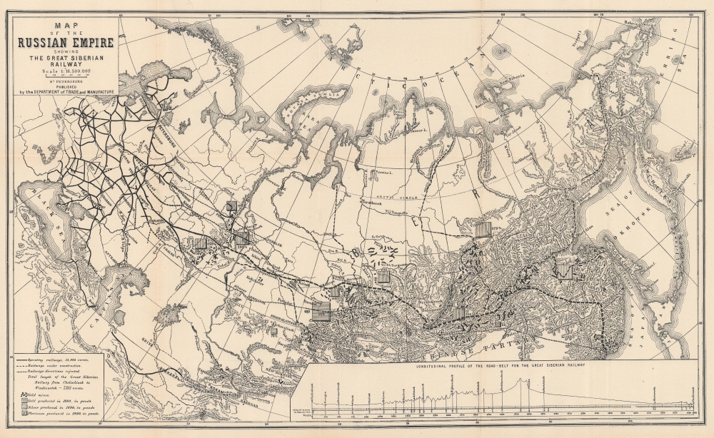
This is a c. 1895 U.S. government map of Russia illustrating the construction of the Trans-Siberian Railroad. It highlights the progress and development of the continent-spanning railroad as well as Russia's rich natural resources - which the railroad would make accessible.
Boxes throughout Russia highlight deposits of gold, silver, and platinum currently exploited by the Russian government. The production of each deposit is noted. A profile of the Trans-Siberian Railroad route from Chelyabinsk (Cheliabinsk here) to Vladivostok appears in the lower right quadrant and provides the viewer with a different perspective concerning the difficulty of building the railroad.
A Closer Look
The map embraces from eastern Europe to the Pacific Ocean and from the Arctic Ocean to northern Afghanistan. Black lines highlight existing railway lines in eastern Europe and western Russia, as well as in the Caucasus and in central Asia between the Caspian Sea and Samarkand. The Trans-Siberian Railway extends east to Miass (per the map) with a dashed line illustrating the projected route to Vladivostok. Several 'rejected lines' appear in western Russia, probably marking proposed routes for the Trans-Siberian Railway. Another 'rejected line' connects Irkutsk with Vladivostok, which is very similar to the China Eastern Railway that Tsarist Russia began constructing after an 1896 concession from Qing China.Boxes throughout Russia highlight deposits of gold, silver, and platinum currently exploited by the Russian government. The production of each deposit is noted. A profile of the Trans-Siberian Railroad route from Chelyabinsk (Cheliabinsk here) to Vladivostok appears in the lower right quadrant and provides the viewer with a different perspective concerning the difficulty of building the railroad.
Trans-Siberian Railway
Russian ambitions to connect Moscow with Vladivostok on the Sea of Japan/Korea began as early as the 1850s. As Russia expanded eastward territorially, its surging population did not follow, leaving vast swaths of fertile land largely empty of major settlement. Riverways and poorly maintained roads unsuitable for wheeled transport provided the only direct connection between Moscow and the frontiers of the empire. The need for a railroad became ever more pressing. Despite decades of rejected plans failed starts, Trans-Siberian Railroad Committee, personally headed by Tsar Nicholas II, saw construction on the Trans-Siberian Railway began in March 1891. Trains began running in 1904, but construction was not finalized until 1916.Publication History and Census
This map was likely published c. 1895 by the U.S. government in one of its many publications from a map originally published by the Russian Department of Trade and Manufacture. We have located a reduced version of the present map published in Volume XII of the Special Consular Reports Highways of Commerce. The Ocean Lines, Railways, Canals, and other Trade Routes of Foreign Countries, but we have been unable to locate the source for the present folding edition. We know of only one other cataloged example, and it is in private hands.Condition
Very good. Light wear along original fold lines.