This item has been sold, but you can get on the Waitlist to be notified if another example becomes available, or purchase a digital scan.
1694 Antonio Pacifico Venetian Map of Greece and Balkans - Great Turkish War
GreciaArcipelago-pacifico-1694$2,750.00

Title
Grecia, et Arcipelago Descrizzione Topografica di P.Pier Anto. Pacifico di S. Toma Consecrata All'Altezze Serenissime de Carlo Filippi, e Christiano Lodovio Marchesi di Brandemburg, e c.
1694 (undated) 23.5 x 29.75 in (59.69 x 75.565 cm) 1 : 1220
1694 (undated) 23.5 x 29.75 in (59.69 x 75.565 cm) 1 : 1220
Description
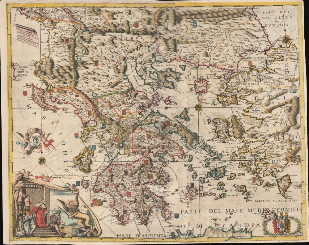
A spectacular map c. 1694 Pietro Antonio Pacifico map of Greece and the Balkans issued in Venice during the Morea War (1684 - 1699). The map is uncatalogued, this being only the 2nd known example, but exhibits the extensive Venetian contribution to the mapping of Greece in during the Second Venation Occupation of Greece, part of the larger Great Turkish War (1683 - 1699).
Stella Chrysochoou, in her paper 'Venetian Contribution to the Mapping of the Peloponnese at the End of the 17th c.,' provides the only known analysis of this map, based on images of the Sotheby's example (see below),
A Closer Look
Coverage embraces most of Greece and the Balkans, extending form the Gulf of Venice to the Black Sea and from Bulgaria and Serbia to northern Crete (Candia), thus embracing not only the sea of the Morea War, but also the greater theater of the Great Turkish War. Heraldic crests throughout indicate the claims of various players, including the Venetians, Albanians, and Ottomans. The cartography is attributed to the Venetian priest and geographer Pietro Antonio Pacifico, who was likely directly involved in the map's production.Stella Chrysochoou, in her paper 'Venetian Contribution to the Mapping of the Peloponnese at the End of the 17th c.,' provides the only known analysis of this map, based on images of the Sotheby's example (see below),
The map is unknown in the bibliography and is not contained in the Zacharakis' catalogue. In the cartouche situated in the bottom left-hand corner we see the Duke of Venice and the winged Lion, symbol of the Serenissima, brandishing his sword. In the bottom right-hand corner there is an escutcheon, obviously that of the house of Brandenburg. The outline of the map is quite different from the ones we have known till now, the widest distortions occurring in the area of the Chalkidiki. At this point, in fact, it reminds us of the maps of Vicenzo Coronelli. The island of Crete follows the advanced cartographic prototype of Francesco Basilicata, while the shape of the Peloponnese is reminiscent of the two maps examined immediately previously. The outlines of the Ionian Islands must be based on some unknown manuscript surveys. Moreover, the map is dotted with heraldic shields scattered all over the Greek territory.
Historical Context - The Morea War
The Morea War (1684 - 1699) was a conflict fought in the Peloponnese (Morea) in southern Greece, primarily between the Republic of Venice and the Ottoman Empire. It was part of the wider Great Turkish War (1683 - 1699, which involved several European powers aiming to push back against Ottoman territorial expansion in Europe. Led by the charismatic Venetian Doge, Francesco Morosini (1619 - 1694), the Venetians captured significant territories in the Morea, including the cities of Kalamata, Nafplion, and Patras, marking a high point in Venetian military achievements. The war was characterized by intense land battles and naval. The 1699 Treaty of Karlowitz eventually ended the conflict, leading to significant territorial gains for Venice in the Morea, though by 1715 most of these were lost to the Ottoman Empire in subsequent wars.Dedication
The dual dedication to Carlo Filippo and Christiano Lodovio, likely refers to Margrave Charles Philip of Brandenburg-Schwedt (1673 - 1695) and Margrave Christian Ludwig of Brandenburg-Schwedt (1677 - 1734), respectively. The margravial title was given to princes of the Prussian Royal House and did not express a territorial status, although it did come with considerable wealth and privilege. In this case, the dedication likely references their roles as Electors of the Holy Roman Empire, which was involved in the Great Turkish War actively pressuring the Ottomans from the north. (This second individual, Christian Ludwig, is best known as the recipient of Bach's Brandenburg Concertos, although, being deemed too complex, were never performed in his lifetime.)Publication History and Census
This map was compiled in Venice after (or by) Pietro Antonio Pacifico, an Venetian priest, historian, and geographer. The engraving features the monogram 'Isdo:Ros::li Scupt', which can likely be resolved to 'Isidoro Rosselli', although this is not a known engraver. The map closely resembles style, engraving, and content a map of the Morea, as well as other maps and engravings, included in Giacomo Franconio's 1689 Teatro delle piu moderne imprese de guerra fatte si nell Ungheria come nella Dalmatia Morea et altri luoghi. It is likely by the same hand. However, this map is itself not included in any known examples of that or any other work. It is uncatalogued; however, we do note an example of this map sold at Sotheby's London in 1993. No other known examples.Cartographer
Pietro Antonio Pacifico (fl. c. 1680 - 1710) was an Italian priest, historian, and geographer active in Venice in the late 17th and early 16th centuries. He was a priest of the church of San Tomà, Venice. He is best known for his Cronica Venetia and his geographical descriptions of Greece. More by this mapmaker...
Condition
Good. Expertly remargined. Light scattered foxing.
References
Stella Chrysochoou, 'Venetian Contribution to the Mapping of the Peloponnese at the End of the 17th c.' (Συμβολή των Ενετών στη χαρτογράφηση της Πελοποννήσου...), page 15-16.