This item has been sold, but you can get on the Waitlist to be notified if another example becomes available, or purchase a digital scan.
1842 Malte-Brun Map of Greece and the Archipelago
Greece-maltebrun-1842$50.00

Title
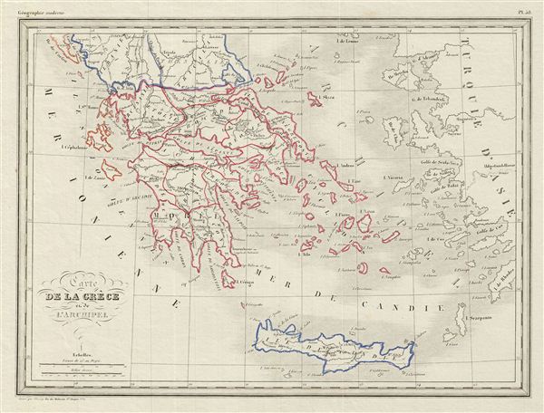
Carte de la Grece et de l'Archipeil.
1842 (undated) 9.5 x 13 in (24.13 x 33.02 cm)
1842 (undated) 9.5 x 13 in (24.13 x 33.02 cm)
Description
This is a fine example of Conrad Malte-Brun's 1842 map of Greece and the Archipelago. It covers Greece from Albania to the Island of Candia or Crete. Boundaries are outlined in color according to regions and territories. Several cities, towns, rivers, lakes, islands and various other topographical details are noted. This map was engraved by Thierry and issued as plate no. 38.
Cartographer
Conrad Malte-Brun (August 12, 1755 - December 14, 1826) was an important late 18th and early 19th century Danish / French cartographer and revolutionary. Conrad was born in Thisted, Denmark. His parents encouraged him to a career in the Church, but he instead enrolled in the University of Copenhagen. In the liberal hall of academia Conrad became an ardent supporter of of the French Revolution and the ideals of a free press. Despite the harsh censorship laws of crown prince Frederick VI, Malte-Brun published numerous pamphlets criticizing the Danish government. He was finally charged with defying censorship laws in 1799 and forced to flee to Sweden and ultimately France. Along with colleague Edme Mentelle, Malte-Brun published his first cartographic work, the Géographie mathématique, physique et politique de toutes les parties du monde (6 vols., published between 1803 and 1807). Conrad went on to found Les Annales des Voyages (in 1807) and Les Annales des Voyages, de la Géographie et de l'Histoire (in 1819). He also founded the Paris Société de Géographie . In time, Conrad Malte-Brun became known as one of the finest French cartographers of his time. His son Victor Adolphe Malte-Brun (1816 - July 13, 1889) followed in his footsteps, republishing many of Conrad's original 18th century maps as well as producing numerous maps of his own. The Malte-Brun firm operated well into the 1880s. More by this mapmaker...
Source
Malte-Brun, Atlas Complet du Precis de la Geographie Universelle, (Paris) 1842.
Condition
Very good. Original platemark visible. Blank on verso.