1538 Münster Map of Greece, Asia Minor and the Black Sea
Greece-munster-1538$600.00

Title
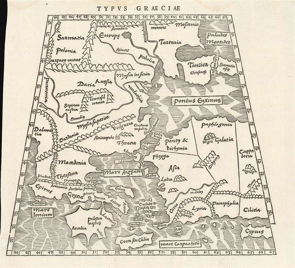
Typus Graeciae.
1538 (undated) 10.5 x 11.5 in (26.67 x 29.21 cm) 1 : 7400000
1538 (undated) 10.5 x 11.5 in (26.67 x 29.21 cm) 1 : 7400000
Description
This is a rare 1538 map of Greece and the region surrounding Constantinople, executed by Sebastian Münster for inclusion in his edition of Solinus' Polyhistor. It predates by two years the map of Greece in Münster's 1540 edition of Ptolemy'sGeographia, but it shares with other early maps of Greece the Ptolemaic conic projection. It is a sixteenth century woodcut showing third century geographical knowledge of the region - although at its northern extents, contemporary place names intrude. The map extends from Dalmatia in the west to Cappadocia, Cilicia and Cyprus in the east; it extends from Crete and Cyprus in the south to Poland, Muscovy and Sarmatia in Europe in the north. The Black Sea and the Meotian Swamp (the Sea of Azov) also appear. The map is boldly and legibly presented, with hachured oceans, and with mountains shown pictorially. The cities of Adrianopolis and Constantinople are marked pictorially as well, suggesting their greatness.
In Support of Solinus
While the physical geography of the map is basically Ptolemaic, the names of nations, and people, however, are consistent with those appearing in Solinus' text - a sensible choice, indicating that with this map Münster was applying his best available topography specifically in order to illustrate and clarify the work in which the map was to appear.Publication History and Census
This map was first issued in the 1538 edition of Solinus' Polyhistor, which was published by Petri but for which Münster also supplied the text and presumably the transcription of the 3rd century work. A 1543 edition was also printed including this map. The two editions are easily distinguished: the map title of the the 1543 second edition has a full stop not present on this first edition of 1538. About thirty examples of this edition of Polyhistor are catalogued in OCLC, with some 23 of the 1543 edition. We see examples of the separate map in only three institutional collections: The Bayerische Staatsbibliothek, Universitatsbibliothek Eichstatt, and the National Library of Australia.CartographerS
Sebastian Münster (January 20, 1488 - May 26, 1552), was a German cartographer, cosmographer, Hebrew scholar and humanist. He was born at Ingelheim near Mainz, the son of Andreas Munster. He completed his studies at the Eberhard-Karls-Universität Tübingen in 1518, after which he was appointed to the University of Basel in 1527. As Professor of Hebrew, he edited the Hebrew Bible, accompanied by a Latin translation. In 1540 he published a Latin edition of Ptolemy's Geographia, which presented the ancient cartographer's 2nd century geographical data supplemented systematically with maps of the modern world. This was followed by what can be considered his principal work, the Cosmographia. First issued in 1544, this was the earliest German description of the modern world. It would become the go-to book for any literate layperson who wished to know about anywhere that was further than a day's journey from home. In preparation for his work on Cosmographia, Münster reached out to humanists around Europe and especially within the Holy Roman Empire, enlisting colleagues to provide him with up-to-date maps and views of their countries and cities, with the result that the book contains a disproportionate number of maps providing the first modern depictions of the areas they depict. Münster, as a religious man, was not producing a travel guide. Just as his work in ancient languages was intended to provide his students with as direct a connection as possible to scriptural revelation, his object in producing Cosmographia was to provide the reader with a description of all of creation: a further means of gaining revelation. The book, unsurprisingly, proved popular and was reissued in numerous editions and languages including Latin, French, Italian, and Czech. The last German edition was published in 1628, long after Münster's death of the plague in 1552. Cosmographia was one of the most successful and popular books of the 16th century, passing through 24 editions between 1544 and 1628. This success was due in part to its fascinating woodcuts (some by Hans Holbein the Younger, Urs Graf, Hans Rudolph Manuel Deutsch, and David Kandel). Münster's work was highly influential in reviving classical geography in 16th century Europe, and providing the intellectual foundations for the production of later compilations of cartographic work, such as Ortelius' Theatrum Orbis Terrarum Münster's output includes a small format 1536 map of Europe; the 1532 Grynaeus map of the world is also attributed to him. His non-geographical output includes Dictionarium trilingue in Latin, Greek, and Hebrew, and his 1537 Hebrew Gospel of Matthew. Most of Munster's work was published by his stepson, Heinrich Petri (Henricus Petrus), and his son Sebastian Henric Petri. More by this mapmaker...
Gaius Julius Solinus (c. 290 - 350) was a Latin grammarian and compiler. His De mirabilibus mundi (The Wonders of the World) survived, recopied well into the 16th century as a valuable description of the ancient world. It touches on social, religious and natural history as understood at the time, drawing heavily from both Pliny's Natural History and Pomponius Mela's Geography. As such, rather than being a mathematical geography in the school of Ptolemy, Solinus' work concerns more the description of places than their physical location. There is considerable debate regarding exactly when Solinus was alive, with scholars putting forth dates nearly up to 100 years apart. I this we are following the scholarship of Fernàndez Nieto, who offers dates from (290 - 350). Some scholars offer a specific death date of January 2, 400, which while possible is unconfirmed. Learn More...
Heinrich Petri (1508 - 1579) and his son Sebastian Henric Petri (1545 – 1627) were printers based in Basel, Switzerland. Heinrich was the son of the printer Adam Petri and Anna Selber. After Adam died in 1527, Anna married the humanist and geographer Sebastian Münster - one of Adam's collaborators. Sebastian contracted his stepson, Henricus Petri (Petrus), to print editions of his wildly popular Cosmographia. Later Petri, brought his son, Sebastian Henric Petri, into the family business. Their firm was known as the Officina Henricpetrina. In addition to the Cosmographia, they also published a number of other seminal works including the 1566 second edition of Nicolaus Copernicus's De Revolutionibus Orbium Coelestium and Georg Joachim Rheticus's Narratio. Learn More...
Source
Solinus, Gaius Julius / Münster, Sebastian Polyhistor (Petri, H., Basel), 1538.
Condition
Very good condition. Filled marginal wormhole just touching left border.
References
OCLC 162336342. Zacharakis, Christos G., A Catalogue of Printed Maps of Greece 1477-1800, 2585.