This item has been sold, but you can get on the Waitlist to be notified if another example becomes available, or purchase a digital scan.
1878 Wyld Map of Turkey in Europe w/ Ethnological Shading
GreeceBalkansEthno-wyld-1878$950.00


Title
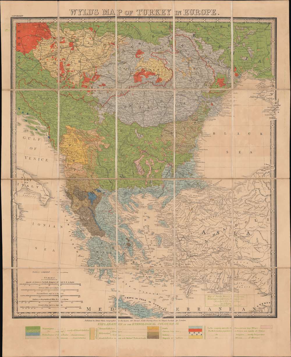
Wyld's Map of Turkey in Europe.
1878 (undated) 25.75 x 21 in (65.405 x 53.34 cm) 1 : 2816000
1878 (undated) 25.75 x 21 in (65.405 x 53.34 cm) 1 : 2816000
Description
A most intriguing c. 1878 ethnographic and infographic map of Greece and the Balkans issued by James Wyld against the backdrop of the Russo-Turkish War and systematic ethnic genocide. Coverage extends from the Gulf of Venice to the Crimea and from Vienna to Crete. Overprinting illustrates the region's complex ethnic and religious mélange. The map breaks down areas according to both ethnicity and religion, also indicating those areas where different groups live side by side, and those areas occupied by the Ottomans. The region's religious diversity, as well as ancient ethnic rivalries, has led to a long history of ethnic warfare.
Russo-Turkish War (1877 - 1878)
Although not referenced specifically, this map was published to illustrate the complex ethnic and religious terrain of the Russo-Turkish War. Fought primarily in the Balkans, the war pitted the Ottoman Empire against a Russian-led coalition of Eastern Orthodox Christian principalities composed of Bulgaria, Romania, Serbia, and Montenegro. The conflict emerged from 19th century Balkan nationalism and anti-Islam sentiment fanned by Russian ambitions to recover territory lost during the Crimean War (1853 - 1856). Over the course of the war, Romania, Serbia, and Montenegro formally proclaimed independence from the Ottoman Empire. Bulgaria emerged as an autonomous state after some 5 centuries of Ottoman rule. Independence was hard fought, the war being defined by atrocities and ethnic cleansing, with all sides committing horrifying massacres.Publication History and Census
This map was published by James Wyld in London. While undated, the British Library dates their copy to 1878, which we agree is a reasonable guesstimate. The only other known example is at the British Library.Cartographer
Wyld (1823 - 1893) was a British publishing firm active throughout the 19th century. It was operated by James Wyld I (1790 - 1836) and his son James Wyld II (November 20, 1812 - 1887) were the principles of an English mapmaking dynasty active in London during much of the 19th century. The elder Wyld was a map publisher under William Faden (1749 - 1836) and did considerable work on the Ordinance Survey. On Faden's retirement in 1823, Wyld took over Faden's workshop, acquiring many of his plates. Wyld's work can often be distinguished from his son's maps through his imprint, which he signed as 'Successor to Faden'. Following in his father's footsteps, the younger Wyld joined the Royal Geographical Society in 1830 at the tender age of 18. When his father died in 1836, James Wyld II was prepared to fully take over and expand his father's considerable cartographic enterprise. Like his father and Faden, Wyld II held the title of official Geographer to the Crown, in this case, Queen Victoria. In 1852, he moved operations from William Faden's old office at Charing Cross East (1837 - 1852) to a new, larger space at 475 Strand. Wyld II also chose to remove Faden's name from all of his updated map plates. Wyld II continued to update and republish both his father's work and the work of William Faden well into the late 1880s. One of Wyld's most eccentric and notable achievements is his 1851 construction of a globe 19 meters (60 feet) in diameter in the heart of Leicester Square, London. In the 1840s, Wyld also embarked upon a political career, being elected to parliament in 1847 and again in 1857. He died in 1887 following a prolific and distinguished career. After Wyld II's death, the family business was briefly taken over by James John Cooper Wyld (1844 - 1907), his son, who ran it from 1887 to 1893 before selling the business to Edward Stanford. All three Wylds are notable for producing, in addition to their atlas maps, short-run maps expounding upon important historical events - illustrating history as it was happening - among them are maps related to the California Gold Rush, the New South Wales Gold Rush, the Scramble for Africa, the Oregon Question, and more. More by this mapmaker...
Condition
Very good. Light even toning. Original slipcase.
References
OCLC 557759859.