This item has been sold, but you can get on the Waitlist to be notified if another example becomes available, or purchase a digital scan.
1770 Bellin Map of Greenland and Iceland
GreenlandIceland-bellin-1770$137.50

Title
Carte du Groenland.
1770 (undated) 8 x 10.5 in (20.32 x 26.67 cm) 1 : 9300000
1770 (undated) 8 x 10.5 in (20.32 x 26.67 cm) 1 : 9300000
Description
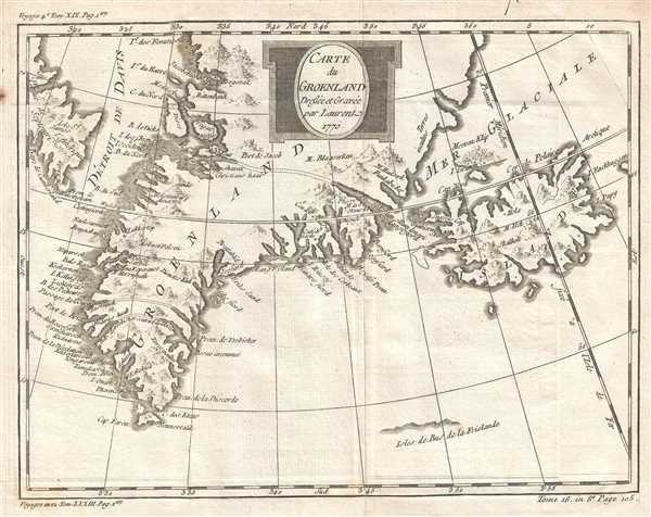
This is a curious 1770 Jacques Nicolas Bellin map of Greenland and Iceland. The map depicts the region from the coast of North America to Iceland and from northern Greenland to the North Atlantic Ocean. Originally printed in volume eighteen of Jean-François de la Harpe's masterwork Abrégé de l'Histoire Générale des Voyages (for which Bellin created all the maps), this work appears to compile several different mythical locations believed to exist in this region, including Frobisher's Strait and Frisland.
It would not be until the voyages of John Davis in 1585-87 that it would become clear that Frobisher had not been exploring between America and Asia, but between Greenland and North America. The Davis Strait (illustrated here between Greenland and Labrador) is named after him. Even with this revelation, it was believed that Frobisher had indeed discovered a strait, but that it was, in fact, located on the southern tip of Greenland. Thus, most sixteenth and seventeenth century works depicting Frobisher's Strait locate it in southern Greenland stretching from the east coast to the Davis Strait.
This map was created by Jacques Nicolas Bellin and was originally published in Jean-François de la Harpe's Abrégé de l'Histoire Générale des Voyages.
Frobisher's Strait
Frobisher's Strait began appearing on maps in southern Greenland following Sir Martin Frobisher's 1574 expedition to locate the Northwest Passage. When Frobisher returned from his voyage, he declared that he had, in fact, discovered a strait with America on one side and Asia on the other, which he of course named after himself. It quickly became evident to his contemporaries that he had been mistaken about his true location, but had, in fact, been traveling through a strait across southern Greenland. This strait, still known as Frobisher's Strait, quickly began to appear on maps of the era. Cartographers and other explorers, however, could not completely agree on the correct location for Frobisher's Strait, which is we believe to be the reason for not one, but three different straits across southern Greenland in this work by Bellin.It would not be until the voyages of John Davis in 1585-87 that it would become clear that Frobisher had not been exploring between America and Asia, but between Greenland and North America. The Davis Strait (illustrated here between Greenland and Labrador) is named after him. Even with this revelation, it was believed that Frobisher had indeed discovered a strait, but that it was, in fact, located on the southern tip of Greenland. Thus, most sixteenth and seventeenth century works depicting Frobisher's Strait locate it in southern Greenland stretching from the east coast to the Davis Strait.
Frisland
Frisland, also known as Friesland, Frischlant, Frislana, Frislandia, or Fixland, is a mythical island located to the south or Southwest of Iceland in the North Atlantic. Although its exact origin is unknown, it is believed that Frisland was originally an approximation of the location of Iceland. However, in 1558, Frisland appeared on the influential Zeno map as a separate landmass. This incorrect mapping led to Frisland inclusion on maps of the North Atlantic for the next hundred years, and only the charting and mapping of the North Atlantic by explorers, notably of English and French origin, dispensed with the myth of Frisland.This map was created by Jacques Nicolas Bellin and was originally published in Jean-François de la Harpe's Abrégé de l'Histoire Générale des Voyages.
Cartographer
Jacques-Nicolas Bellin (1703 - March 21, 1772) was one of the most important cartographers of the 18th century. With a career spanning some 50 years, Bellin is best understood as geographe de cabinet and transitional mapmaker spanning the gap between 18th and early-19th century cartographic styles. His long career as Hydrographer and Ingénieur Hydrographe at the French Dépôt des cartes et plans de la Marine resulted in hundreds of high quality nautical charts of practically everywhere in the world. A true child of the Enlightenment Era, Bellin's work focuses on function and accuracy tending in the process to be less decorative than the earlier 17th and 18th century cartographic work. Unlike many of his contemporaries, Bellin was always careful to cite his references and his scholarly corpus consists of over 1400 articles on geography prepared for Diderot's Encyclopedie. Bellin, despite his extraordinary success, may not have enjoyed his work, which is described as "long, unpleasant, and hard." In addition to numerous maps and charts published during his lifetime, many of Bellin's maps were updated (or not) and published posthumously. He was succeeded as Ingénieur Hydrographe by his student, also a prolific and influential cartographer, Rigobert Bonne. More by this mapmaker...
Source
de la Harpe, J.-F., Abrégé de l'Histoire Générale des Voyages, Tome 18 (Paris) 1770.
Condition
Very good. Even overall toning. Light wear along original fold lines. Blank on verso.
References
OCLC 163345511.