1814 Thomson / Kirkwood Map of Guadaloupe, Antigua, Marie Galante (West Indies)
Guadaloupe-thomson-1814$250.00

Title
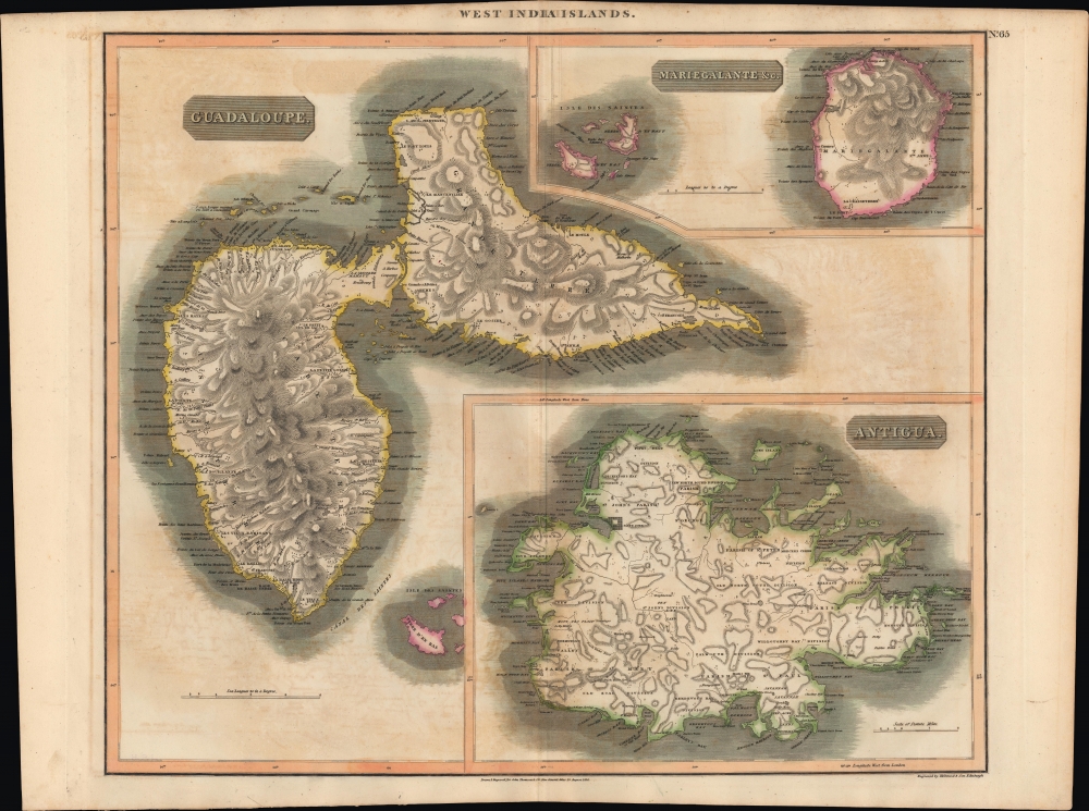
West Indies. Guadaloupe. Antigua. MarieGalante etc.
1814 (dated) 20.5 x 24 in (52.07 x 60.96 cm) 1 : 120000
1814 (dated) 20.5 x 24 in (52.07 x 60.96 cm) 1 : 120000
Description
An example of John Thomson's hand-colored 1814 map of the West India islands of Antigua, Guadeloupe, and Marie-Galante.
The modern history of these islands was defined by the slave trade and plantation economies, but the years immediately preceding this map's publication were highly tumultuous, especially for Guadeloupe, which saw foreign invasion (it changed hands between Britain, France, and, briefly, Sweden, during the French Revolutionary and Napoleonic Wars (1803 - 1815)), the abolition and reimposition of slavery, and consequent slave uprisings.
A Closer Look
The West Indian islands of Antigua, Guadeloupe, and Marie-Galante are depicted in detail with attention to rivers, topography, towns and villages, and major port cities. Even individual buildings, including churches and windmills, are illustrated. Saint John (Saint John's) on Antigua stands out for its size and geometric plan.The modern history of these islands was defined by the slave trade and plantation economies, but the years immediately preceding this map's publication were highly tumultuous, especially for Guadeloupe, which saw foreign invasion (it changed hands between Britain, France, and, briefly, Sweden, during the French Revolutionary and Napoleonic Wars (1803 - 1815)), the abolition and reimposition of slavery, and consequent slave uprisings.
Publication History and Census
This map was prepared by John Thomson and engraved by (Robert) Kirkwood and Son in Edinburgh for inclusion in Thomson's New General Atlas, which went through multiple printings in Edinburgh, London, and Dublin between 1815 and 1817. Examples of the map display different pagination (or none at all) and other minor details depending on the printing.CartographerS
John Thomson (1777 - c. 1841) was a Scottish cartographer, publisher, and bookbinder active in Edinburgh during the early part of the 19th century. Thomson apprenticed under Edinburgh bookbinder Robert Alison. After his apprenticeship, he briefly went into business with Abraham Thomson. Later, the two parted ways, John Thomson segueing into maps and Abraham Thomson taking over the bookbinding portion of the business. Thomson is generally one of the leading publishers in the Edinburgh school of cartography, which flourished from roughly 1800 to 1830. Thomson and his contemporaries (Pinkerton and Cary) redefined European cartography by abandoning typical 18th-century decorative elements such as elaborate title cartouches and fantastic beasts in favor of detail and accuracy. Thomson's principle works include Thomson's New General Atlas, published from 1814 to 1821, the New Classical and Historical Atlas of 1829, and his 1830 Atlas of Scotland. The Atlas of Scotland, a work of groundbreaking detail and dedication, would eventually bankrupt the Thomson firm in 1830, at which time their plates were sequestered by the court. The firm partially recovered in the subsequent year, allowing Thomson to reclaim his printing plates in 1831, but filed again for bankruptcy in 1835, at which time most of his printing plates were sold to A. K. Johnston and Company. There is some suggestion that he continued to work as a bookbinder until 1841. Today, Thomson maps are becoming increasingly rare as they are highly admired for their impressive size, vivid hand coloration, and superb detail. More by this mapmaker...
Robert Kirkwood (December 8, 1774 – November 14, 1818) was a Scottish engraver active in Edinburgh during the late 18th and early 19th century. He is the scion of the important Scottish Kirkwood family, who produced a number of great engravers. His father was James Kirkwood, another well-known Edinburgh engraver, and probably the man who trained him in the engraver's art. Initially he patterned with his father and they published under the imprint of 'Kirkwood and Son,' but after about 1814 to his death, he published under his own name. Around 1803 Kirkwood invented and patented a modification to the standard printing press that increased printing speeds. He died at his home, 3 Arniston Place, in Edinburgh. He was survived by his son, also Robert Kirkwood (1798 – 1843) who continued the family engraving enterprise. Learn More...
Source
Thomson, J., A New General Atlas, (Edinburgh) 1817.
Thomson's New General Atlas was first published in 1817 and continued to be published until about 1821. This is the first of Thomson's major cartographic works and the atlas for which is most celebrated. The New General Atlas follows in the Edinburgh School, which eschews excessive decoration in favor of a more minimalistic fact-based cartographic vision, as established by John Pinkerton, Laurie and Whittle, John Cary, and others in the previous decades. The maps are notable for their massive scale, heavy stock, elegant color work, and easy-to-read typefaces. Although the atlas stopped being published after 1821, Thomson continued to offer 'supplementary' maps that could be tipped into the atlas as late as 1830, when he declared bankruptcy. The maps in the Thomson Atlas were engraved by Thomas Clerk, William Dassauville, Nathaniel Rogers Hewitt, James Kirkwood, Robert Kirkwood, John Menzies, George Menzies, Edward Mitchell, John Moffatt, Samuel John Neele, Robert Scott, and James Wyld.
Condition
Good. Light offsetting. Trimmed unevenly at left edge.
References
Catalogue of maps of Hispanic America, v. 1, p. 245. Rumsey 1007.071 (alternate printing).