This item has been sold, but you can get on the Waitlist to be notified if another example becomes available, or purchase a digital scan.
1900 Chinese Map of Guangzhou (Canton), China
Guangzhou-yangcheng-1900$4,000.00

Title
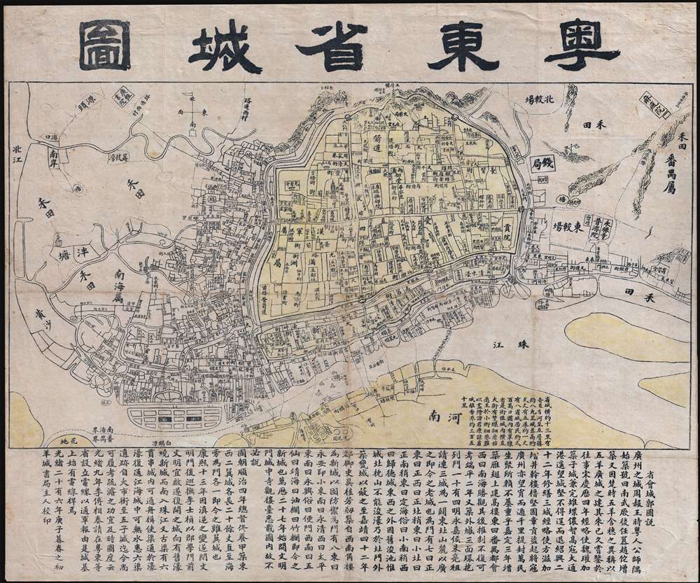
粵東省城圖 / East Guangdong Province City Map. / Yue Dong Sheng Cheng Tu.
1900 (dated) 20.25 x 24.25 in (51.435 x 61.595 cm) 1 : 10000
1900 (dated) 20.25 x 24.25 in (51.435 x 61.595 cm) 1 : 10000
Description
This is a rare Qing Dynasty era Guangxu 26 or 1900 Chinese map of Guangzhou or Canton printed in Guangzhou by the Yangcheng Bookstore (澄天阁点石 / 澄天閣點石書局). It is one of the earliest known examples of Chinese commercial cartography. The map is oriented to the north, looking at the city of Guangzhou from the south side of the Pearl River. The city walls and low mountains are apparent in the distance. Dotted lines on the Pearl Liver indicate river crossings and routes to Haudi (花地). At the base of the map, extensive textual annotation in Chinese describes the development of the city.
Content on the Map
Among the prominent locations illustrated are the Five-Storied Pagoda known today and Zhenghai Tower, the Flower Pagoda, and the Lighthouse Minaret of Huaisheng Mosque. Also noted are the Guangdong Governor's office, the 'General's Office', the Gongyuan (贡院), where civil service exams are conducted, and the original Guangya Academy (广雅书院), a precursor to the modern day Guangya High School. The Haizhu Fort, which played an important role the Opium Wars, is also present. This fort and the rock outcropping on which it rested, Haizhu Rock, were blown up in 1931 as they obstructed river navigation.Chinese Commercial Cartography
Although not the first map of Guangzhou, it is important to recognize that it was not issued by a foreign agency or by the municipal government, but by the Yangcheng Bookstore (澄天阁点石 / 澄天閣點石書局), a Chinese owned and operated business. That the map is entirely in Chinese and is completely devoid any English content points to the fact that it was created for Chinese travelers and merchants visiting Guangzhou. China has a rich cartographic tradition at the governmental and academic level, but, until the end of the 19th century, Chinese travelers rarely used maps to navigate around and between cities. The fact that this map is focused on a Chinese commercial market illustrates how the traveling Chinese public was beginning to embrace western cartographic thinking.Census and Publication History
This map is scarce. We have been able to identify only 2 other examples, one at the Guangdong Provincial Archives Bureau and another at the Harvard-Yenching Library. This map first appeared in 1884. The present example is the second edition, 1900, updated with additional content and a newly engraved title.Condition
Good. Laid down on archival tissues. Minor wear on original fold lines. Lower right margin tear reinforced.
References
OCLC 54026087. Harvard-Yenching Library GEN 3103 0832.