This item has been sold, but you can get on the Waitlist to be notified if another example becomes available, or purchase a digital scan.
1930 Bemporat Map of Guatemala
Guatemala-bemporat-1930$200.00

Title
Coleccion de Mapas Billiken por A. Bemporat, Guatemala.
1930 (undated) 16.5 x 10.75 in (41.91 x 27.305 cm) 1 : 1900000
1930 (undated) 16.5 x 10.75 in (41.91 x 27.305 cm) 1 : 1900000
Description
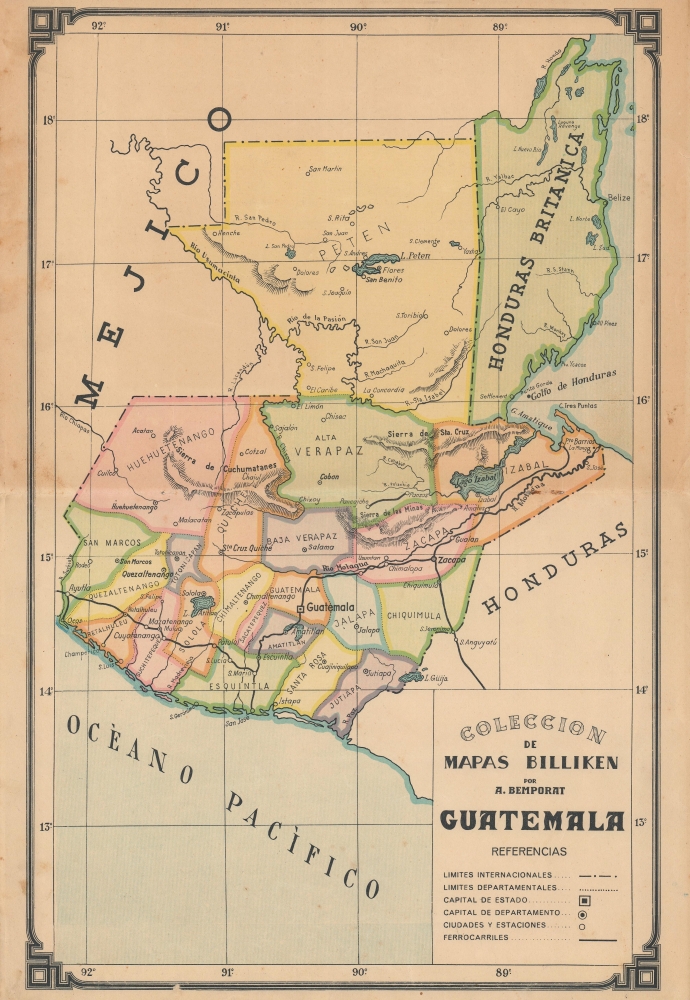
An attractive, colorful c. 1930 map of Guatemala produced by the Argentinian map publisher Bemporat as part of its Coleccion de Mapas Billiken. Aside from its aesthetic qualities, it is notable for referring implicitly the ongoing territorial dispute with Great Britain over British Honduras, future Belize.
A Closer Look
The entirety of Guatemala as well as British Honduras are displayed, along with neighboring portions of Mexico and Honduras. Individual departamentos are shaded different colors to easily distinguish them and have their capital cities noted. Other cities, railways, waterways, and mountains are also indicated. Latitude and longitude lines form a grid overlying the map.British Honduras Territorial Dispute
The inclusion of British Honduras is not merely incidental; Guatemala claimed the territory as one of its own departamentos from the mid-19th century. An 1859 treaty seemingly settled the issue, but the deal was contingent upon Britain building a road from the Caribbean to Guatemala, which failed to materialize after difficult negotiations. The issue became contentious again in the 1930s and remained so for much of the 20th century, through the independence of Belize, with Guatemala occasionally threatening invasion. In recent years, the dispute has continued through mediation and is currently before the International Court of Justice.United Fruit Company
Around the time this map was published, U.S. companies, especially the United Fruit Company, played a dominant role in the Guatemalan economy. The country's rail infrastructure, especially the line to Puerto Barrios, was built with the export of agricultural goods in mind and in the early 20th century came under United Fruit ownership (via its subsidiary the International Railways of Central America). The company also managed the country's postal service, paid no taxes, and was the largest landholder in Guatemala.Publication History and Census
This map was produced by the Argentinian map publisher Bemporat as part of its series Coleccion de Mapas Billiken. From the railways present, the map must date from after 1908, and the inclusion of British Honduras suggests a date around 1930, when the dispute reignited after lying mostly dormant for several decades. It does not appear in the OCLC and has no known history on the market.Cartographer
Aquiles Bemporat (1869 - September 22, 1957) was an Argentine-Italian cartographer and map publisher based in Buenos Aires. He was born in Trieste, Italy and emigrated to Buenos Aires sometime in the late 1870-80s, when he was a child. His firm, Oficina Cartográfica Bemporat, was founded around 1910 and remained active until at least 1960. Bemporat himself is elusive, despite a significant publication corpus. His map c. 1915 map of Buenos Aires won a gold medal at the 1915 San Francisco Exposition Universal. A 1949 CIA analysis of his work suggested that most of the map compilation was done in house by Bemporat himself, then over 70, and printed locally by network of small independent printers. The CIA report ultimately dismissed his maps as 'insufficiently accurate for intelligence use.' Nonetheless, Bemporat's work was highly decorative and enjoyed a strong local and international following, particularly in Latin America and Europe. He was widely admired for his longevity and continued to publish until his death at age 88. More by this mapmaker...
Condition
Very good. Original fold lines visible. Minor stains in margins.