This item has been sold, but you can get on the Waitlist to be notified if another example becomes available, or purchase a digital scan.
1894 Hassenstein Geological Map of Guatemala
Guatemala-hassenstein-1894$375.00

Title
Die Republik Guatemala Nach eigene Aufnahmen gezeiehnet von Dr. C. Sapper. Karte II: Geologische Übersicht.
1894 (dated) 24 x 21 in (60.96 x 53.34 cm) 1 : 900000
1894 (dated) 24 x 21 in (60.96 x 53.34 cm) 1 : 900000
Description
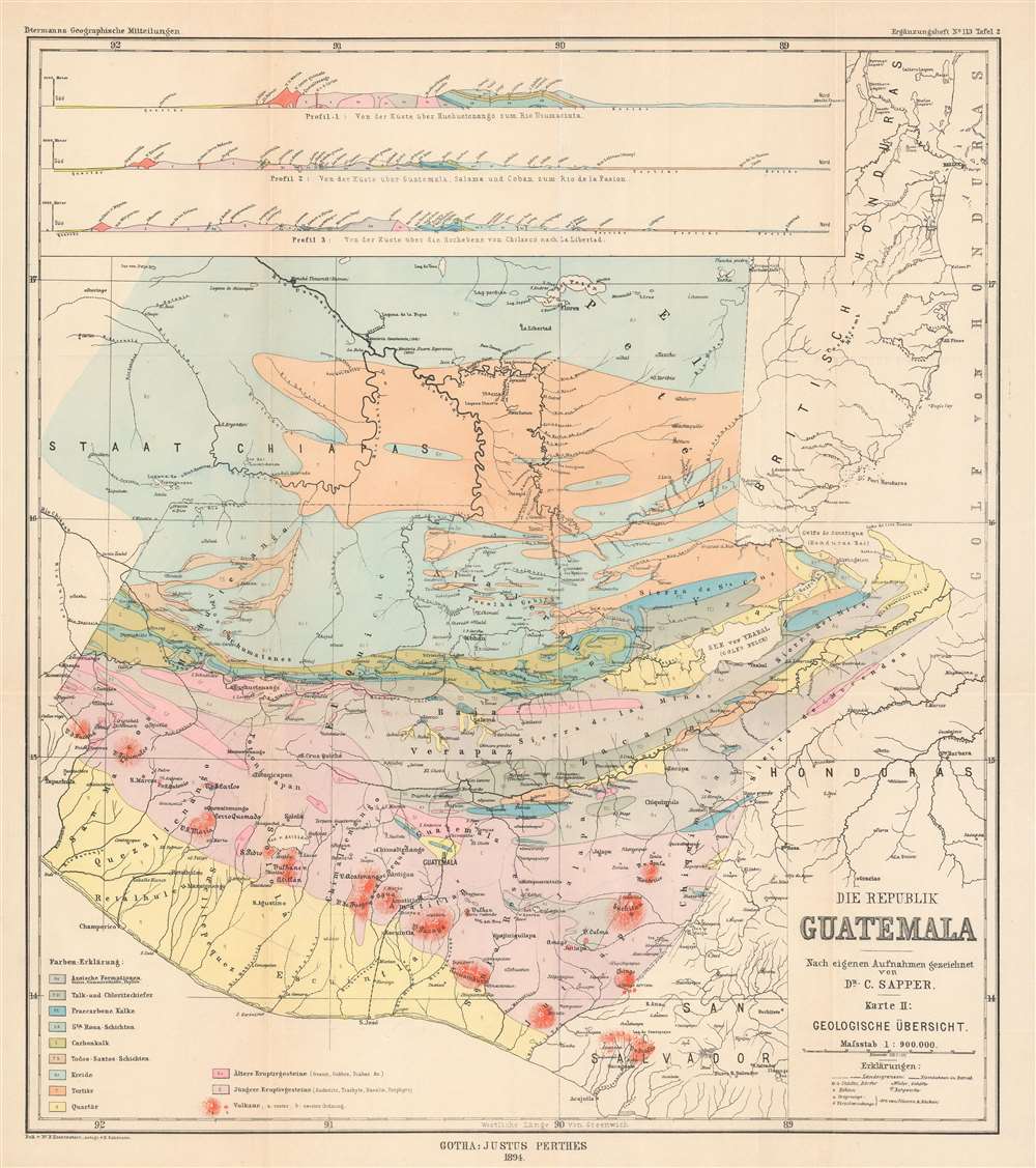
This is an 1894 Bruno Hassenstein geological map of Guatemala. Eleven different colors represent eleven different geological formations, including Azoic formations, formations of talc and chlorite slate, tertiary formations, quaternary formations, and older and younger igneous rock formations. A key situated in the lower left corner identifies which color corresponds with which formation, and small upper-case letters are used on the map to explicitly identify the color used in different sections of the map. Even small areas of each color are labeled, allowing for easy identification of the formations. Three profiles are situated along the top border and present this information from a much different perspective, allowing the viewer a better understanding of how rock formations create layers in the Earth's crust. The first profile illustrates an area 'from the coast via Huehuetenango to the Rio Usumacinta', while the second details a region 'from the coast via Guatemala, Salama and Coban to the Rio de la Pasion', and the third depicts an area from the coast over the Chilasco Plateau to La Libertad'.
Dr. Karl Sapper
Dr. Karl Theodor Sapper (February 6, 1866 - March 29, 1945) was a German explorer, linguist, traveler, and antiquarian known for his studies of the natural history, languages, and cultures of Central America at the turn of the 20th century. Between 1888 and 1895, Sapper traveled throughout Central America and over the course of his explorations published scientific works on an astounding array of subjects, including Mesoamerican languages, volcanology, and maps of Maya archaeological sites.Publication History and Census
This map was created and drawn by Bruno Hassenstein and engraved by Hubert Salzmann for publication by Justus Perthes in an 1894 edition of Petermanns Geographische Mitteilungen. The OCLC catalogs examples as being part of the institutional collections of The British Library, the Bavarian State Library in Munich, and the Central Library of Zurich. Examples are rare on the private market.Cartographer
Bruno Hassenstein (November 23, 1839 - August 27, 1902) was a German cartographer and was born in Ruhla, Thuringia. In 1854, Hassenstein began studying cartography and working under August Petermann in Gotha, founder of Petermanns Geographische Mitteilungen. Over the ensuing years, Hassenstein drew numerous maps for Petermanns Geographische Mitteilungen before relocating to Berlin in 1866 to work for another cartographer, including Karl Klaus von der Decken. He returned to Gotha two years later and works on maps for Henrich Theodor Menke's edition of Spurner's atlas of medieval history. He became editor of the cartography section of the Mittellungen in 1878 and worked on the Atlas von Japan, which was published in 1885. The University of Göttingen awarded him an honorary doctorate in 1878. More by this mapmaker...
Condition
Very good. Light wear along original fold lines. Verso repairs to fold separations and at fold intersections. Blank on verso.
References
OCLC 163822296.