1775 Treskot Map of Western Siberia, Russian Empire
GuberniiSibiriensis-treskot-1775$1,000.00

Title
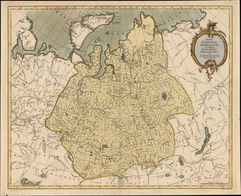
Mappa Gubernii Sibiriensis, continens procincias Toboliensem et Jenisejensem.
1775 (undated) 18 x 22 in (45.72 x 55.88 cm) 1 : 6313130
1775 (undated) 18 x 22 in (45.72 x 55.88 cm) 1 : 6313130
Description
A remarkable c. 1775 separately-issued map of the Siberia Governorate (guberniya) in western Siberia by Ivan Treskot. This map was part of a 1770 - 1776 project by Treskot and Jacob Friedrich Schmidt to map Siberia.
Beyond the borders of the governorate are Arkhangelsk, Kazan, and Orenberg at left, and Irkutsk and Ulan-Ude at right. The island of Novaya Zemlya, still largely unmapped at this time, is included at top. The Aral Sea appears at bottom left and Lake Baikal at bottom right. The border between Russia and the Qing Empire was fixed according to the 1727 Treaty of Kyakhta, signed at the settlement here written as 'Kjachtinskaja,' supplementing the earlier Treaty of Nerchinsk, which delineated their eastern border.
A Closer Look
The Siberia Governorate (shaded yellow) and its surroundings are displayed, with the governorate divided into the provinces of Tobolsk and Yeniseysk. The vastness of Siberia is on full display, stretching from the Arctic Ocean to Central Asia. In addition to Russia, portions of modern-day Kazakhstan and Mongolia are included. The large river systems of this portion of Siberia - the Irtysh, Ob, and Yenesei Rivers - stand out prominently, with dozens and dozens of tributaries noted, perhaps the most significant advancement provided by Treskot and Schmidt's mapping. Given the lack of roads, thick forests, and other obstacles, these rivers were Siberia's primary arteries of travel and trade. Cities, forts, missions, and other settlements are indicated, many of them shaded red, including Omsk, Tyumen, Tobolsk, Yekaterinburg, Tomsk, Obdorsk (now Salekhard), Beryozovo, Yeniseysk, and Krasnoyarsk.Beyond the borders of the governorate are Arkhangelsk, Kazan, and Orenberg at left, and Irkutsk and Ulan-Ude at right. The island of Novaya Zemlya, still largely unmapped at this time, is included at top. The Aral Sea appears at bottom left and Lake Baikal at bottom right. The border between Russia and the Qing Empire was fixed according to the 1727 Treaty of Kyakhta, signed at the settlement here written as 'Kjachtinskaja,' supplementing the earlier Treaty of Nerchinsk, which delineated their eastern border.
Pugachev's Rebellion and its Aftermath
The Siberia Governorate was split up not long after this map's publication, being divided into the Tobolsk and Kolyvan Viceroyalies, part of a wider administrative reorganization. These administrative reforms were largely motivated by Pugachev's Rebellion, which roiled a vast region from the Caspian Sea to Yekaterinburg between 1773 and 1775, including a significant battle at Kazan in July 1774. Although there were multiple factors, the rebellion was motivated by the diminished status of Cossacks, the peasantry in the reign of Catherine the Great, including greater empowerment of the nobility and increased taxes. Non-Russian ethnicities were also angered by a growing imperial presence, including attempts to seize more land and forcibly convert them to Christianity. By some accounts, Pugachev's Rebellion was the largest peasant uprising in Russian history, and it clearly signaled the transition from an early modern form of political economy on the Russian frontier towards the modern imperial state.Publication History and Census
This map was prepared by Ivan (Johann) Fomic Treskot (Иван Фомич Трускотт) and engraved around 1775 by Kirill Fedorovich Frolov (Кирилл Федорович Фролов; 1748 - 1810). It is quite rare - we note examples at Harvard University, the Russian State Library, University Library Göttingen, Biblioteca Nacional de España, the National Maritime Museum (U.K., as part of the map collection of William Wyndham Grenville), the Universitätsbibliothek Bern, and the National Library of Finland (as part of the Adolf Erik Nordenskiöld map collection). There is an especially rare alternate printing with an ornate border held by the Russian State Library, which lists Ivan Kuvakin (Иван Кувакинъ, 1751 - 1809) as the engraver. Another edition of the map, identical except for the title and border, is titled 'Map of the Siberian Provinces, Containing the Provinces of Tobolsk and Yeniseysk' (Карта Сибирской губернии, содержащая в себе Тобольскую и Енисейскую провинции); it maintains the border of the alternate printing and also lists Kuvakin as engraver.CartographerS
Ivan (Johann) Fomic Treskot (Иван Фомич Трускотт; December 1, 1721 - May 18, 1786), also spelled Treskott, Truscott, or Truskot, was a Russian cartographer active in St. Petersburg in the late 18th century. Treskot was born in St. Peterburg, the son of an English merchant (perhaps the reason his name is sometimes recorded as John Truskott). He studied architecture and cartography at the Russian Academy of Sciences under Joseph-Nicolas De l'isle (April 4, 1688 – September 11, 1768) and Jacob Friedrich Schmidt (Якоб Фридрих Шмидт; 1723 - 1786). In 1746 he was made head of the Cartographic Department at the St. Petersburg Academy of Sciences. They went on to compile a detailed mapping of Siberia, publishing various regional maps from 1770 to 1776. Working with Schmidt, Treskot compiled the 1784 Tabula Geographica Generalis Imperii Russici, the finest general map of the empire since after the 1734 Kirilov. Treskot was active at the Russian Academy's Geographical Department for nearly 50 years, from 1737 to his death in 1786. While he supervised the construction of hundreds of maps, only 11 of which bear his imprint. More by this mapmaker...
Kirill Fedorovich Frolov (Кирилл Федорович Фролов; 1748 - November 18, 1810) was a Russian copper plate engraver serving the Russian Academy of Sciences at St. Petersburg. Frolov studied draftsmanship, painting, and engraving under the well known master engraver Mikhail Ivanovich Makhaev (Михаи́л Ива́нович Маха́ев; 1718 - 172). His two sons Nikolai (1795 - ?) and Semyon, were also engravers. Learn More...
Condition
Good. Light wear along original centerfold. Slight discoloration in upper quadrant. Mild foxing and soiling. Several small tears around border professionally repaired.
References
OCLC 936633603.