1793 Stedman / Conder Map of Guiana
Guiana-stedmanjohng-1793$850.00

Title
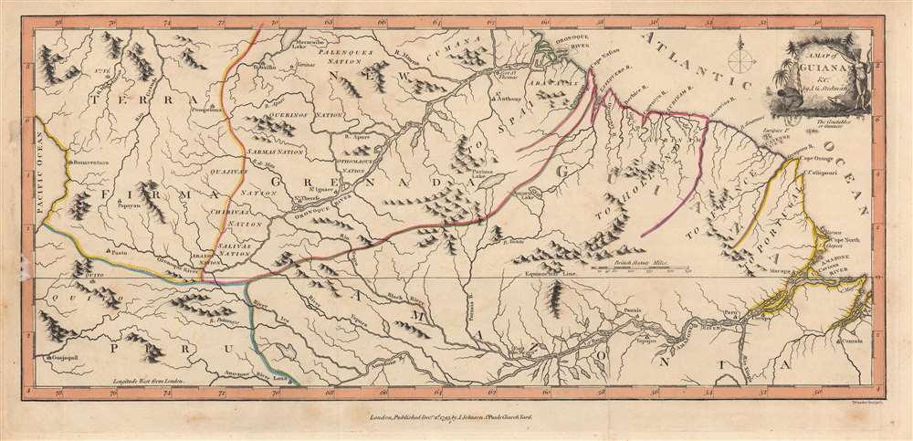
A Map of Guiana etc.
1793 (dated) 7.75 x 17 in (19.685 x 43.18 cm) 1 : 8000000
1793 (dated) 7.75 x 17 in (19.685 x 43.18 cm) 1 : 8000000
Description
This is a significant 1793 map of Guiana by John Gabriel Stedman and Thomas Conder, published to accompany Stedman's The Narrative of a Five Years Expedition against the Revolted Negroes of Surinam. Although parts of this region were claimed by European powers and Europeans resided near the coast, trading and managing plantations, the geography, climate, and peoples of the interior were poorly understood when this map was published.
This map and Stedman's Narrative dealt with a region that was still quite mysterious to Europeans in the late 18th century. Though the coastlands had been well mapped early in the 16th century, the interior was rarely penetrated. The combination of mountainous terrain, daunting jungles, malaria, and potential attack by indigenous groups and maroon guerillas combined to make this area all but unexplorable.
Likely in the recent past, a large lake did exist here near permanently. Brazilian geologists Gert Woeltje and Frederico Guimarães Cruz along with Roland Stevenson found that on the hillsides encircling the area, a horizontal line can be seen at a uniform level approximately 120 metres (390 ft) above sea level.[50] He proposed that this line represents the water level of an extinct lake that existed until recent times. Researchers who studied it found that the lake's previous diameter measured 400 kilometres (250 mi) and its area was about 80,000 square kilometres (31,000 sq mi). About 700 years ago this giant lake began to drain due to epeirogenic movement.In June 1690, a massive earthquake opened a bedrock fault, forming a rift or a graben that permitted the water to flow into the Rio Branco. By the early 19th century it had dried up completely.
Stedman took copious notes on everything he saw, down to the flora, fauna, and smells of Suriname, allowing him to craft a detailed narrative after his return to the Netherlands (though he sanitized unflattering details of his own life). The resulting book gave readers a feeling of immersion in an exotic environment, which provided a surreal contrast alongside equally vivid descriptions of disease, torture, and death. As if to highlight this dichotomy, the cartouche at top-right shows an African suffering in chains and an Amerindian warrior figure in the midst of a lush wilderness.
The book became very popular for its rich portrayal of a region little known in Europe and was quickly translated into multiple languages. It was circulated widely among the burgeoning abolitionist movement, with the love story between Stedman and Joanna being retold and embellished, with Joanna becoming something of a heroine for the movement.
A Closer Look
The map depicts the region of Guiana with hand-colored borders, encompassing the modern countries and territories of Guyana, Suriname, and French Guiana, as well as portions of Brazil and Venezuela. More specifically, the area noted as 'To Spain' (New Granada) is today the eastern portion of Venezuela, the southern portion of what is here listed as 'To Holland' is the modern country of Suriname, while the southern portion (the provinces of Essequibo, Berbice, and Demerara) were captured by the British during the Napoleonic Wars, becoming British Guyana and later the independent country of Guyana. The area marked here as 'To France' was and remains French Guiana while the lands denoted as 'To Portugal' are now the State of Amapá in Brazil.This map and Stedman's Narrative dealt with a region that was still quite mysterious to Europeans in the late 18th century. Though the coastlands had been well mapped early in the 16th century, the interior was rarely penetrated. The combination of mountainous terrain, daunting jungles, malaria, and potential attack by indigenous groups and maroon guerillas combined to make this area all but unexplorable.
Lake Parima: Still Searching for El Dorado
One interesting aspect of this map is Stedman's retention of the Lake Parima, located near center. Lake Parima was first identified by Sir Walter Raleigh in the 16th century - though he admittedly never saw the lake himself. Raleigh associated the lake with indigenous legends of Manoa and the supposed site of El Dorado (many early maps show 'El Dorado' on the shores of Lake Parima). The Manoa were a river trading tribe based in the Amazon. Each year during the rainy season, flooding on the Orinoco and Parima rivers would create a large flood plain and open channels of trade between the two otherwise unconnected regions. Raleigh misinterpreted indigenous descriptions of these watery trade channels as a great lake.Likely in the recent past, a large lake did exist here near permanently. Brazilian geologists Gert Woeltje and Frederico Guimarães Cruz along with Roland Stevenson found that on the hillsides encircling the area, a horizontal line can be seen at a uniform level approximately 120 metres (390 ft) above sea level.[50] He proposed that this line represents the water level of an extinct lake that existed until recent times. Researchers who studied it found that the lake's previous diameter measured 400 kilometres (250 mi) and its area was about 80,000 square kilometres (31,000 sq mi). About 700 years ago this giant lake began to drain due to epeirogenic movement.In June 1690, a massive earthquake opened a bedrock fault, forming a rift or a graben that permitted the water to flow into the Rio Branco. By the early 19th century it had dried up completely.
Stedman's Narrative
As the son of an officer of the Scots Brigade that served in the Netherlands, Stedman was drawn to a military career from a young age. He joined a volunteer corps bound for Suriname to fight against units of maroons (escaped slaves), who successfully employed guerilla tactics dissimilar to the pitched battles of European warfare. In his four years in Suriname, Stedman only fought in one battle, spending the rest of the time contending with disease, fatigue, and the cruelties of both the Dutch military and plantation slavery. Although not philosophically opposed to slavery (he owned several slaves), Stedman was horrified by cruel methods employed on plantations. He also fell into a sustained (though not exclusive) romantic relationship with one of his slaves, named Joanna, with whom he had a son.Stedman took copious notes on everything he saw, down to the flora, fauna, and smells of Suriname, allowing him to craft a detailed narrative after his return to the Netherlands (though he sanitized unflattering details of his own life). The resulting book gave readers a feeling of immersion in an exotic environment, which provided a surreal contrast alongside equally vivid descriptions of disease, torture, and death. As if to highlight this dichotomy, the cartouche at top-right shows an African suffering in chains and an Amerindian warrior figure in the midst of a lush wilderness.
The book became very popular for its rich portrayal of a region little known in Europe and was quickly translated into multiple languages. It was circulated widely among the burgeoning abolitionist movement, with the love story between Stedman and Joanna being retold and embellished, with Joanna becoming something of a heroine for the movement.
Publication History and Census
This map was made by John Gabriel Stedman and engraved by Thomas Conder for The Narrative of a Five Years Expedition against the Revolted Negroes of Surinam, published in London by Joseph Johnson. The map is independently cataloged as being held by the British Library, the National Library of Scotland, the Newberry Library, Victoria University, the University of Toronto, and the Bibliotheek Universiteit van Amsterdam. It has no known history on the market.CartographerS
John Gabriel Stedman (1744 – March 7,1797) was a Dutch-Scottish soldier who fought in the Dutch army against groups of escaped slaves (maroons) in Suriname (Dutch Guyana) in the mid-1770s, the basis for a popular book The Narrative of a Five Years Expedition against the Revolted Negroes of Surinam. The book was published in London by Joseph Johnson, and greatly influenced the early abolitionist movement, especially when illustrations by William Blake were added depicting the horrific punishments meted out to slaves. More by this mapmaker...
Thomas Conder (1747 - June 1831) was an English map engraver and bookseller active in London during the late 17th and early 18th centuries. From his shop at 30 Bucklersbury, London, Conder produced a large corpus of maps and charts, usually in conjunction with other publishers of his day, including Wilkinson, Moore, Kitchin, and Walpole. Unfortunately few biographical facts regarding Conder's life have survived. Thomas Conder was succeeded by his son Josiah Conder who, despite being severely blinded by smallpox, followed in his father's footsteps as a bookseller and author of some renown. Learn More...
Joseph Johnson (November 15, 1738 – December 20, 1809) was a bookseller and publisher in London with a reputation for publishing controversial works by radical thinkers, including supporters of women's rights, abolitionists, and Dissenters. He also hosted weekly dinners at his house with unconventional thinkers that became a sort of salon for philosophical discussion, known as the 'Johnson Circle'. Johnson's embrace of radical ideas led him to publish works in support of the French Revolution (including critical appraisals of Edmund Burke's Reflections on the Revolution in France), which caused him to come under great pressure from the authorities. He was imprisoned in 1799 for seditious libel, after which he published less controversial works. Nevertheless, Johnson remained a very prominent publisher, perhaps the most prominent in London, for having recognized early the value of publishing inexpensive works for a wide readership. He is remembered particularly for promoting women writers, including Mary Wollstonecraft, Anna Laetitia Barbauld, and Priscilla Wakefield, at a time when they were generally neglected by the reading public. Learn More...
Source
Stedman, J. G., The Narrative of a Five Years Expedition against the Revolted Negroes of Surinam, (London: Joseph Johnson, 1796).
Condition
Very good. Fold line evident towards right-center. Area of damage in left-hand margin. Sporadic discolored spots, mostly in margins.
References
OCLC 71577004, 557628007, 316396587.