
This item below is out of stock, but another example (left) is available. To view the available item, click "Details."
Details
1885 Bulla Pictorial Tourist Map of Rome, Italy
1885 (undated) $750.00
1900 Bulla Pictorial Tourist Map of Rome, Italy
GuidaRoma-bulla-1900$475.00

Title
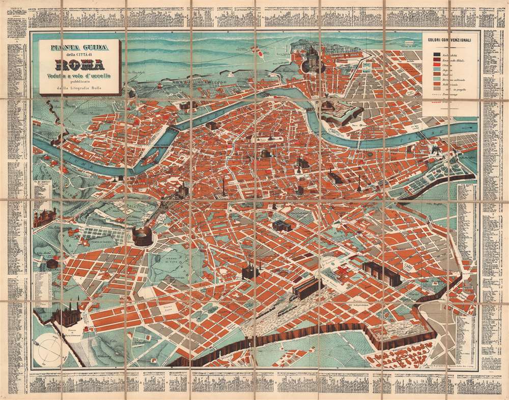
Pianta Guida della Città di Roma: Veduta a volo d'uccello.
1900 (dated) 17.25 x 23 in (43.815 x 58.42 cm)
1900 (dated) 17.25 x 23 in (43.815 x 58.42 cm)
Description
This is a scarce c. 1900 Romolo Bulla indexed pictorial bird's eye view of Rome, Italy. Oriented towards the west-southwest, it depicts Rome from the Aventine Hill to the Piazza del Popolo and the Villa Borghese, and from the Vatican to the Termini train station.
A key at top-right explains the color coding used on the map, for ancient structures, hotels and inns, churches, fountains, theaters, cultivated land, buildings used for manufacturing, and planned construction, as well as dashed lines for tramways and red dashed lines to mark out Rome's wards (rioni).
A Closer Look
Profile illustrations of most of the major monuments in Rome appear throughout, including the Colosseum, the Roman Forum, the Trevi Fountain, the Pantheon, the Temple of Vesta, and the Vatican, among others. All place names and street names are in Italian. An alphabetical street index appears just outside the border corresponding to a grid bordering the map, while indices at left give the location of famous lungoteveri, waterfront promenades along the Tiber, and for the quartiere Testaccio, an industrial area that mostly extended beyond the scope of this map.A key at top-right explains the color coding used on the map, for ancient structures, hotels and inns, churches, fountains, theaters, cultivated land, buildings used for manufacturing, and planned construction, as well as dashed lines for tramways and red dashed lines to mark out Rome's wards (rioni).
Publication History and Census
This map was created and published by Romolo Bulla c. 1900. Bulla published several editions of this map, all undated but most of which can be distinguished by the development of Rome's tramway system. We note some fifteen institutions holding any edition or state of this map. The present example is atypical in that it has been dissected and laid on linen for durability and foldability.Cartographer
François Bulla (fl. c. 1814 - 1855) was a French engraver, printmaker, lithographer, and printer. Born in Tessin, Bulla opened his business at 98, Rue du Temple around 1814 and moved to 38, Rue Saint-Jacques in 1821. Bulla published a catalog of his work in 1838 entitled Catalogue général des estampes et lithographies compost le fond de F. Bulla, éditeur, quaint Saint-Michel, 25 that was printed by the Imprimerie de Ducessois. Bulla's business was described in the Bazar Parisien in 1826 in this manner:
Possesses a considerable stock of prints in all formats. A print of Girodet's painting La bataille de la révolte du Caire stands out, along with allegorical and historical prints, as well as prints illustrating religious subjects. He accompanies these with a series of beautifully executed landscapes.The firm moved to Rome in 1840, establishing itself at 2 Via del Vantaggio not far from the Piazza del Popolo. In 1848, Bulla entered into a short-lived partnership with Cereghetti; he then moved on to a partnership with Stampa, a Spanish editor, in 1849. Bulla retired in 1855. Bulla had five sons: Eugène (known as Bulla ainé), Joseph, Antoine, Laurent, and Jean-Baptiste. All five of his sons would adopt their father's profession and become either editors or printers. His two oldest sons established their own firms. Antoine was sent by his father to Cadiz in 1849, but when François retired in 1855, Antoine took over his father's share of the partnership with Stampa. The firm still operates to this day in Rome, Italy and is owned by Bulla's descendants. More by this mapmaker...
Condition
Very good. Dissected and laid on linen. Small holes in corners suggest it was once hung.
References
OCLC 1230150687.