This item has been sold, but you can get on the Waitlist to be notified if another example becomes available, or purchase a digital scan.
1660 Jansson Map of West Africa (Gold Coast Slave Coast, Ivory Coast)
Guinea-jansson-1660$200.00

Title
Guinea.
1660 (undated) 16 x 21.5 in (40.64 x 54.61 cm) 1 : 6350000
1660 (undated) 16 x 21.5 in (40.64 x 54.61 cm) 1 : 6350000
Description
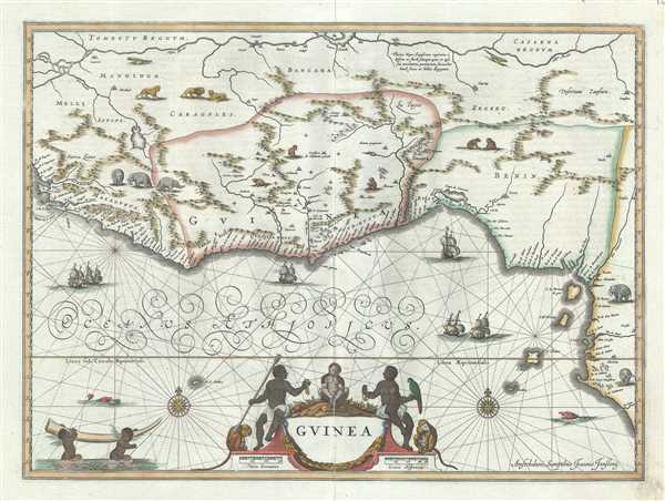
This is a rare and attractive c.1660 map of West Africa by Jan Jansson. It depicts the African Gold Coast, Ivory Coast and Slave Coast from Guinea south through the modern nations of Sierra Leone, Mali, Liberia, Burkina Faso, Cote D’Ivoire, Ghana, Togo, Nigeria, Cameroon, Equatorial Guinea and Gabon. Extends inland to include the Niger River. The coast is highly detailed. Here was can see the practice satirized by Jonathan Swift regarding the lack in information on the interior, they had to 'place elephants for want of towns.' Indeed the interior is decorated with stylized renderings of African animals including lions, elephants, cheetahs, and apes. On the water several sailing vessels are depicted. In the lower left an elaborate decorative Cartouche labeled the region simply Guinea. On the bottom left, two cherubic Africans haul a gigantic elephant tusk. This map was issued by Johannes Janssonius in his Atlas Novus.
Cartographer
Jan Jansson or Johannes Janssonius (1588 - 1664) was born in Arnhem, Holland. He was the son of a printer and bookseller and in 1612 married into the cartographically prominent Hondius family. Following his marriage he moved to Amsterdam where he worked as a book publisher. It was not until 1616 that Jansson produced his first maps, most of which were heavily influenced by Blaeu. In the mid 1630s Jansson partnered with his brother-in-law, Henricus Hondius, to produce his important work, the eleven volume Atlas Major. About this time, Jansson's name also begins to appear on Hondius reissues of notable Mercator/Hondius atlases. Jansson's last major work was his issue of the 1646 full edition of Jansson's English Country Maps. Following Jansson's death in 1664 the company was taken over by Jansson's brother-in-law Johannes Waesberger. Waesberger adopted the name of Jansonius and published a new Atlas Contractus in two volumes with Jansson's other son-in-law Elizée Weyerstraet with the imprint 'Joannis Janssonii haeredes' in 1666. These maps also refer to the firm of Janssonius-Waesbergius. The name of Moses Pitt, an English map publisher, was added to the Janssonius-Waesbergius imprint for maps printed in England for use in Pitt's English Atlas. More by this mapmaker...
Condition
Very good. Minor wear and verso repair along original centerfold. Original platemark visible. Minor spotting, especially along margins.