1716 Hermann Moll Map of West Africa
Guinea-moll-1716$250.00

Title
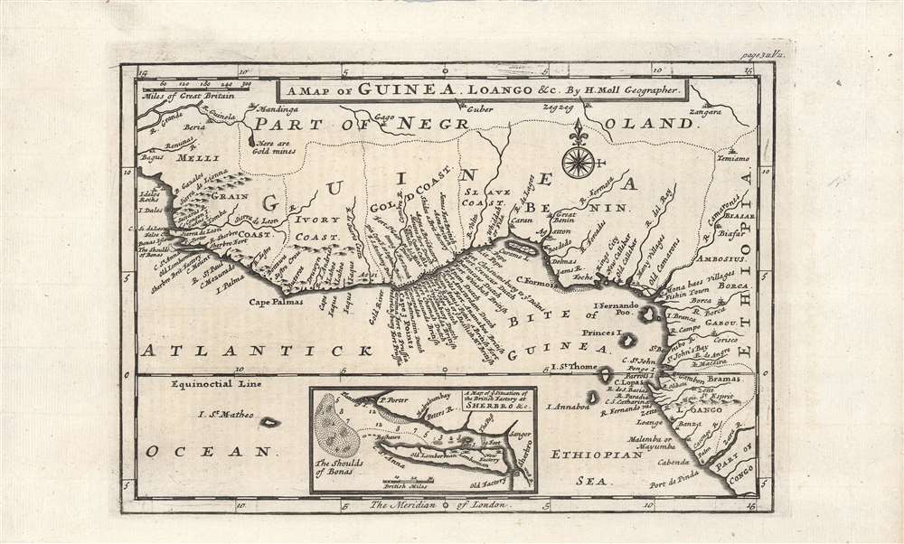
A map of Guinea, Loango etc.
1716 (undated) 6.5 x 9.75 in (16.51 x 24.765 cm) 1 : 11700000
1716 (undated) 6.5 x 9.75 in (16.51 x 24.765 cm) 1 : 11700000
Description
A nice example of Herman Moll's c. 1716 map of the 'Guinea Coast.' Coverage embraces most of the West African coast, from Mali to the Congo. It is an illustrative representation of the state of European geographic knowledge about Africa at the time, and the commercial concerns which motivated the search for said geographic knowledge.
A Closer Look
This map depicts the Gulf of Guinea and the West African coast from Mali (here as Melli) to the Congo or Zaire River (here as Zara). The most noticeable feature is the abundance of European fortresses and trading posts (factories) along the coast, especially on the Gold Coast. Rivers and islands are well-mapped, while information about the interior is cursory and speculative. Some areas are described simply, such as 'villages,' 'fishin' town,' and 'here are gold mines.' Scale is provided in English miles, while London serves as the Prime Meridian. Moll maintains 'Ethiopian Sea' for the South Atlantic, a convention which would disappear from maps in the 19th century.The Slave Trade
An inset map of Sherbro Island and surrounding waters is provided at bottom, with soundings and shoals marked out. This island was one of the main points of departure in the transatlantic slave trade in the early 18th century. The English created a monopoly (the Royal African Company) to manage trade with this part of Africa, but it was supplanted around the time of this map's production, creating a free-for-all among private traders that only increased the scale and brutality of the slave trade. After the British outlawed the slave trade in 1808, their facilities on the island were used for policing continued human trafficking. Later, the African American businessman Paul Cuffe developed a scheme to settle freedmen on the island, hoping that they would be able to dominate trade between the region and the new American Republic. The effort ran into difficulties but was an important precursor to the American Colonization Society and the foundation of Liberia.The Transatlantic Slave Trade
These coasts were first visited by Europeans when the Portuguese reached the area in the 15th century, after which they returned regularly to trade. Several sites along the coast, including the mouths of the Sierra Leone (here as Sierra de Leon), Sherbro, and Calabar (Callebar) Rivers, were the main locations of trade with Europeans. Although trade included various goods, as indicated by the naming of stretches of the coast (ivory, gold, grain), it was increasingly dominated by the slave trade by the 18th century.Publication History and Census
This map was prepared by Herman Moll, though its exact provenance is unclear. It was originally made for Moll's Atlas Geographus, published between 1711 - 1717, but the pagination here (page 311, Vol. II) rules out that work, as well as his Forty-two new maps of Asia, Africa, and America..., all engrav'd, according to the latest observations and Churchill's A Collection of voyages and travels. Perhaps due to its comprehensiveness regarding European trading posts, the map continued to be used in various publications throughout the 18th century. Regardless of the source, it is only cataloged independently in the holdings of four institutions and is scarce to the market.Cartographer
Herman Moll (1654 - 1732) was an important 18th century map publisher and engraver based in London and Holland. Moll's origins are disputed with some suggesting he was born in the Netherlands and others Germany - the Moll name was common in both countries during this period. Most likely Moll was a German from Bremen, as his will, friends, and contemporaries suggest. What is known for certain is that he moved to London in 1678, possibly fleeing the Scanian War, where he worked as an engraver for Moses Pitt and other London map publishers. Around the turn of the century, Moll set up his own shop where he produced a large corpus of work known for its high quality and decorative flair. As a new émigré to England, Moll made himself more English than the English, and through his cartography proved a fierce advocate for his adopted nation. Most of Moll's early maps were issued as loose sheets that would be bound to order, however, he did publish several important atlases late in his career. Moll is said to have made the bold claim that without a doubt "California is an Island" and that he "had in [his] office mariners who have sailed round it." While California may not be an island (yet), it is true that moll had talent for attracting interesting friends and acquaintances. He frequented London's first stock exchange, Jonathan's Coffeehouse at Number 20 Exchange Alley, Cornhill. At the time Jonathan's was known as "a place of very considerable concourse for Merchants, sea faring Men and other traders" (Erleigh, The Viscount, The South Sea Bubble, Manchester: Peter Davies, Ltd., 1933, 21). Eventually this activity attracted the interest of stock brokers, who inspired by sailor's tales, sponsored the ill-fated South Sea Company, the world's first stock bubble. Moll's close circle, mostly from the Coffee House, included scientist Robert Hooke, the writers Daniel Defoe (Robinson Crusoe) and Jonathan Swift (Gulliver's Travels), the pirates William Dampier, William Hacke and Woodes Rogers, and the archeologist William Stukeley. Herman Moll's work was highly regarded for its decorative beauty and was pirated, most notably by the Irish publisher George Grierson, both in his lifetime and after his 1732 death at St. Clement Danes, London. More by this mapmaker...
Condition
Very good.
References
OCLC 137360689, 316396814.