1728 d'Anville Map of Guinee, West Africa: Ghana, Togo, Benin
GuineeGhana-anville-1729$1,800.00

Title
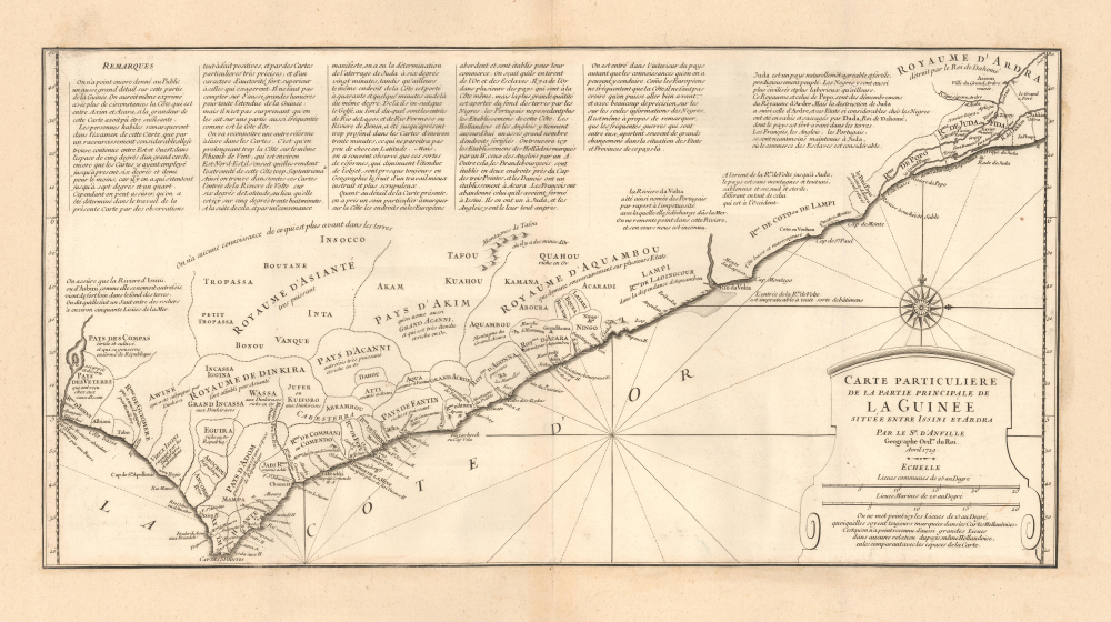
Carte Particuliere de la Partie Principale de la Guinée située entra Issini et Ardra.
1729 (dated) 13 x 23 in (33.02 x 58.42 cm) 1 : 1050000
1729 (dated) 13 x 23 in (33.02 x 58.42 cm) 1 : 1050000
Description
This is J. B. B. d'Anville's scarce, separately-issued 1729 map of 'Guinée', comprising the west African coast in what is today Ghana, Togo, and parts of Benin. Much of the region, when this map was made, was dominated by the slave-trading empire of Dahomey, which captured Whydah (here as Juda) at the eastern extreme of the map in 1729 - likely influencing the creation of this map. The capture of Whydah gave the warlike Dahomey access to European slave markets, placing them at the center of propagating the Atlantic Slave Trade.
A Closer Look
Coverage embraces a stretch of the West African coast that corresponds to today's Ghana, Togo, and Benin - roughly from Cape Three Points to modern-day Porto-Novo. D'Anville makes a strenuous effort to document the tribal kingdoms dominating the region, but admits to limited knowledge of the interior. British, Dutch, and some other trading posts - mostly dedicated to the slave trade - are noted. The map follows closely on the expansion through conquest of the Kingdom of Dahomey into Ardra (Allada, 1727) and Whydah (Juda, 1729).Dahomey and the Slave Trade
In 1729, the Kingdom of Dahomey, under King Agaja (r. 1718 - 1740), was at the height of its expansion and power in West Africa. Having conquered the neighboring state of Allada in 1727 and captured the vital coastal kingdom of Whydah in 1729, Dahomey gained direct access to European traders and became a major force in the transatlantic slave trade. Its centralized and militarized society, supported by a disciplined army that included female soldiers later renowned as the 'Amazons,' enabled it to dominate the region and supply enslaved captives in exchange for firearms, textiles, and other goods. While this brought immense wealth and influence, Dahomey's rise also provoked conflict, particularly with the powerful Oyo Empire to the east, which would soon curtail Dahomey's independence. Nonetheless, in 1729, Dahomey stood as one of the most aggressive and prosperous African states, built on conquest, tribute, and the Atlantic slave economy. D'Anvilles commentary on Dahomey is as follows,Juda est un pays naturellement agréable et fertile, prodigieusement peuplé. Les Nègres y sont aussi plus civilisés et plus laborieux qu’ailleurs. Ce Royaume, et celui de Popo, sont des démembrements du Royaume d’Ardre. Mais la destruction de Juda a suivi celle d’Ardre, et ces États si considérables chés les Nègres ont été envahis et saccagés par Dada, Roi de Dahomé, dont le pays est fort avant dans les terres. Les François, les Anglois, les Portugais, se sont neantmoins maintenus à Juda, où le commerce des Esclaves est considérable.
Juda is a naturally pleasant and fertile country, prodigiously populated. The Negroes there are also more civilized and more industrious than elsewhere. This kingdom and that of Popo are offshoots of the Kingdom of Ardra. But the destruction of Juda followed that of Ardra, and these states, so considerable among the Negroes, were invaded and plundered by Dada, King of Dahomey, whose country extends far inland. The French, the English, and the Portuguese nevertheless remain established at Juda, where the trade in slaves is considerable.
Fascinating Annotation
The map includes other extensive textual annotation reflecting d'Anville's dogged dedication to cartographic excellence. Our translation is below:The public has not yet been given such a detailed account of this part of Guinea. One might even have described in more detail the coast between Axim and Acara, if the size of this map had allowed it.
Skilled observers will note, upon examining this map, that by a considerable shortening, the area between east and west is contained within five degrees of a great circle, whereas earlier maps extended it to at least six and a half degrees, and in some cases even to seven. However, one can be certain that the present map is more accurate, having been based on entirely reliable observations and very precise charts of great authority, far superior to those that exaggerate. We must not rely on broad assumptions for the extent of Guinea, and it is not surprising that a more accurate view should be available for such a frequently traveled area as the Gold Coast.
Another correction in this map is the adjustment of the coastline along the same latitude, which previous maps extended too far east and west. This caused them to place the Volta River too far north, giving it a latitude of six degrees eighteen minutes, when in fact its mouth lies at six degrees twenty minutes. In other places, previous maps misplaced the coast by as much as forty minutes. Beyond the Gulf, at the entrance of the Rio Formoso or Benin River, maps remain vague and uncertain, giving little clarity in latitude.
It must be noted, however, that such corrections, while improving the extent of the coast, always remain subject to the careful work of the most scrupulous geographers.
This map also carefully records the European trading posts established along the coast. It is well known that they obtain gold and slaves here. Several European nations are present along this coast, but most of the trade is carried out by the Portuguese, who established the earliest posts. The Dutch and English are now the most powerful, having built several fortified posts. Among these, the Dutch establishments are marked with an 'H,' and those of the English with an 'A.' In addition, the Brandenburgers hold two posts on Cape Three Points, the Danes at Accra, and the French formerly had a post at Assinie.
The Europeans have only ventured inland as far as their knowledge allowed. Since they only frequent the coast, it should not be believed that they could penetrate further with accuracy, relying only on the reports of the Africans. It is worth noting as well that the frequent wars among the local peoples often bring great changes in the state and provinces of this country.
Publication History and Census
This map was separately-published by J. B. B. d'Anville in 1729. It is scarce. We note a few examples in OCLC, but the proliferation of digital copies, proliferated from the Bibliothèque Nationale de France, makes a comprehensive census nearly impossible. Rare.Cartographer
Jean Baptiste Bourguignon d'Anville (1697 - 1782) was perhaps the most important and prolific cartographer of the 18th century. D'Anville's passion for cartography manifested during his school years when he amused himself by composing maps for Latin texts. There is a preserved manuscript dating to 1712, Graecia Vetus, which may be his earliest surviving map - he was only 15 when he drew it. He would retain an interest in the cartography of antiquity throughout his long career and published numerous atlases to focusing on the ancient world. At twenty-two D'Anville, sponsored by the Duke of Orleans, was appointed Geographer to the King of France. As both a cartographer and a geographer, he instituted a reform in the general practice of cartography. Unlike most period cartographers, D'Anville did not rely exclusively on earlier maps to inform his work, rather he based his maps on intense study and research. His maps were thus the most accurate and comprehensive of his period - truly the first modern maps. Thomas Basset and Philip Porter write: "It was because of D'Anville's resolve to depict only those features which could be proven to be true that his maps are often said to represent a scientific reformation in cartography." (The Journal of African History, Vol. 32, No. 3 (1991), pp. 367-413). In 1754, when D'Anville turned 57 and had reached the height of his career, he was elected to the Academie des Inscriptions. Later, at 76, following the death of Philippe Buache, D'Anville was appointed to both of the coveted positions Buache held: Premier Geographe du Roi, and Adjoint-Geographer of the Academie des Sciences. During his long career D'Anville published some 211 maps as well as 78 treatises on geography. D'Anville's vast reference library, consisting of over 9000 volumes, was acquired by the French government in 1779 and became the basis of the Depot Geographique - though D'Anville retained physical possession his death in 1782. Remarkably almost all of D'Anville's maps were produced by his own hand. His published maps, most of which were engraved by Guillaume de la Haye, are known to be near exact reproductions of D'Anville' manuscripts. The borders as well as the decorative cartouche work present on many of his maps were produced by his brother Hubert-Francois Bourguignon Gravelot. The work of D'Anville thus marked a transitional point in the history of cartography and opened the way to the maps of English cartographers Cary, Thomson and Pinkerton in the early 19th century. More by this mapmaker...
Condition
Very good. Trimmed to neatline and laid down on contemporary laid paper - likely to fit a composite atlas.
References
Bibliothèque Nationale de France, Département Arsenal, EST-1503 (30). OCLC 1249229871.