1863 Admiralty Chart of Waters Off Burma, Andaman Sea, Gulf of Martaban
GulfofBengalVII-admiralty-1863$550.00

Title
Gulf of Bengal Sheet VII Bassein, Rangoon, Martaban Compiled from various Surveys...
1863 (dated) 20 x 26 in (50.8 x 66.04 cm) 1 : 700000
1863 (dated) 20 x 26 in (50.8 x 66.04 cm) 1 : 700000
Description
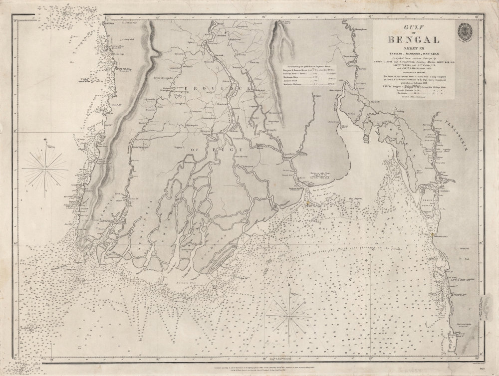
A scarce 1863 British Admiralty chart of the waters off the coast of Burma (now Myanmar), focusing on the Irrawaddy River Delta, the Andaman Sea, and the Gulf of Martaban. It was produced following the Second Anglo-Burmese War (1852 - 1853), when the British took control of the region.
Out at sea, soundings proliferate (some handwritten), with islands, rocks, shoals, reefs, and hazards noted. Much of the coastline consisted of flats that could be dry, muddy, or submerged depending on the season, presenting a problem for larger ships in particular. Descriptive notes appear throughout, such as the area marked 'very dangerous' near the mouth of the Sittaung River. Small touches of color represent the lightship at the mouth of the Rangoon River (about which an explanatory note is provided nearby) and the Amherst Lighthouse towards bottom-right. Two elaborate compass roses with variations appear at left and bottom-center.
A Closer Look
Coverage stretches from Gwa around to the Sittaung River and through Martaban (now Mottama). Rangoon (Yangon) is located near center while Bassein (Pathein) is towards left and Pegu (Bago) is northeast of Rangoon. Aside from cities, pagodas and other landmarks useful for navigation are recorded. Several rivers flow out into the sea near center, most of which are branches of the Irrawaddy (Ayeyarwady), while other river systems connected to the Bassein, Sittaung, and Salween Rivers are depicted in great detail.Out at sea, soundings proliferate (some handwritten), with islands, rocks, shoals, reefs, and hazards noted. Much of the coastline consisted of flats that could be dry, muddy, or submerged depending on the season, presenting a problem for larger ships in particular. Descriptive notes appear throughout, such as the area marked 'very dangerous' near the mouth of the Sittaung River. Small touches of color represent the lightship at the mouth of the Rangoon River (about which an explanatory note is provided nearby) and the Amherst Lighthouse towards bottom-right. Two elaborate compass roses with variations appear at left and bottom-center.
Publication History and Census
This chart was published by the Hydrographic Office of the British Admiralty in 1863, based on a chart dating to 1835. It was engraved by John and Charles Walker, a firm that regularly engraved charts for the Admiralty. As indicated in a box to the left of the title, it was one of a series of charts dealing with the Burmese coast. This chart is quite rare, only being held by the National Maritime Museum in Greenwich and only appearing once on the market in recent years.CartographerS
The British Admiralty Office (1795 - Present) or the United Kingdom Hydrographic Office refers to the Branch of the English government that is responsible for the command of the British Navy. In 1795 King George III created the United Kingdom Hydrographic Office, known in short as the U.K.H.O., to provide top notch nautical charts to the vast Royal Navy. Prior the founding of the Admiralty the surveying and creation of nautical charts was primarily a commercial venture wherein the cartographer himself, more of than not, actually financed the printing of his own material. The great navigator Cook himself is known to have scrambled for funds to publish his own seminal charts - the most important and advanced of the period. The system of privately funded nautical mapping and publishing left vast portions of the world uncharted and many excellent charts unpublished. King George III, responding significant loss in trade revenue related to shipwrecks and delay due to poor charts, recognized the need for an institutionalized government sponsored cartographic agency - the Admiralty. The first head of the Admiralty, a position known as Hydrographer, was the important cartographer Alexander Dalrymple. Dalrymple started by organizing and cataloging obtainable charts before initiating the laborious process of updating them and filling in the blanks. The first official Admiralty Chart appeared in 1800 and detailed Quiberon Bay in Brittany. By 1808 the position of Hydrographer fell to Captain Thomas Hurd. Hurd advocated the sale of Admiralty charts to the general public and, by the time he retired in 1829, had issued and published some 736 charts. Stewardship of the organization then passed to Rear Admiral Sir Francis Beaufort. It was under Beaufort's administration that the Admiralty truly developed as a "chart making" as opposed to a "chart cataloging" institution. Beaufort held his post from 1829 to 1854. In his 25 years at the Admiralty Beaufort created nearly 1500 new charts and sponsored countless surveying and scientific expeditions - including the 1831 to 1836 voyage of the H.M.S. Beagle. By 1855 the Admiralty's chart catalog listed some 1,981 charts. More by this mapmaker...
John Walker (1787 - April 19, 1873) was a British map seller, engraver, lithographer, hydrographer, geographer, draughtsman, and publisher active in London during the 19th century. Walker published both nautical charts and geographical maps. His nautical work is particularly distinguished as he was an official hydrographer for the British East India Company, a position, incidentally, also held by his father of the same name. Walker's maps, mostly published after 1827, were primarily produced with his brothers Charles Walker and Alexander Walker under the imprint J. and C. Walker. Among their joint projects are more than 200 maps for the influential Society for the Diffusion of Useful Knowledge Atlas (SDUK). In addition they published numerous charts for James Horsburgh and the British Admiralty Hydrographic Office, including Belcher's important map of Hong Kong and Carless' exploratory map of Karachi. The J. and C. Walker firm continued to publish after both Walkers died in the 1870s. Learn More...
Condition
Good. Soiling, creasing, and wear confined to the margins.
References
Royal Museums Greenwich ID G255:6/4.