This item has been sold, but you can get on the Waitlist to be notified if another example becomes available, or purchase a digital scan.
1750 Bellin Map of Cape Town, South Africa
Gundriss-bellin-1750$115.00

Title
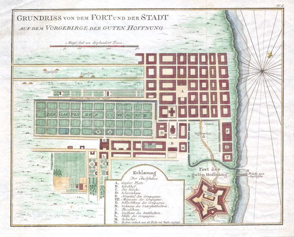
GRUNDRISS VON DEM FORT UND DER STADT AUF DEM VORGEBIRGE DER GUTEN HOFFNUNG.(Plan of the fort and the town on the promontory of Good Hope)
1750 8.5 x 10.5 in (21.59 x 26.67 cm)
1750 8.5 x 10.5 in (21.59 x 26.67 cm)
Description
Featured here is a rare c. 1750 map of Cape Town, South Africa, by the French cartographer Jacques-Nicholas Bellin. Map depicts the city and for of Cape Town in considerable detail with particular emphasis on the identifications of individual buildings and gardens. Text is printed in German and French.
Cartographer
Jacques-Nicolas Bellin (1703 - March 21, 1772) was one of the most important cartographers of the 18th century. With a career spanning some 50 years, Bellin is best understood as geographe de cabinet and transitional mapmaker spanning the gap between 18th and early-19th century cartographic styles. His long career as Hydrographer and Ingénieur Hydrographe at the French Dépôt des cartes et plans de la Marine resulted in hundreds of high quality nautical charts of practically everywhere in the world. A true child of the Enlightenment Era, Bellin's work focuses on function and accuracy tending in the process to be less decorative than the earlier 17th and 18th century cartographic work. Unlike many of his contemporaries, Bellin was always careful to cite his references and his scholarly corpus consists of over 1400 articles on geography prepared for Diderot's Encyclopedie. Bellin, despite his extraordinary success, may not have enjoyed his work, which is described as "long, unpleasant, and hard." In addition to numerous maps and charts published during his lifetime, many of Bellin's maps were updated (or not) and published posthumously. He was succeeded as Ingénieur Hydrographe by his student, also a prolific and influential cartographer, Rigobert Bonne. More by this mapmaker...
Condition
Very good condition. Minor watermark in the upper left margin. Else clean. Contemporary hand color. Original platemark visible. Wide clean margins. Blank on verso.