This item has been sold, but you can get on the Waitlist to be notified if another example becomes available, or purchase a digital scan.
1695 / 1781 Abraham bar Yaaqov Hebrew Map of the Holy Land and Haggadah
HaggadahMap-yaaqov-1695$2,250.00

Title
Seder Haggadah Shel Pasah.
1695 (dated) 10 x 18.75 in (25.4 x 47.625 cm)
1695 (dated) 10 x 18.75 in (25.4 x 47.625 cm)
Description
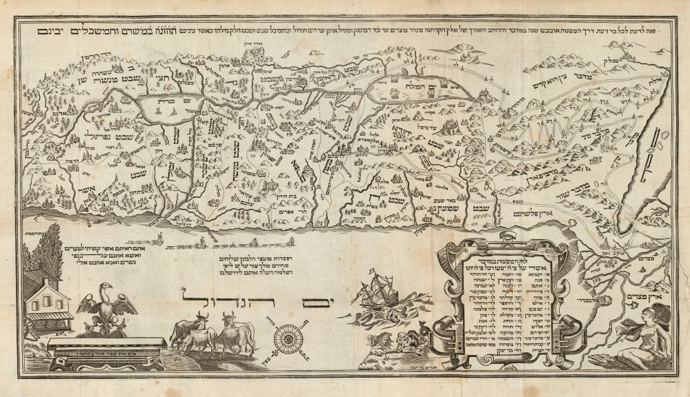
This is Abraham bar Yaaqov's 1695 map of the Holy Land - the first acquirable such map in Hebrew. It stands distinct from most other Holy Land maps produced in the 17th century, not only in its Hebrew text, but also the map's iconography which adheres to themes from the Torah, applying specifically to the Passover story. It was printed to accompany the famous Amsterdam Haggadah, the most lavishly illustrated printed Haggadah to date. Both thematically and aesthetically, it would set the standard for printed Haggadot to follow.
A key element is the track of the Peregrination: the route taken by the Israelites out of Egypt during the Exodus. The distinctive zig-zag path depicted here reveals Adrichem as the ultimate source for this map (likewise the depiction of the Dead Sea with the destroyed cities of Sodom and Gomorrah). The Bar Yaaqov's correct orientation of the Egyptian coastline suggests that his immediate source for Adrichem's geography actually derived from Hondius' 1633 map, which corrected Adrichem's coastline. The lower right corner is decorated with a woman with a parasol astride a crocodile: this is the allegory of Africa, included to emphasize the correction to the coastline, and the continent to which Egypt belongs.
Bar Yaaqov includes a further path that appears to be unique to this map: in addition to the path of the Exodus, a path is shown from Hebron to Goshen, the route taken by the family of Jacob to Egypt. Thae direction of travel is emphasized by the inclusion of an ox-drawn cart following the path to the south. The meaning here is that the Exodus is not so much an escape, as a homecoming.
The eagle at lower left is representative of G_d's protection of the Israelites; the barn full of beehives and the cluster of cattle symbolize the milk and honey of the Promised Land. Also in the sea, a flotilla of ships transports barges of Lebanon cedar for the construction of the Temple of Solomon. This is an element drawn from Nicolas Visscher's 1659 map of the Holy Land which included a reference to Kings 5.9, in which King Hiram agrees to Solomon's request for timber for the construction of the Temple and describes his plan to deliver the cedars by sea.
Haggadot were meant to be used anually at the Seder Table, with the inevitable result that they show significant wear: wine and food stains are to be expected.
The Map's Sources
Bar Yaaqov's map is one of the only early maps of the Holy Land printed in Hebrew. It is largely thought to be a translation of Christian van Adrichem's 1590 map, which for many years represented the standard for the Biblical mapping. However, study of the map shows evidence of its having been composed consulting a variety of maps, with both the geographical and the decorative elements carefully chosen to illustrate the lessons of the Passover.A key element is the track of the Peregrination: the route taken by the Israelites out of Egypt during the Exodus. The distinctive zig-zag path depicted here reveals Adrichem as the ultimate source for this map (likewise the depiction of the Dead Sea with the destroyed cities of Sodom and Gomorrah). The Bar Yaaqov's correct orientation of the Egyptian coastline suggests that his immediate source for Adrichem's geography actually derived from Hondius' 1633 map, which corrected Adrichem's coastline. The lower right corner is decorated with a woman with a parasol astride a crocodile: this is the allegory of Africa, included to emphasize the correction to the coastline, and the continent to which Egypt belongs.
Bar Yaaqov includes a further path that appears to be unique to this map: in addition to the path of the Exodus, a path is shown from Hebron to Goshen, the route taken by the family of Jacob to Egypt. Thae direction of travel is emphasized by the inclusion of an ox-drawn cart following the path to the south. The meaning here is that the Exodus is not so much an escape, as a homecoming.
Rich Allegorical Elements
In the waters of the Mediterranean, Jonah is shown being cast overboard to the whale - an image that appears many times on Holy Land maps based on Adrichem. This particular vignette closely resembles the same scene drawn from the 1633 Hondius. In contrast with other maps, Bar Yaaqov also includes the conclusion of that story, in which Jonah is spat onto the shores of Nineveh, revealing his encounter with the whale not to be Jonah's doom, but his divine deliverance.The eagle at lower left is representative of G_d's protection of the Israelites; the barn full of beehives and the cluster of cattle symbolize the milk and honey of the Promised Land. Also in the sea, a flotilla of ships transports barges of Lebanon cedar for the construction of the Temple of Solomon. This is an element drawn from Nicolas Visscher's 1659 map of the Holy Land which included a reference to Kings 5.9, in which King Hiram agrees to Solomon's request for timber for the construction of the Temple and describes his plan to deliver the cedars by sea.
The Amsterdam Haggadah
At the time Seder Haggadah Shel Pasah was published, Amsterdam had become the center of Hebrew printing supporting a thriving Jewish community. Hence Amsterdam had not only the means but the audience for this fine work. It is the first printed Haggadah to include a map, and the first to include copperplate engravings. The book was illustrated throughout with scenes relevant to Passover: the hard labor demanded of the Israelites in Egypt, the Israelites being led out from Egypt by Moses, the court of the Egyptians beset by frogs. The 1712 edition included two further copperplate engravings: one demonstrating the order of the Passover Seder, and another illustrating the Ten Plagues of Egypt.Haggadot were meant to be used anually at the Seder Table, with the inevitable result that they show significant wear: wine and food stains are to be expected.
Publication History and Census
The Amsterdam Haggadah was first printed in 1695 by the Amsterdam publisher Moseh Wesel. Three further editions of 1712, 1781 and 1810 were to follow. This example corresponds to the third edition published by Yaaqov Props Kaz in 1781.Cartographer
Abraham Bar Yaaqov (c. 1669–1730) was a Dutch engraver, most noted for having produced the illustrations for the Amsterdam Haggadah of 1695, including its map of the Holy Land. Bar Yaaqov had been born in Germany, and had been a Christian pastor prior to his conversion to Judaism. Little is known of his education or his background in the printing trade, and there are relatively few works attached to his name. Those that do survive include title pages to other Jewish theological works, a printed amulet to aid women in childbirth, and an illustrated wall calendar for the scope of 130 years. More by this mapmaker...
Condition
Good. Map with few mended tears, margin reinstated at insertion point. Separated from text. Book: Small folio; 52 pp in paper covers. Significant food and wine staining to throughout. Lacking frontispiece. Average.
References
OCLC 122740857. Laor, E., Maps of the Holy Land: Cartobibliography of Printed Maps, 1475 - 1900, #876.