1819 Set of Four Depot Generale de la Marine Charts of Hainan Island, China
HainanSet-depotcartes-1819$1,800.00


Title
Carte réduite de la Partie Méridionale de l'Île d'Hainan...
1819 (dated) 17 x 23 in (43.18 x 58.42 cm) 1 : 335000
1819 (dated) 17 x 23 in (43.18 x 58.42 cm) 1 : 335000
Description
A set of four nautical charts of the southern coast of Hainan Island, China, produced in 1819 by the French Dépôt générale de la Marine. At the time, France was eager to reestablish trade ties with China following the upheavals of the Revolution and Napoleonic Wars, and an accurate understanding of the coastline of Hainan was important to the safe passage of vessels along the coast.
Today, these coasts and waters are part of Sanya Municipality, named for a small village noted here as Sanghia. At the time these charts were made, the local administrative unit was known as Yazhou. Yulin Bay is now a base for the Chinese Navy's nuclear submarine fleet, while Sanya is a popular tourist destination known for its beaches.
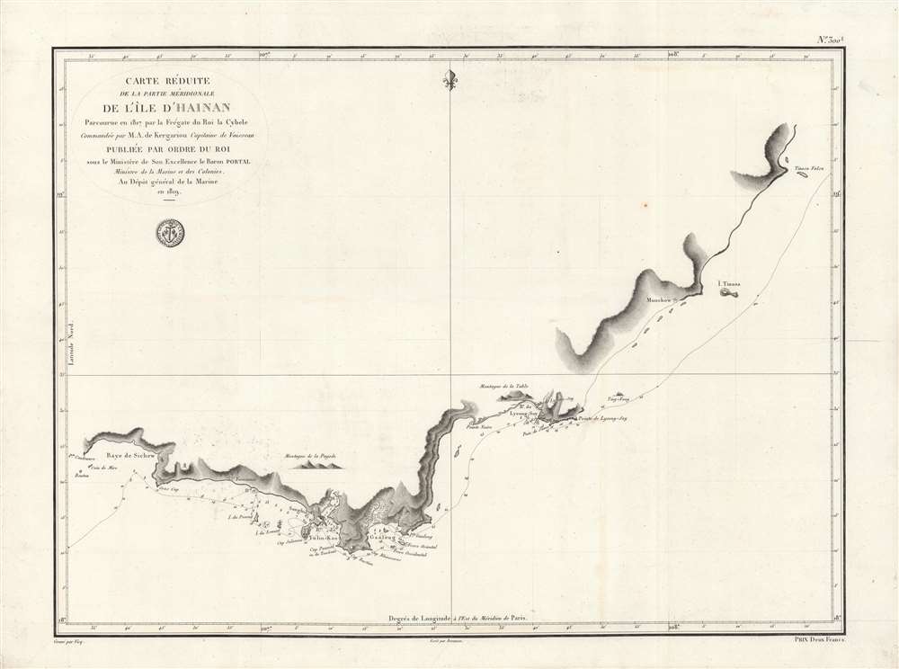
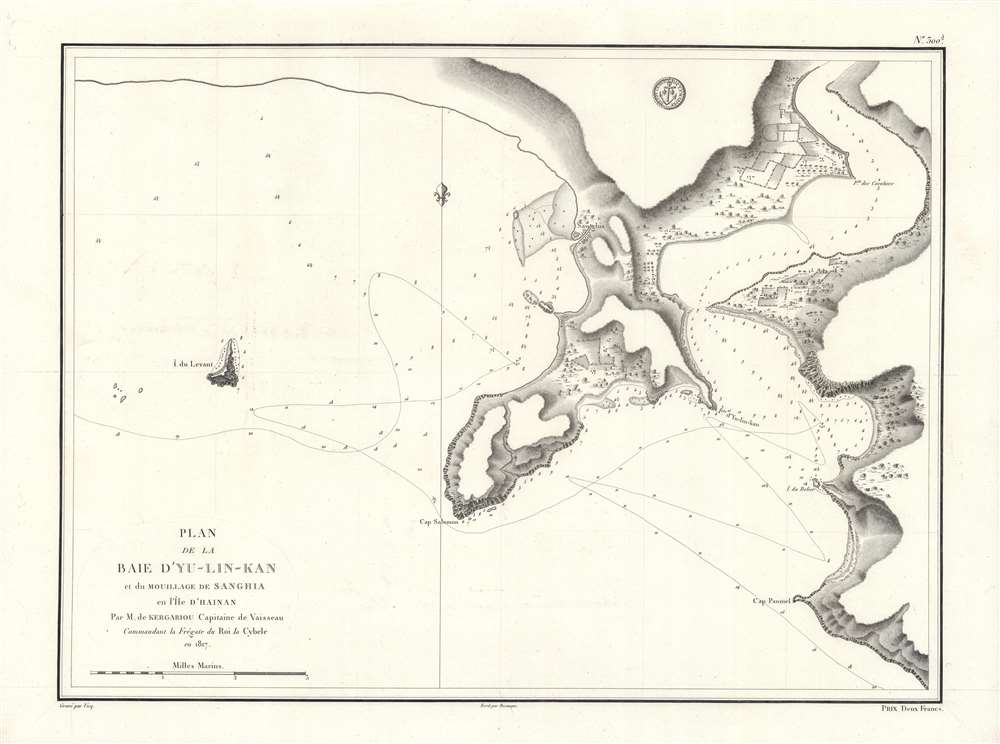
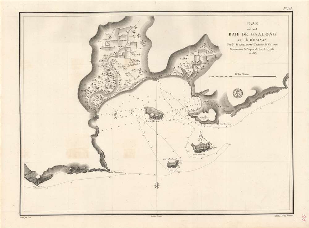
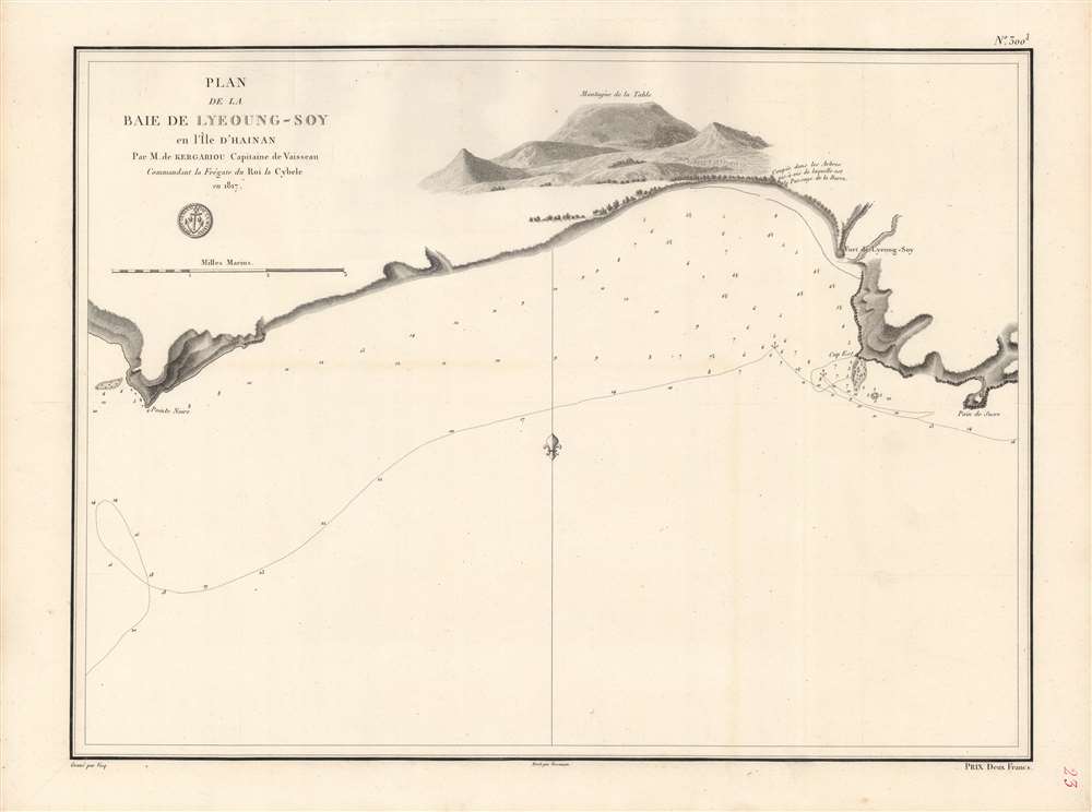
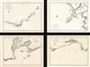
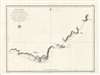
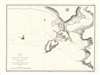
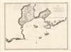
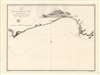
Soundings, hazards, sandbars, islands, and anchorages are indicated throughout the charts, as are landward features like villages, mountains, farms, forts, and rivers. In order of the images above, the charts are:
But Hainan's strategic location, jutting out into the South China Sea and forming the eastern side of the gulf of Tonkin, granted it a significance to maritime trade with points further south and west. The regular passage of trading vessels moving between Southeast Asia and southeastern China (especially Guangzhou), combined with often onerous tariffs, provided ample opportunities for piracy along the south China coast. Pirates flourished in the coastal inlets of Hainan, including those shown here, until the mid-19th century, when the British Navy aided the Qing in eradicating pirate havens.
At the time this map was made, the 'Canton system of trade' was at its peak. Britain was the major foreign player in this system, both the licit trade that operated through sanctioned Chinese traders (hongs) as well as the parallel illicit smuggling meant to skirt the restrictions of the sanctioned trading system. France was an important, if secondary, player in this system, but the French Revolution and the consequent wars meant that France was effectively inactive in the system for much of the 1790s-1810s. With the fall of Napoleon and Bourbon Restoration, France sought to reestablish its role in the Canton system, though now through private traders instead of the East India Company that had managed the 'China trade' in earlier years.
Late in the 19th century, France considered leasing a concession at Haikou or other ports in northern Hainan, but instead settled on Guangzhouwan on the Leizhou Peninsula, north of Hainan on the Chinese mainland.
A Closer Look
These charts trace the course of the French frigate Cybèle on a journey two years prior (1817) commanded by M. A. de Kargariou (not to be confused with other ships of the same name, including one that saw service in the French Revolutionary and Napoleonic Wars). The area covered includes the southernmost tip of Hainan Island, and by extension the southernmost point in China aside from historically uninhabited islands in the South China Sea.Today, these coasts and waters are part of Sanya Municipality, named for a small village noted here as Sanghia. At the time these charts were made, the local administrative unit was known as Yazhou. Yulin Bay is now a base for the Chinese Navy's nuclear submarine fleet, while Sanya is a popular tourist destination known for its beaches.
Soundings, hazards, sandbars, islands, and anchorages are indicated throughout the charts, as are landward features like villages, mountains, farms, forts, and rivers. In order of the images above, the charts are:
- Chart 1 (marked No. 300, 2 in the top-right corner), an overview of the southernmost points in Hainan (the coasts of today's Sanya Municipality).
- Chart 2 (No. 300, 5), focusing on Yulin Bay
- Chart 3 (No. 300, 4), centered on Gaalong (Yalong) Bay
- Chart 4 (No. 300, 3), a closer view of the 'Baie de Lyeong-soy' (Lingshui).
Historical Context
Hainan was historically a place of exile, where officials and intellectuals who fell out of favor with the court, including the renowned poet Su Shi (Su Dongpo), were banished to repent for their disobedience. As a mountainous, tropical island, battered by typhoons and largely inhabited by non-Chinese peoples (the Hlai or Li), most Chinese rulers were happy to keep the island at an arm's distance. < br>But Hainan's strategic location, jutting out into the South China Sea and forming the eastern side of the gulf of Tonkin, granted it a significance to maritime trade with points further south and west. The regular passage of trading vessels moving between Southeast Asia and southeastern China (especially Guangzhou), combined with often onerous tariffs, provided ample opportunities for piracy along the south China coast. Pirates flourished in the coastal inlets of Hainan, including those shown here, until the mid-19th century, when the British Navy aided the Qing in eradicating pirate havens.
At the time this map was made, the 'Canton system of trade' was at its peak. Britain was the major foreign player in this system, both the licit trade that operated through sanctioned Chinese traders (hongs) as well as the parallel illicit smuggling meant to skirt the restrictions of the sanctioned trading system. France was an important, if secondary, player in this system, but the French Revolution and the consequent wars meant that France was effectively inactive in the system for much of the 1790s-1810s. With the fall of Napoleon and Bourbon Restoration, France sought to reestablish its role in the Canton system, though now through private traders instead of the East India Company that had managed the 'China trade' in earlier years.
Late in the 19th century, France considered leasing a concession at Haikou or other ports in northern Hainan, but instead settled on Guangzhouwan on the Leizhou Peninsula, north of Hainan on the Chinese mainland.
Publication History and Census
These charts were produced by the Dépôt générale de la Marine in 1819. Each chart was engraved by 'Vicq.' and were lettered by J. P. Besançon. The only other known examples of these charts are held by the Centre de Documentation de l'École Militaire in Paris.CartographerS
Dépôt des Cartes et Plans de la Marine (fl. 1720 - present), often called the Dépôt de Marine, was a French hydrographic mapping organization founded in 1720 under Charles-Hercule of Albert de Luynes (1674 - 1734). Much like the U.S. Coast Survey, the British Admiralty, and the Spanish Deposito Hydrografico, the Dépôt was initiated as a storehouse and distribution center of existing nautical and marine charts. Eventually the Dépôt initiated its own mapping activities in an attempt to improve and expand upon existing material. Some of the more prominent cartographers and hydrographers associated with the of Dépôt des Cartes were, Philippe Buache, Jacques-Nicholas Bellin, Giovanni Rizzi-Zannoni, Rigobert Bonne, and Jean Nicolas Buache. More by this mapmaker...
J.P. Besançon (fl. c. 1798 - 1835) was a French engraver who specialized in lettering. Besançon began engraving nautical charts for Charles-François Beautemps-Beaupré (August 6, 1766 - March 16, 1854) in 1802. He engraved eighty-three maps for Beautemps-Beaupré, then the hydrographer in chief, between 1802 and 1831, when he handed off the work to J.M. Hacq. Little else is known about Besançon's life and career. Learn More...
Condition
Very good. Some discoloration along fold lines of first and fourth chart. Third chart has two spots of discoloration in the bottom-left quadrant. Some offsetting on the first and second chart.
References
OCLC 557640571.