This item has been sold, but you can get on the Waitlist to be notified if another example becomes available, or purchase a digital scan.
1917 U.S. Hydrographic Office Nautical Chart of the Lesser Antilles
HaitiSaintLucia-hydrographicoffice-1917$325.00

Title
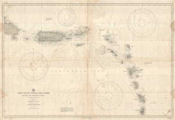
The West India Islands Haiti to Saint Lucia.
1917 (dated) 32.25 x 47.25 in (81.915 x 120.015 cm) 1 : 934000
1917 (dated) 32.25 x 47.25 in (81.915 x 120.015 cm) 1 : 934000
Description
This is a 1917 U.S. Hydrographic Office nautical chart or maritime map of the Lesser Antilles. The map depicts the region from the extreme eastern part of the Dominican Republic to Saint Lucia and includes Puerto Rico, the Virgin Islands, Montserrat, Antigua and Barbuda, St. Kitts and Nevis, Guadeloupe, Dominica, and Martinique. Myriad depth soundings are noted throughout, though they are concentrated in coastal waters near the islands, in passages between the islands, and the most-traveled shipping lanes. Locations along the coastline of each of the islands are labeled, as are cities, towns, and mountains. A railroad is illustrated along two-thirds of Puerto Rico's coastline as well. Notes concerning tides, currents, and other navigational topics are also noted, as is information concerning notations indicating lights, buoys, and the composition of seabeds.
This map was compiled and published by the U.S. Hydrographic Office in 1917.
This map was compiled and published by the U.S. Hydrographic Office in 1917.
Cartographer
United States Hydrographic Office (1866 - 1962) was a brach of he U.S. Navy that prepared and published maps, charts, and nautical books to aid in navigation. Before the establishment of the Hydrographic Office in 1866, U.S. navigators were almost entirely dependent on British charts. There had been a few private enterprises that had prepared and published charts, but none had been able to do so profitably. The Office was established 'for the improvement of the means of navigating safely the vessels of the Navy and of the mercantile marine, by providing, under the authority of the Secretary of the Navy, accurate and cheap nautical charts, sailing directions, navigators, and manuals of instructions for the use of all vessels of the United States, and for the benefit and use of navigators generally.' This way the Navy Department could furnish navy and merchant ships with charts illustrating the results of surveys and explorations undertaken by naval officers. The charts were priced to cover the cost of paper and printing alone, not preparation. Its main objective was to survey foreign coasts, as the Coast and Geodetic Surveys were responsible for surveying domestic waters. The Hydrographic Office was transferred from the Department of the Navy to the Department of Defense in 1949 and was replaced by the Naval Oceanographic Office in 1962. More by this mapmaker...
Condition
Good. Even overall toning. Blank on verso.