This item has been sold, but you can get on the Waitlist to be notified if another example becomes available, or purchase a digital scan.
1757 Homann Heirs Map of Halifax, Quebec City, and Louisbourg, Canada
HalifaxQuebecLouisbourg-homannheirs-1757$375.00

Title
Vorstellung einiger Gegenden und Plaetze in Nord-America unter Franzoesisch und Englische Jurisdiction gehoerig.
1757 (undated) 19 x 21 in (48.26 x 53.34 cm)
1757 (undated) 19 x 21 in (48.26 x 53.34 cm)
Description
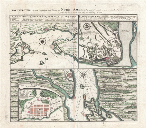
An attractive 1756 Homann Heirs map of the Canadian cities of Halifax (Nova Scotia), Louisbourg (Nova Scotia) and Quebec City (Quebec) at the outset of the French and Indian War (1756 – 1763). Essentially four maps on one sheet. Homann no doubt issued this map with the intention to take advantage of continental interested in the events of the French and Indian war or, as it was known in Europe, the Seven Years War.
The primary map, occupying the lower two quadrants, illustrates Halifax town and harbor just seven years after being founded by the English in 1749. The map details the entrance to Halifax Harbor, the town, and some of the surrounding countryside. A large inset map, in the lower left quadrant, illustrated the town of Halifax in greater detail with special attention to its defenses and fortifications. These maps feature English text suggesting that Homann Heirs derived the content form English sources.
This is a sharp contract to the to upper maps, of Louisbourg and Quebec, which at this time were still in French control and exhibit French text. The Louisbourg map, occupying the upper left quadrant covers the port, its entrance, and some of the surrounding territory. Louisbourg was the primary French fortress in the region and an essential conquest for control of the Gulf of Saint Lawrence. One year after this map was made, in 1858, the British seized Louisbourg and raised its defenses.
The Quebec map, appearing in the upper right quadrant, is heavily focused on the city of Quebec and features considerable detail. The city's impressive fortifications as well as the surrounding farm land are clearly depicted. The block structure of the Basse Ville, or Lower Town is also well illustrated. Quebec was the capital of French North America. It was strategically situated, as this map suggests, on a promontory overlooking the Saint Lawrence River. Considered by many to be impregnable, the British General James Wolfe outsmarted the French commander, the Marquis de Montcalm, to battle on the open field, where he was defeated. The British took control of the city and sealed the fate of French America.
Cartographer
Homann Heirs (1730 - 1848) were a map publishing house based in Nuremberg, Germany, in the middle to late 18th century. After the great mapmaker Johann Baptist Homann's (1664 - 1724) death, management of the firm passed to his son Johann Christoph Homann (1703 - 1730). J. C. Homann, perhaps realizing that he would not long survive his father, stipulated in his will that the company would be inherited by his two head managers, Johann Georg Ebersberger (1695 - 1760) and Johann Michael Franz (1700 - 1761), and that it would publish only under the name 'Homann Heirs'. This designation, in various forms (Homannsche Heirs, Heritiers de Homann, Lat Homannianos Herod, Homannschen Erben, etc..) appears on maps from about 1731 onwards. The firm continued to publish maps in ever diminishing quantities until the death of its last owner, Christoph Franz Fembo (1781 - 1848). More by this mapmaker...
Condition
Very good. Minor verso reinforcement along centerfold.
References
Boston Public Library, Leventhal Collection, G3404.A1 1756 .H66. Sellers, John R. and Van Ee, Patricia, Maps and Charts of North America, #275. Kershaw, K. A., Early Printed Maps of Canada, #1051. Tooley (Amer) p.214, #134.