This item has been sold, but you can get on the Waitlist to be notified if another example becomes available, or purchase a digital scan.
1871 Belloguet Allegorical Caricature Map of France
HallucinationTopographique-belloguet-1871$1,250.00

Title
Hallucination topographique sur la carte de France.
1871 (dated) 19.25 x 24.25 in (48.895 x 61.595 cm)
1871 (dated) 19.25 x 24.25 in (48.895 x 61.595 cm)
Description
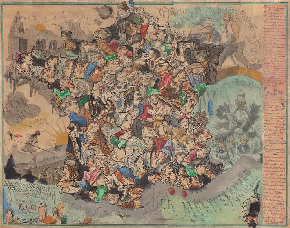
Published in July 1871, this is satirist André Belloguet's extremely rare caricature map of France. The map emerged at one of the most fraught periods in French history - following closely on the French defeat in the Franco-Prussian War (1870 - 1871), the consequent loss of Alsace and Lorraine, and the chaos of the Paris Commune (1871).
Interpreting the Map
Here, Belloguet illustrates each of France's departments (départements) as a caricature, nearly all sporting a regional hairstyle or hat and exaggerated features. Belloguet fills the 'voids' around France with meaningful vignettes referencing the turmoil of the previous year. Peace and Liberty (Paix et Liberté) occupy the upper left (in the English Channel) as a banner above a destroyed village, graves, and shadowy soldiers. Below, in the Bay of Biscay, the Latin phrase 'Alea Iacta Est' ('the die is cast') floats above Marianne (the French national symbol) as she tightrope walks toward the rising sun of 1872. Huge flying bugs perch on either end of her balancing pole and wave red and white flags, likely a reference to the bloody Siege of Paris. To the east, in continental Europe, a knight covers his eyes in shame, a reference to France's military defeat. Below, Kaiser Wilhelm sits atop a throne being pulled forward toward France with Kaupt, the arms manufacturer, blazing the way. Explanatory text entitled 'Petarade Historique' (Historical Backfire) appears to the right of the map.The Franco-Prussian War
The Franco-Prussian War lasted from July 19, 1870 until January 28, 1871. The French suffered a series of defeats that eventually led to a siege of Paris, which lasted from September 17, 1870, until January 28, 1871. Over 180,000 Prussian and German soldiers laid siege to the city, and even though a reported 500,000 French soldiers occupied Paris, the Prussian army outclassed the French to such a degree that the French army could not break the siege. The Prussian commanders had no intention of attacking the city. However, as the siege wore on, it became obvious that such measures would be necessary. In the end, over 12,000 shells were fired on Paris in an effort to break Parisian morale. Paris also suffered horrible outbreaks of tuberculosis and other diseases during the siege. The Armistice was finally signed on January 27th, and the siege lifted. The Germans held a victory parade in Paris on March 1, 1871.The Paris Commune
The Paris Commune governed Paris from March 18, 1871 until May 28, 1871. It was a radical socialist, anti-religious, and revolutionary government that emerged from the chaos of the Siege of Paris during the Franco-Prussian War. After controlling Paris for two months, the regular French Army suppressed the uprising in what has become known as 'The Bloody Week' (La semaine sanglante). 6,667 Parisians were confirmed to have been killed during that week, but unconfirmed estimates place the death toll somewhere between 10,000 and 20,000.Publication History and Census
This map was created and produced by André Belloguet in July 1871. We note two cataloged examples one at the Bibliothèque nationale de France and the other in the Archives of the Département des Hauts-de-Seine.Cartographer
André Belloguet (1830 - 1873, c. 188x) was a French artist, caricaturist, and lithographer. Belloguet created numerous political cartoons and satirical maps of France and Europe over the course of his career and collaborated with numerous French magazines. Many featured caricatures with incredible expressions, facial structures, and distinctive hats. Belloguet created a large corpus of work during the Franco-Prussian War, the siege of Paris, and the Paris Commune (1870 - 1871) and examples of some of these works can be found in the poster collection of the Département des Hauts-de-Seine in France. A list of forty works published during this era is included in Maurice Quentin-Bauchart's La caricature politique en France pendant la guerre, le siège de Paris et la Commune published in 1890. Most references for Belloguet cite his death date as 1873. However, Roderick Barron's 2008 article Bringing the map to life: European satirical maps 1845 - 1945 states that Belloguet fled Paris after the Paris Commune in 1871 and settled in Brussels, where he worked for the magazine Le Lutin. Also according to Barron Belloguet published at least one satirical map in Brussels that used animals as personifications for European nations entitled L'Europe Animale, Physiologie Comique in 1882. More by this mapmaker...
Condition
Good. Backed on archival tissue for stability. Areas of infill in text along right. Repaired tears evident. Other small areas of infill apparent.
References
Affiches anciennes conservées par le département des Hauts-de-Seine 23FI593. OCLC 456931961.