This item has been sold, but you can get on the Waitlist to be notified if another example becomes available.
1860 Walling Wall Map of Mount Desert Island, Hancock Co., Maine (Acadia)
HancockMaine2-walling-1860$1,875.00

Title
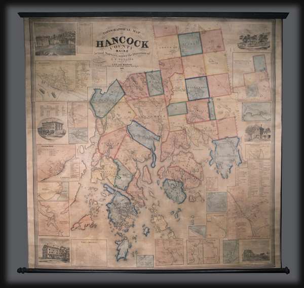
Topographical Map of Hancock County Maine.
1860 (dated) 60 x 61 in (152.4 x 154.94 cm) 1 : 70000
1860 (dated) 60 x 61 in (152.4 x 154.94 cm) 1 : 70000
Description
This is an 1860 Henry Francis Walling wall map of Hancock County, Maine. The map depicts from Aurora and Amherst to Isle au Haut and from the Penobscot River to Gouldsborough. Divided into townships, several towns in Hancock County are labeled, including Penobscot, Bucksport, Brooklin, Franklin, Ellsworth, and Surry. Mount Desert Island, the site of Acadia National Park, is also included in excellent detail. Along the roads, the names of individual inhabitants are listed. Inset maps of Bucksport (complete with vignettes of boats on the Penobscot River), Orland, Surry, Castine, Sedgewick, Brooklin, Deer Isle, The Colony, Blue Hill, Tremont, Southwest Harbor, Mount Desert or Somesville, Ellsworth, Gouldsborough, Penobscot, Falls Village, Winter Harbor, and Sullivan encircle the map. An inset of the northern portion of Hancock County is situated in the upper right corner, completing the depiction of all 40 townships. Views of several buildings are included around the central map was well: the court house in Ellsworth, Bradey and Co. in Bucksport, Freeman House in Sothwest Harbor, the Robinison House, Bradley's Block and the East Maine Conference Seminary in Bucksport. Directories are listed alongside several the inset maps. A table of the census of towns in Hancock County is included in ton the upper left, as well as a table of distances on the bottom left.
This map was produced by Henry Francis Walling and published by Lee and Marsh of New York in 1860.
This map was produced by Henry Francis Walling and published by Lee and Marsh of New York in 1860.
Cartographer
Henry Francis Walling (June 11, 1825 - April 8, 1889) was an American civil engineer, cartographer, surveyor, and map publisher active from the middle to late 19th century. Walling was born in Providence, Rhode Island. He studied/worked at the Providence Athenaeum before discovering a talent for mathematics and surveying. Walling took a position with Samuel Barrett Cushing (1846 - 1888), a Providence-based civil engineer with whom he issued in 1846 a revision of James Steven's Topographical Map of the State of Rhode-Island. Walling established himself independently around 1850 and immediately began preparing a series of town plans focusing on Bristol County, near Providence. Buoyed by widespread interest in his plans, Walling expanded his operations to Massachusetts, where, by 1857, he had produced no less than 50 town plans. Apparently, Walling's business model involved a contract with town officials to produce a certain number of maps, after which he acquired the right to print and sell additional copies on his own account. This work eventually led to Walling's appointment as Massachusetts "Superintendent of the State Map", a designation that began appearing on his maps around 1855. While Walling's work focused heavily on city and county maps, he successfully published three scarce state maps: Maine, Vermont, and Rhode Island. In 1856, Walling relocated his headquarters to New York City, where he had better access to quality lithographers. The Civil War (1861 - 1865) proved difficult for Walling, and diminished sales may have forced him into a partnership with Ormando W. Gray, with whom he published numerous state, county, and national atlases in the 1860s and 1870s. Around 1880, Walling took a post with the U.S. Coast Survey, with whom he worked on various charts until requesting a transfer in 1883 to the newly formed U.S. Geological Survey. Walling remained with the Geological Survey until his untimely death of a heart attack in April 1889. More by this mapmaker...
Condition
Very good. Full professional restoration. Backed on linen. Attached to rollers which add four inches to the height and five inches to the width.
References
OCLC 192004218.