This item has been sold, but you can get on the Waitlist to be notified if another example becomes available.
1922 Sanborn Map Company Insurance Atlas of Hartford, Connecticut
HartfordAtlas-sanborn-1922$475.00

Title
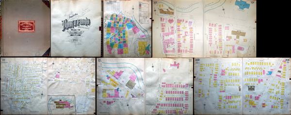
Insurance Maps of Hartford, Connecticut Volume II.
1922 (dated) 26.5 x 24.5 in (67.31 x 62.23 cm)
1922 (dated) 26.5 x 24.5 in (67.31 x 62.23 cm)
Description
This is a scarce 1922 atlas containing insurance maps of Hartford, Connecticut, published by the Sanborn Map Company in New York. The atlas contains seventy seven hand colored maps covering parts of Hartford. Maps identify streets, individual buildings, rivers, and other important topographic features. The maps are color coded to indicate fire proof construction, hollow concrete or cement block construction, brick buildings, frame buildings etc., with a key on the first page, noting other construction information useful for insurance purposes. The first page also contains a correction record indicating corrections made in March 1930 and March 1931. Some maps also contain paper overlays in some parts, indicating corrections or additions. An index is including in the first couple of pages. Overall, this is a remarkable collection of maps and among the most detailed mapping of Hartford to appear until the modern era of GPS. This atlas was published and copyrighted by the Sanborn Map Company, New York in 1922 and issued as Insurance Maps of Hartford, Connecticut, Volume II.
Source
Sanford Map Company, Hartford, Conn. Volume 2 (New York), 1922.
Condition
Very good. Minor wear and some warping of pages along edges. Cover exhibits minor stains.