This item has been sold, but you can get on the Waitlist to be notified if another example becomes available, or purchase a digital scan.
1749 Kitchin map of Hertfordshire
Hartfordshire-kitchin-1749$125.00

Title
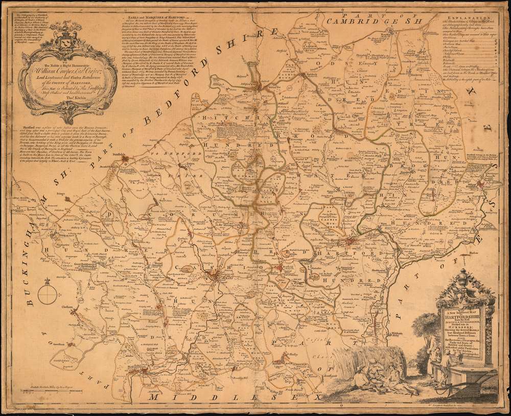
A New Improved Map of Hartfordshire from the Best Surveys.
1749 (undated) 20.75 x 25.75 in (52.705 x 65.405 cm) 1 : 100000
1749 (undated) 20.75 x 25.75 in (52.705 x 65.405 cm) 1 : 100000
Description
A beautifully engraved 1749 Kitchin map of Hertfordshire, with a humorous decorative cartouche celebrating the region’s famed production of barley, malt, and beer. The map, based on the 1724 Payler Smith map of Middlesex, Hertfordshire and Essex, offers granular detail. Vicarages and Rectories, charity schools and religious houses are shown; post stages, parks, mills, and roads of varying quality are all identified. Beyond showing physical features, the map also notes the market days for each town, and notes the distances between market towns. Towns are also annotated to indicate their attachment to various noble titles, and to indicate particularly important trade goods. For example, the note for Hitchen explains:
it was formerly a place of great note for the Woolen Manufacture, but now that Trade is quite lost. However their Market for Grain, especially Malt is still much frequented.The cartouche alludes to the Gin Craze - an epidemic of unchecked gin consumption afflicting Great Britain in the first half of the 18th century. It depicts a man and woman bellying up to a bar with a devil-headed spigot pouring gin into the man's outstretched hat. This is intended to be in sharp contrast to the adjoining picnic-scene of men and women, reclining on the ground next to a barley field, with a loaf of bread and a rack of ribs, guzzling beer directly from a keg. The gin-drinkers are dressed in slatternly tatters, while the beer-drinkers are neatly clothed and rosy-cheeked. Beer, after all, was considered to be the healthy alternative to the cheap gin flooding the London market, which was not infrequently flavored with turpentine.
Publication History and Census
Though engraved in 1749, Kitchen’s map did not receive publication until the completion of The Large English Atlas, published jointly with Emanuel Bowen in 1760. This work was the first large scale atlas of English counties since the atlases of Blaeu and Jansson a century earlier. The Atlas was reissued by various publishers, the maps unchanged, until c.1794.CartographerS
Thomas Kitchin (August 4, 1718 – June 23, 1784) was a London based engraver, cartographer, and publisher. He was born in London to a hat-dyer of the same name. At 14, Kitchin apprenticed under Emanuel Bowen, under whom he mastered the art of engraving. He married Bowen daughter, Sarah Bowen, and later inherited much of his preceptor's prosperous business. Their son, Thomas Bowen Kitchin, also an engraver joined the family business, which thereafter published in Thomas Kitchin and Son. From 1858 or so Kitchin was the engraver to the Duke of York, and from about 1773 acquired the title, 'Royal Hydrographer to King George III.' He is responsible for numerous maps published in the The Star, Gentleman's Magazine, and London Magazine, as well as partnering with, at various times, with Thomas Jefferys, Emmanuel Bowen, Thomas Hinton, Issac Tayor, Andrew Dury, John Rocque, Louis de la Rochette, and Alexander Hogg, among others. Kitchin passed his business on to his son, Thomas Bowen Kitchin, who continued to republish many of his maps well after his death. Kitchin's apprentices included George Rollos, Bryant Lodge, Thomas Bowen Kitchin, Samuel Turner Sparrow, John Page, and Francis Vivares. More by this mapmaker...
Emanuel Bowen (1694 - May 8, 1767) had the high distinction to be named Royal Mapmaker to both to King George II of England and Louis XV of France. Bowen was born in Talley, Carmarthen, Wales, to a distinguished but not noble family. He apprenticed to Charles Price, Merchant Taylor, from 1709. He was admitted to the Merchant Taylors Livery Company on October 3, 1716, but had been active in London from about 1714. A early as 1726 he was noted as one of the leading London engravers. Bowen is highly regarded for producing some of the largest, most detailed, most accurate and most attractive maps of his era. He is known to have worked with most British cartographic figures of the period including Herman Moll and John Owen. Among his multiple apprentices, the most notable were Thomas Kitchin, Thomas Jeffreys, and John Lodge. Another apprentice, John Oakman (1748 - 1793) who had an affair with and eventually married, Bowen's daughter. Other Bowen apprentices include Thomas Buss, John Pryer, Samuel Lyne, his son Thomas Bowen, and William Fowler. Despite achieving peer respect, renown, and royal patronage, Bowen, like many cartographers, died in poverty. Upon Emanuel Bowen's death, his cartographic work was taken over by his son, Thomas Bowen (1733 - 1790) who also died in poverty. Learn More...
Anthony Walker (March 19, 1726 - May 9, 1765) was a London draughtsman, etcher and engraver. He designed and executed decorative cartouches and title pages for the map trade. His work appeared in the Kitchin and Jefferys Small English Atlas, the Kitchin and Bowles Large English Atlas, and many separately issued maps, views, illustrations and trade-cards. Learn More...
Source
Bowen, E. The Large English Atlas. (London: Bowles) 1763 and later editions.
Condition
Good. Evenly toned. Trimmed and mounted on old linen. Manuscript reinstatement of border at lower right corner.
References
OCLC 43184049. Hodson Printed Maps of Hertfordshire ref. 36(v)