This item has been sold, but you can get on the Waitlist to be notified if another example becomes available, or purchase a digital scan.
1850 U. S. Coast Survey Map of Cape Hatteras and Surrounding Shoals, North Carolina
HatterasShoals-uscs-1850$100.00

Title
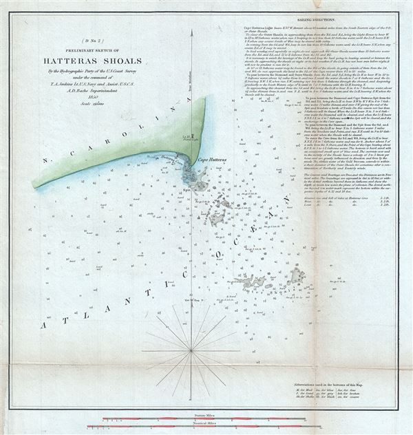
(D No. 2) Preliminary Sketch of Hatteras Shoals.
1850 (dated) 12 x 11.5 in (30.48 x 29.21 cm) 1 : 120000
1850 (dated) 12 x 11.5 in (30.48 x 29.21 cm) 1 : 120000
Description
This is a fine example of the 1850 U. S. Coast Survey's nautical chart of Cape Hatteras on the Hatteras Island in North Carolina, and its surrounding shoals. It covers Cape Hatteras and Hatteras Cove and includes Diamond Shoal and the Outer Shoals.
Cape Hatteras is the furthest point to the east on the Hatteras Island and is also close to the meeting point of the two major Atlantic currents; the cold Labrador Current from the north and the warmer Gulf Stream from the south, causing rough seas and making navigation for ships difficult. This chart includes detailed sailing directions as well as numerous soundings to help navigate these rough waters. Because of the numerous ships that have been lost here, sailing close to the shoals and trying to navigate around the shifting sandbars, the area is also known as the 'Graveyard of the Atlantic.'
The old lighthouse, built in 1803 is noted on this chart. Prepared by T. A. Jenkins under the supervision of A. D. Bache, one of the most influential and prolific Superintendents of the Coast Survey, and issued in the 1850 edition of the Superintendent's Report.
Cartographer
The Office of the Coast Survey (1807 - present) founded in 1807 by President Thomas Jefferson and Secretary of Commerce Albert Gallatin, is the oldest scientific organization in the U.S. Federal Government. Jefferson created the "Survey of the Coast," as it was then called, in response to a need for accurate navigational charts of the new nation's coasts and harbors. The spirit of the Coast Survey was defined by its first two superintendents. The first superintendent of the Coast Survey was Swiss immigrant and West Point mathematics professor Ferdinand Hassler. Under the direction of Hassler, from 1816 to 1843, the ideological and scientific foundations for the Coast Survey were established. These included using the most advanced techniques and most sophisticated equipment as well as an unstinting attention to detail. Hassler devised a labor intensive triangulation system whereby the entire coast was divided into a series of enormous triangles. These were in turn subdivided into smaller triangulation units that were then individually surveyed. Employing this exacting technique on such a massive scale had never before been attempted. Consequently, Hassler and the Coast Survey under him developed a reputation for uncompromising dedication to the principles of accuracy and excellence. Unfortunately, despite being a masterful surveyor, Hassler was abrasive and politically unpopular, twice losing congressional funding for the Coast Survey. Nonetheless, Hassler led the Coast Survey until his death in 1843, at which time Alexander Dallas Bache, a great-grandson of Benjamin Franklin, took the helm. Bache was fully dedicated to the principles established by Hassler, but proved more politically astute and successfully lobbied Congress to liberally fund the endeavor. Under the leadership of A. D. Bache, the Coast Survey completed its most important work. Moreover, during his long tenure with the Coast Survey, from 1843 to 1865, Bache was a steadfast advocate of American science and navigation and in fact founded the American Academy of Sciences. Bache was succeeded by Benjamin Pierce who ran the Survey from 1867 to 1874. Pierce was in turn succeeded by Carlile Pollock Patterson who was Superintendent from 1874 to 1881. In 1878, under Patterson's superintendence, the U.S. Coast Survey was reorganized as the U.S. Coast and Geodetic Survey (C & GS) to accommodate topographic as well as nautical surveys. Today the Coast Survey is part of the National Oceanic and Atmospheric Administration or NOAA as the National Geodetic Survey. More by this mapmaker...
Source
Bache, A. D., Report of the Superintendent of the United States Coast Survey, (Washington) 1850.
Condition
Very good. Some wear and toning on original fold lines. Backed on archival tissue for stability. Minor spotting.