This item has been sold, but you can get on the Waitlist to be notified if another example becomes available, or purchase a digital scan.
1915 Berthrong Map of Hawaii
Hawaii-berthrong-1915$425.00

Title
Map of the Territory of Hawaii.
1915 (dated) 23.5 x 34 in (59.69 x 86.36 cm) 1 : 760320
1915 (dated) 23.5 x 34 in (59.69 x 86.36 cm) 1 : 760320
Description
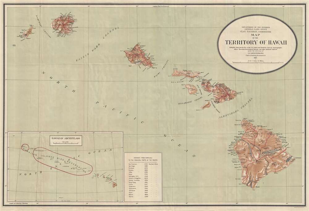
This is a 1915 I. P. Berthrong map of Hawaii. The map depicts eight of the Hawaiian Islands: Hawaii, Maui, Kahoolawe, Lanai, Molokai, Oahu, Kauai, and Nihau. Hawaii, Maui, Oahu, and Kauai are divided into regions. On the island of Hawaii, both Kilauea and Mauna Loa are labeled, as well as the Crater of Moku'āweoweo, the summit caldera of Mauna Loa. Several lava flows are illustrated. Rivers and towns are depicted on all the islands, as well as bays and harbors along their coasts. An inset map of the Hawaiian Archipelago is situated at the bottom left. This inset labels the Hawaiian Islands Bird Reservation, which includes all the smaller islands in the archipelago except for Midway Island. A table with distances to the 'principal ports of the Pacific' is placed next to the inset, and includes distances to San Francisco, San Diego, Nome, Wellington, Sydney, Hong Kong, Yokohama, and Manila, among others.
Publication History
This map was produced under the direction of I. P. Berthrong for the Annual Reports of the Department of the Interior in 1915.Cartographer
The General Land Office (GLO) (1812 - 1946) was an independent agency of the United States government responsible for public domain lands in the United States. Created in 1812, it took over functions previously conducted by the Department of the Treasury. The GLO oversaw the surveying, platting, and sale of public lands in the western United States. It also administered the Preemption Act of 1841, which allowed individuals who were already living on federal land to purchase up to 160 acres of land before it was offered for sale to the general public, if they met certain requirements. Following the passage of the Homestead Act in 1862, which was also administered by the GLO, claims under the Preemption Act sharply decreased. The GLO became a part of the newly-created Department of the Interior in 1849. In 1891 Grover Cleveland and Congress created 17 forest reserves, due to public concern over forest conservation, which were initially managed by the GLO, until they were transferred to the Forest Service in 1905. In 1946 the Government Land Office was merged with the United States Grazing Service to become the Bureau of Land Management. Today the Bureau of Land Management administers the roughly 246 million acres of public land remaining under federal ownership. More by this mapmaker...
Source
Department of the Interior, Reports of the Department of the Interior for the Fiscal Year Ended June 30 1915, (Washington: Government Printing Office) 1916.
Condition
Very good. Slight wear along original fold lines. Blank on verso.
References
OCLC 173373404.