This item has been sold, but you can get on the Waitlist to be notified if another example becomes available, or purchase a digital scan.
1797 Perouse Map of Hawaii
Hawaii-perouse-1797$500.00

Title
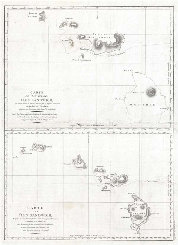
Carte des parties des Iles Sandwich, qui ont ete visitees aus mois de Mai 1786 par les Fregates Francaises la Boussole et l'Astrolabe / Carte des Iles Sandwich, assujettie aux observations faites a bord des Fregates Francaises la Boussole et l'Astrolabe.
1797 (undated) 28 x 20 in (71.12 x 50.8 cm) 1 : 760000
1797 (undated) 28 x 20 in (71.12 x 50.8 cm) 1 : 760000
Description
A fine example of Jean François de Galaup, comte de La Pérouse and Gérard Sébastien Bernizet's map of Hawaii or the Sandwich Islands. Essentially two maps on a single sheet. The uppermost map details La Pérouse and Bernizet's shipboard surveys of the islands of Hawaii (Owhyhee), Maui (Mowée), Molokai (Morotoi), Oahu (Woahoo) and Niihau (Oneeheow). The mapping shows partial shorelines on all islands, suggesting incomplete survey work. Nonetheless, Pérouse praises Bernizet and his astronomer, Joseph Lepaute Dagelet (1751-1788), for their fine work:
La Pérouse, Bernizet, Dagelet, and the rest of the crew died tragically on a shipwreck near the Solomon Islands. His journals were shipped back to Europe from Australia before the shipwreck and posthumously published in 1797, along with an accompanying atlas volume, from which this map was drawn, Atlas du voyage de La Perouse.
Messrs. Dagelet and Bernizet have taken with the greatest care all bearings of the part of Mowee along which we coasted, as well as those of Morokinne. It was impossible for the English, who never came nearer than ten leagues, to have given any exact information respecting these coasts. Br. Bernizet has drawn a very good plan, and Mr. Dagelet has joined astronomical observations, which deserve the same confidence as those of Cook, and which for the conveniency of the reader, are al inserted in tables at the end of the work. They show our course and precise situation from day to day, in latitude and longitude, by observation and by reckoning.The language of La Pérouse cannot hide the fact that the French are trying, through La Pérouse, to match or outdo the outstanding exploratory accomplishments of the English under Cook. The second map, nonetheless, synthesizes the work of Bernizet and Cook to produce the most accurate and advanced mapping of the Hawaiian Islands yet. Despite a more advanced mapping, one cannot fail to notice the fact that all of the islands are foreshortened on the east west axis. There is no clear explanation, especially since it is not a feature copied for earlier work. Gary Fitzpatrick, in his Early Mapping of Hawai'I speculates that it may have something to do with the distance the French believed they could see from their ship. La Pérouse and his crew assumed they could see about 35 – 42 miles where as they could actually only see about 13 -14 miles. Such an erroneous assumption must have wrought havoc with their shipboard calculations, especially when they attempted to reconcile them with the discoveries of Cook.
La Pérouse, Bernizet, Dagelet, and the rest of the crew died tragically on a shipwreck near the Solomon Islands. His journals were shipped back to Europe from Australia before the shipwreck and posthumously published in 1797, along with an accompanying atlas volume, from which this map was drawn, Atlas du voyage de La Perouse.
CartographerS
Jean François de Galaup, Comte de La Pérouse (August 23, 1741 - 1788) was a French naval officer, navigator, and explorer active in the later part of the 18th century. Born into a noble family of Albi, France, La Perouse entered the navel college of Brest at just 15. At seventeen La Perouse made his first naval voyage, a supply expedition to the fort of Louisbourg in New France. He later participated in a number of naval battles, mostly against the English, and eventually rose to the rank of Commodore. In 1782 he captured the English forts Prince of Wales and York, making a name for himself back in France. Following the British defeat at the end of the American Revolutionary War, La Perouse was appointed by Louis XVI to lead an expedition of discovery circumnavigating the globe. The goal of the expedition was to complete and correct the maps of the Pacific drawn by Captain Cook. La Perouse's two frigates, the Astrolabe and the Boussole rounded Cape Horn and entered the Pacific in 1785. Crisscrossing the Pacific from Macau and Japan to Alaska, Vancouver, and the Hawaiian Islands Perouse made numerous discoveries and adding considerably to the cartographic corpus, particularly along the coast of British Columbia and around Japan. In Australia La Perouse sent his last letter back to France containing all of his maps and research. Tragically, on the return voyage La Perouse ran into a violent storm which left both of his frigates shipwrecked on the Polynesian island of Vanikoro, part of the Santa Cruz Group. Some of the survivors of the shipwrecks seem to have managed to live on the island for years afterwards. As late as 1790 the English Captain Edward Edwards saw smoke signals coming from Vanikoro but foolishly declined to investigate. Expeditions in 2005 and in 2008 identified the remains of both ships and retuned numerous artifacts from the ill-fated expedition to France. The importance of La Perouse's discoveries was, unfortunately, not seriously appreciated until many years later because, when the La Perouse maps were finally published in 1797, newer more accurate maps of the region were already in circulation. Nonetheless, La Perouse remains of the titans of Pacific exploration and he work paved the path forward for all future expeditions to the region. More by this mapmaker...
Gérard Sébastien Bernizet (March 2, 1760 – May, 1788) was a French cartographer and geographical engineer. His best known for his work as chief cartographer on the La Perouse Expedition (1785 – 1789). Bernizet can be credited with many of the cartographic advances (and errors) associated with the expedition. The La Perouse expedition shipwrecked on the island of Vanikoro, part of the Santa Cruz group in the Solomon Islands. Although some of the sailors may have survived the initial shipwreck, none ever returned to Europe. The records of the La Perouse expedition survive because La Perouse prudently sent copies of his journals back to Europe onboard ad British Nave ship from the First Fleet (The Alexander) which he encountered en route. Learn More...
Source
La Perouse, Jean-Francois de Galaup, comte de, Atlas du voyage de La Perouse, (Paris) 1797.
Condition
Very good. Some fold wear and soiling - see image at center. Else clean.
References
Rumsey 3355.013. Fitzpatrick, G. L., The Early Mapping of Hawai'i, (London) pages 25 - 31. OCLC 48372225. Howes, W., U.S.iana (1650-1950): A Selective Bibliography in which are Described 11,620 Uncommon and Siginficant Books Relating to the Continental Portion of the United States, 93.