
This item below is out of stock, but another example (left) is available. To view the available item, click "Details."
Details
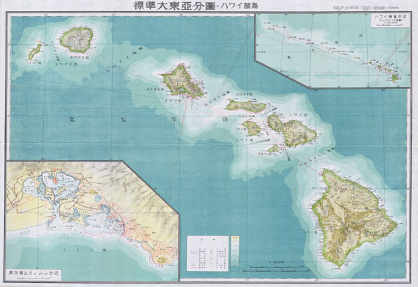
1943 Seitosha Japanese Co-prosperity Sphere Map of Hawaii
$475.00
1943 Japanese Coprosperity Sphere Map of Hawaii
Hawaii-wwii-1943$200.00

Title
Hawaii
1943 (dated) 20 x 29 in (50.8 x 73.66 cm)
1943 (dated) 20 x 29 in (50.8 x 73.66 cm)
Description
One of the most beautiful maps of Hawaii ever produced. A stunning large format Japanese map of Hawaiian Island group dating to World War II. Covers the entirety of the Hawaiian Islands with a large inset city plan of Honolulu in the lower left quadrant. Another inset in the upper right quadrant shows the Hawaiian Islands relative to other Pacific Islands in the greater vicinity. Offers superb detail regarding both topographical and political elements. Notes cities, roads, trade routes on air, sea and land, and uses shading to display oceanic depths. Scale of 1:85,000. All text in Japanese. This map was created as part of a series of folding maps of parts of Asia and the Pacific prepared by the Japanese during World War II. This map is no. 18 in that series.
Source
Independent Issue.
Condition
Very good condiiton. Original folds. Comes with original folder.