1905 Brooklyn Daily Eagle Map of Hawaii and Puerto Rico
HawaiiPR-brooklyndailyeagle-1905$100.00

Title
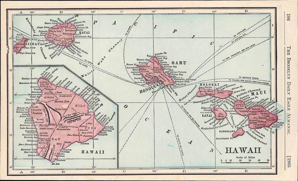
Hawaii.
1905 (dated) 5.25 x 8.75 in (13.335 x 22.225 cm) 1 : 2500000
1905 (dated) 5.25 x 8.75 in (13.335 x 22.225 cm) 1 : 2500000
Description
Maps of Hawaii and Puerto Rico, published in the 1905 edition of the Brooklyn Daily Eagle Almanac. The maps date to soon after the Spanish-American War, during which both territories were annexed by the United States.
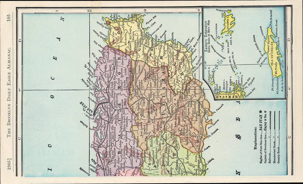
The verso (back) is a map of the eastern half of Puerto Rico, that was evidently paired with a map showing the other half of the island on the opposite page. An inset map shows the islands of Culebra, Vieques, and other small islands off the east coast of Puerto Rico. A legend is included showing the notation for country (dirt) roads and 'macadamized roads,' an early form of paved road named for its inventor, John Loudon McAdam.
The Spanish-American War was a critical moment for the United States' entry into this contest. Not only did the U.S. seize the Philippines, Puerto Rico, and Cuba (granted nominal independence after the war) during the conflict, it also annexed the recently-established Republic of Hawaii, which had resulted from a U.S.-backed coup d'etat against the Hawaiian Monarchy led by Queen Liliʻuokalani in 1893.
A Closer Look
The front (recto) is a map of the Hawaiian Islands, including an inset of Hawaii. Two notable features are the inclusion of sea routes to various points in the Americas and Asia, and indications on the Big Island of the direction of the lava flow of recent volcanic eruptions.The verso (back) is a map of the eastern half of Puerto Rico, that was evidently paired with a map showing the other half of the island on the opposite page. An inset map shows the islands of Culebra, Vieques, and other small islands off the east coast of Puerto Rico. A legend is included showing the notation for country (dirt) roads and 'macadamized roads,' an early form of paved road named for its inventor, John Loudon McAdam.
The Height of U.S. Imperialism
This map dates to a period, sometimes labeled New Imperialism or High Imperialism, in the late 19th and early 20th centuries when European powers plus the United States and Japan raced against each other to establish colonies, protectorates, mandates, and other forms of control over extant independent regions of the globe.The Spanish-American War was a critical moment for the United States' entry into this contest. Not only did the U.S. seize the Philippines, Puerto Rico, and Cuba (granted nominal independence after the war) during the conflict, it also annexed the recently-established Republic of Hawaii, which had resulted from a U.S.-backed coup d'etat against the Hawaiian Monarchy led by Queen Liliʻuokalani in 1893.
Publication History and Census
These maps appeared in the Brooklyn Daily Eagle Almanac, 1905, published by the daily newspaper of that name. The maps themselves are not cataloged in the holdings of any institution, while the entire almanac is held by a handful of libraries in the United States and abroad.Cartographer
Brooklyn Eagle (1841 – 1955; 1960 – 1963) was a daily newspaper published in Brooklyn that at one point was the afternoon paper with the largest circulation in the U.S. Its editors included Walt Whitman and the paper was closely connected with the Democratic Party in New York. It closed during a long strike in 1955 and was briefly revived in the early 1960s before folding again. A much smaller-scale newspaper reviving the name Brooklyn Eagle has been in publication since 1996. More by this mapmaker...
Source
Brooklyn Daily Eagle Almanac, 1905: a book of information, general of the world, and special of New York City and Long Island, (New York: Brooklyn Daily Eagle), 1905.
Condition
Very good.
References
OCLC 1041673845.