1919 Soteriadis Ethnological Map: Eastern Balkans, Greece, Western Turkey
HellenismNearEast-soteriadis-1919$450.00

Title
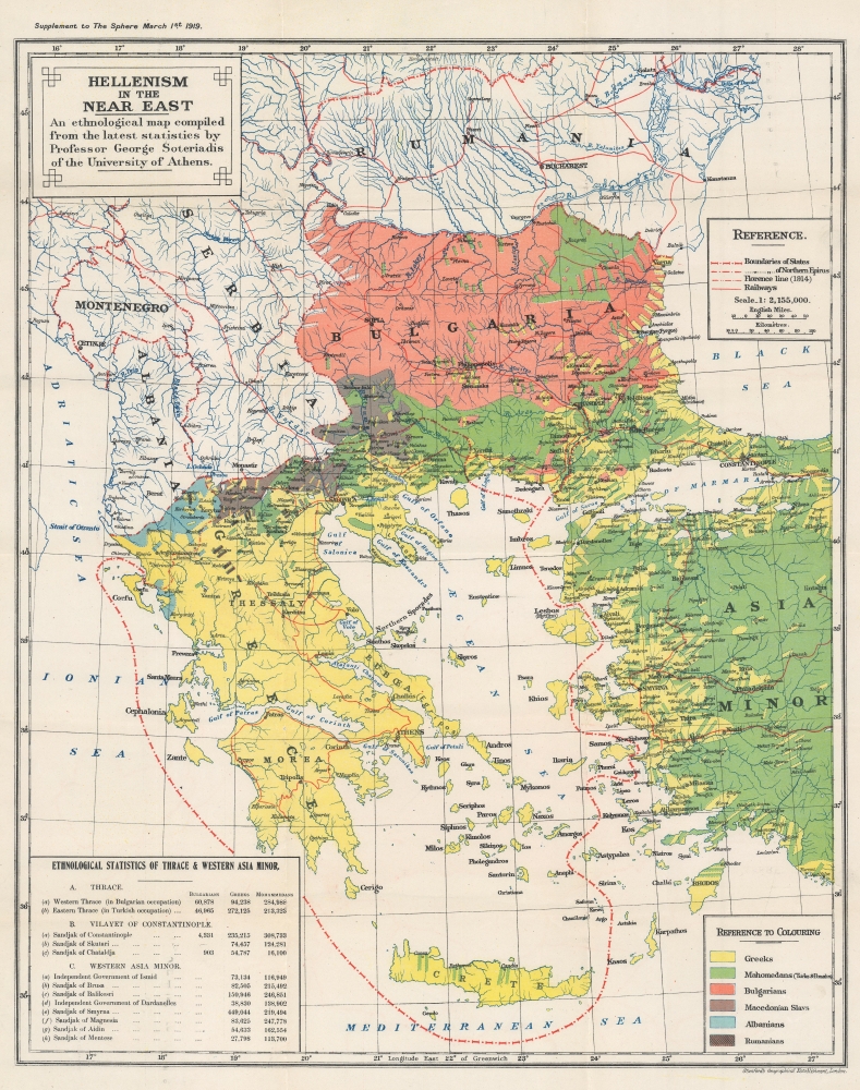
Hellenism in the Near East. An ethological map compiled from the latest statistics by Professor George Soteriadis of the University of Athens.
1919 (dated) 26 x 20.75 in (66.04 x 52.705 cm) 1 : 2155000
1919 (dated) 26 x 20.75 in (66.04 x 52.705 cm) 1 : 2155000
Description
This is a 1919 George Soteriadis ethnological map of the eastern Balkans, Greece, and western Turkey. The map breaks down the ethnic divisions that have long balkanized the Balkans, leading to horrific ethnic clashes in the late 20th century.
A Closer Look
Coverage extends from Romania (Rumania) south to Crete and from the Adriatic Sea east to western Turkey (Asia Minor). Soteriadis uses color to highlight various ethnic groups. A key situated in the lower right explains the map's color-coding. Yellow areas are Greek, while green areas are populated by 'Mahomedans', which Soteriadis further specifies as 'Turks and Pomaks'. 'Pomak', considered derogatory today, was used to describe Bulgarian-speaking Muslims living in Bulgaria, northeastern Greece, and northwestern Turkey. The term has also been used to describe Eastern South Slavic Muslims more generally. Orange identifies Bulgarian-majority zones, while blue highlights Albanian areas. Brown areas reflect populations of 'Macedonian Slavs' and brown with diagonal lines mark 'Rumanians'. A table of ethnological and population statistics occupies the lower left.Northern Epirus and the 'Florence Line'
The name Northern Epirus is mostly used by Greeks to reference parts of the historic region of Epirus that are now part of Albania. The term first appeared in 1913, after the Balkan Wars, following the creation of an independent Albanian state. The Florentine Line is a reference to the Protocol of Florence, part of the 1913 Treaty of London that delineated the boundaries of the new Albanian state. The incorporation of the region (which many Greeks viewed as being culturally, geographically, and historically linked to Greece and the ancient Greek region of Epirus) into Albania created a fervor among the substantial ethnic Greek population in Northern Epirus. These ethnic Greeks declared the Autonomous Republic of Northern Epirus in 1914, which was officially recognized as an autonomous region within Albania by the Protocol of Corfu. When Albania collapsed in July 1914, at the beginning of World War I, the Greek Army occupied Northern Epirus. At the end of the war, even though the Greeks lobbied to annex Northern Epirus, the region reverted to Albanian control. The ethnically driven unrest and violence between the Albanian government and Greek population continued into the 21st century.Publication History and Census
This map was created by George Soteriadis and published as a supplement to the March 1, 1919, edition of The Sphere. A previous edition, published separately by the Stanford Geographical Establishment, was issued in 1918. We note four examples of the present edition in OCLC: the University of Toronto, the National Library of Israel, the University of California Berkeley, and the University of Oxford.CartographerS
George Soteriadis (1852 - 1942) was a professor of history at the University of Athens. In the 1930s, Soteriadis undertook archaeological expeditions in the Marathon region of Greece. More by this mapmaker...
Edward Stanford (May 27, 1827 - November 3, 1904) was one of the most prolific map publishing firms of the late 19th century. The company began as a partnership in 1848 between the 21 year old Edward Stanford and the established map dealer Trelawney Saunders. By 1853 the partnership had dissolved and Edward Stanford took full control of the business. A subsequent series of expansions and exciting new map issues finally led to the production of Stanford's masterwork, "Stanford's Library Map of London". This map is still available and remains somewhat accurate. At the time of publishing it was hailed by the Royal Geographical Society as "the most perfect map of London that has ever been issued". In 1882 Edward Stanford Sr. passed the firm on to his son, Edward Stanford Jr. who continued in his father's proud tradition. Today the Stanford firm still publishes maps and remains one of the most important and prolific cartographic publishers in the world. Learn More...
Source
The Sphere, Supplement, March 1, 1919.
The Sphere (January 27, 1900 - June 27, 1964), formally known as The Sphere: An Illustrated Newspaper for the Home and later The Sphere: The Empire's Illustrated Weekly was a British newspaper. Launched at the height of the Boer War by London Illustrated Newspapers, The Sphere competed directly with two other newspapers: The Graphic and Illustrated London News. The Sphere published news from Britain and around the world, since its target audiece was British subjects living in the colonies. A total of 3,343 issuese were published, plus a special edition published in January 1965 entitled Winston Churchill: A Memorial Tribute. Two institutions, the British Library and the National Library of Scotland, hold copies of the entire print run of the newspaper.
Condition
Very good. Exhibits toning and light wear along original fold lines. Exhibits verso repairs at fold intersections. Exhibits one small area of infill.
References
OCLC 234162568, 43094725.