This item has been sold, but you can get on the Waitlist to be notified if another example becomes available, or purchase a digital scan.
1752 Homann Heirs Map of Switzerland
Helvetia-hmhr-1753$150.00

Title
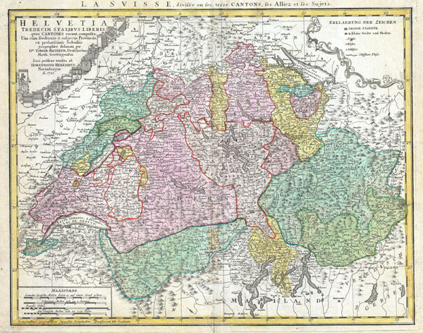
Helvetia Tredecim Statibus Liberis quos Cantones vocant, composita. Unacum feoderatis & subjectis Provinciis, ex porbatissimis Subsidiis geographice delineata per Dm. Tobiam Mayerum, Professorem Matth. Goettingensem.
1752 (dated) 17.25 x 22 in (43.815 x 55.88 cm)
1752 (dated) 17.25 x 22 in (43.815 x 55.88 cm)
Description
A beautifully detailed 1751 Homann Heirs map of Switzerland. Depicts Switzerland along with parts of Italy, France, Germany and Austria. The map notes fortified cities, villages, roads, bridges, forests, castles and topography. Title cartouche in the upper right quadrant features the thirteen armorial crests of Switzerland's noble families. Map scales in the lower left quadrant. Alternative title in French in top margin, above scales La Suisse, divisee en ses treze Cantons, ses Alliez et ses Sujets This map was drawn in Nuremberg by Tobius Mayer and included in the Homann Heirs Maior Atlas Scholasticus ex Triginta Sex Generalibus et Specialibus…. .
Cartographer
Homann Heirs (1730 - 1848) were a map publishing house based in Nuremberg, Germany, in the middle to late 18th century. After the great mapmaker Johann Baptist Homann's (1664 - 1724) death, management of the firm passed to his son Johann Christoph Homann (1703 - 1730). J. C. Homann, perhaps realizing that he would not long survive his father, stipulated in his will that the company would be inherited by his two head managers, Johann Georg Ebersberger (1695 - 1760) and Johann Michael Franz (1700 - 1761), and that it would publish only under the name 'Homann Heirs'. This designation, in various forms (Homannsche Heirs, Heritiers de Homann, Lat Homannianos Herod, Homannschen Erben, etc..) appears on maps from about 1731 onwards. The firm continued to publish maps in ever diminishing quantities until the death of its last owner, Christoph Franz Fembo (1781 - 1848). More by this mapmaker...
Source
Major Atlas Scholasticus Ex Triginta sex Generalibus et Specialibus Mappis Homannianis..., c. 1752.
Condition
Very good condition. Original centerfold with some minor discoloration. Original platemark visible. Minor toning. Blank on verso.