This item has been sold, but you can get on the Waitlist to be notified if another example becomes available, or purchase a digital scan.
1724 Delisle Map of the Western Hemisphere or America
HemisphereOccidental-delisle-1724$375.00

Title
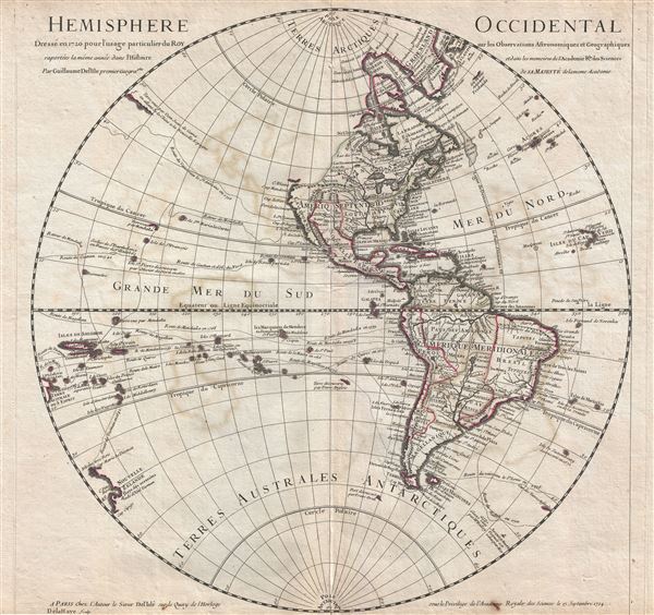
Hemisphere Occidental.
1724 (dated) 19 x 20 in (48.26 x 50.8 cm) 1 : 54000000
1724 (dated) 19 x 20 in (48.26 x 50.8 cm) 1 : 54000000
Description
An attractive 1724 map of the Western Hemisphere, or the Americas by the well-respected French cartographer Guillaume Delisle. Centered on North and South America, this map covers the Western Hemisphere from Pole to Pole and from the New Hebrides Islands to the Cape Verde Islands. Delisle focuses on known shorelines and attempts to avoid positivist speculation, especially with regard to the unexplored reaches of the American Northwest Coast. The routes of prominent explorers including Halley, Quiros, Mendana, La Maire, Olivier de Nord, and Magellan, as well as the ships St. Louis, Gaetan, and St. Antoine.
North America is centered on a massive Louisiana territory, itself focused about the great Mississippi River with its numerous tributaries, most of which flow from the vast unexplored territories north of Mexico (New Spain). The English Colonies are confined to a narrow coastal expanse stretching from Carolina to Boston Bay and extending inland no more than the Appalachian Mountains. Spain's claims on Mexico, here identified as Nouvelle Espagne, are similarly curtailed, with French claims to Louisiana extending westward as far as the Rio Grande (Rio del Norte) - thus including modern day Texas. Spanish claims are further truncated just north of Louisiana, leaving much of California, apparently, and the entire unexplored Northwest up for grabs. The setting here is not far from the truth, the French empire in North America being, during this period, at its apex. The French, through right of discovery conferred by explorers like La Salle and d'Iberville, as well as through trade alliances with various American Indian nations, claimed the Mississippi Valley and all of its tributaries, as well as all five of the Great Lakes and most of modern day Canada with the exception of the immediate vicinity of the Hudson Bay. Spain, with a French king on its throne, did little to contest French ambition in Louisiana, which left even the mineral rich interior of Mexico painfully close to the French border - a fact that would later lead to American claims on Texas and the Mexican American War. The northwestern part of America, still unexplored, is left blank.
In South America, Delisle maps the Laguna de Xarayes as the source of the Paraguay River. The Xarayes, a corruption of 'Xaraies' meaning 'Masters of the River,' were an indigenous people occupying what are today parts of Brazil's Matte Grosso and the Pantanal. When Spanish and Portuguese explorers first navigated up the Paraguay River, as always in search of El Dorado, they encountered the vast Pantanal flood plain at the height of its annual inundation. Understandably misinterpreting the flood plain as a gigantic inland sea, they named it after the local inhabitants, the Xaraies. The Laguna de los Xarayes almost immediately began to appear on early maps of the region and, at the same time, almost immediately took on a legendary aspect. Later missionaries and chroniclers, particularly Díaz de Guzman, imagined an island in this lake and curiously identified it as an 'Island of Paradise,'
Delisle's mapping of the South Pacific offers much of interest, including numerous hard to identify islands associated with the explorations of Mendana in 1595, Quiros in 1605, and Magellan in 1520. Identifiable islands including 'Terre decouverte par Davis Anglois,' which is most likely Easter Island, the Marqueses, and an oversized representation of the Solomon Islands. New Zealand, reflecting the discoveries of Abel Tasman, appears in embryonic form.
Far to the west, at the border of the map itself, is another landmass labeled Terre Australe du S'Espirit, with several rivers but no western shore. Terre Australe du S'Espirit, in fact the New Hebrides, was mis-mapped by the near insane and zealously Catholic 17th century Portuguese navigator Pedro Fernandes de Queiros, who proclaimed that he had discovered the long speculated Great Southern Continent, or Terre Australis. Not to be confused with modern day Australia, Terre Australis was a vast theoretical continent that supposedly covered much of the southern hemisphere in Aristotelian symmetry with the bulk of Asia in the Northern Hemisphere.
Another area of exceptional interest and great speculation are the islands at the northwestern border of the map identified as 'Terre vue par Dom Jean de Gama.' Jean de Gama is a mysterious 17th century Spanish explorer who rumors claim discovered islands rich in gold and silver northeast of Japan - a kind of Asian El Dorado. The Dutch navigators Maerten de Vries and Cornelis Jansz Coen were among the first navigators to sail into this unknown region in search of Gama's islands. Gama as presented here reflects preliminary sightings of the Japanese Kuril Islands in 1643 by de Vries and Coen.
This map was engraved by Delahaye and published by Guillaume Delisle form his offices at Quay de l'Horloge, Paris. The first edition was drawn in 1720. The present example represents and updated and revised edition presented to and approved by the Acadamie Royale des Sciences on the 15th of September, 1724. It proved popular with this and subsequent editions being published and revised throughout the 17th century.
North America is centered on a massive Louisiana territory, itself focused about the great Mississippi River with its numerous tributaries, most of which flow from the vast unexplored territories north of Mexico (New Spain). The English Colonies are confined to a narrow coastal expanse stretching from Carolina to Boston Bay and extending inland no more than the Appalachian Mountains. Spain's claims on Mexico, here identified as Nouvelle Espagne, are similarly curtailed, with French claims to Louisiana extending westward as far as the Rio Grande (Rio del Norte) - thus including modern day Texas. Spanish claims are further truncated just north of Louisiana, leaving much of California, apparently, and the entire unexplored Northwest up for grabs. The setting here is not far from the truth, the French empire in North America being, during this period, at its apex. The French, through right of discovery conferred by explorers like La Salle and d'Iberville, as well as through trade alliances with various American Indian nations, claimed the Mississippi Valley and all of its tributaries, as well as all five of the Great Lakes and most of modern day Canada with the exception of the immediate vicinity of the Hudson Bay. Spain, with a French king on its throne, did little to contest French ambition in Louisiana, which left even the mineral rich interior of Mexico painfully close to the French border - a fact that would later lead to American claims on Texas and the Mexican American War. The northwestern part of America, still unexplored, is left blank.
In South America, Delisle maps the Laguna de Xarayes as the source of the Paraguay River. The Xarayes, a corruption of 'Xaraies' meaning 'Masters of the River,' were an indigenous people occupying what are today parts of Brazil's Matte Grosso and the Pantanal. When Spanish and Portuguese explorers first navigated up the Paraguay River, as always in search of El Dorado, they encountered the vast Pantanal flood plain at the height of its annual inundation. Understandably misinterpreting the flood plain as a gigantic inland sea, they named it after the local inhabitants, the Xaraies. The Laguna de los Xarayes almost immediately began to appear on early maps of the region and, at the same time, almost immediately took on a legendary aspect. Later missionaries and chroniclers, particularly Díaz de Guzman, imagined an island in this lake and curiously identified it as an 'Island of Paradise,'
...an island [of the Paraguay River] more than ten leagues [56 km] long, two or three [11-16 km] wide. A very mild land rich in a thousand types of wild fruit, among them grapes, pears and olives: the Indians created plantations throughout, and throughout the year sow and reap with no difference in winter or summer, ... the Indians of that island are of good will and are friends to the Spaniards; Orejon they call them, and they have their ears pierced with wheels of wood ... which occupy the entire hole. They live in round houses, not as a village, but each apart though keep up with each other in much peace and friendship. They called of old this island Land of Paradise for its abundance and wonderful qualities.To the north of the 'Island of Paradise' appeared the 'Puerto de los Reyes' which was considered to be a gateway to the Amazon and the Kingdom of el Dorado.
Delisle's mapping of the South Pacific offers much of interest, including numerous hard to identify islands associated with the explorations of Mendana in 1595, Quiros in 1605, and Magellan in 1520. Identifiable islands including 'Terre decouverte par Davis Anglois,' which is most likely Easter Island, the Marqueses, and an oversized representation of the Solomon Islands. New Zealand, reflecting the discoveries of Abel Tasman, appears in embryonic form.
Far to the west, at the border of the map itself, is another landmass labeled Terre Australe du S'Espirit, with several rivers but no western shore. Terre Australe du S'Espirit, in fact the New Hebrides, was mis-mapped by the near insane and zealously Catholic 17th century Portuguese navigator Pedro Fernandes de Queiros, who proclaimed that he had discovered the long speculated Great Southern Continent, or Terre Australis. Not to be confused with modern day Australia, Terre Australis was a vast theoretical continent that supposedly covered much of the southern hemisphere in Aristotelian symmetry with the bulk of Asia in the Northern Hemisphere.
Another area of exceptional interest and great speculation are the islands at the northwestern border of the map identified as 'Terre vue par Dom Jean de Gama.' Jean de Gama is a mysterious 17th century Spanish explorer who rumors claim discovered islands rich in gold and silver northeast of Japan - a kind of Asian El Dorado. The Dutch navigators Maerten de Vries and Cornelis Jansz Coen were among the first navigators to sail into this unknown region in search of Gama's islands. Gama as presented here reflects preliminary sightings of the Japanese Kuril Islands in 1643 by de Vries and Coen.
This map was engraved by Delahaye and published by Guillaume Delisle form his offices at Quay de l'Horloge, Paris. The first edition was drawn in 1720. The present example represents and updated and revised edition presented to and approved by the Acadamie Royale des Sciences on the 15th of September, 1724. It proved popular with this and subsequent editions being published and revised throughout the 17th century.
Cartographer
The De L'Isle family (fl. c. 1700 - c. 1760) (also written Delisle) were, in composite, a mapmaking tour de force who redefined early 18th century European cartography. Claude De L'Isle (1644 -1720), the family patriarch, was Paris based a historian and geographer under Nicholas Sanson. De L'Isle and his sons were proponents of the school of "positive geography" and were definitive figures, defining the heights of the Golden Age of French Cartography. Of his twelve sons, four, Guillaume (1675 - 1726), Simon Claude (1675 - 1726), Joseph Nicholas (1688 - 1768) and Louis (1720 - 1745), made a significant contributions to cartography. Without a doubt Guillaume was the most remarkable member of the family. It is said that Guillaume's skill as a cartographer was so prodigious that he drew his first map at just nine years of age. He was tutored by J. D. Cassini in astronomy, science, mathematics and cartography. By applying these diverse disciplines to the vast stores of information provided by 18th century navigators, Guillaume created the technique that came to be known as "scientific cartography", essentially an extension of Sanson's "positive geography". This revolutionary approach transformed the field of cartography and created a more accurate picture of the world. Among Guillaume's many firsts are the first naming of Texas, the first correct map of the Mississippi, the final rejection of the insular California fallacy, and the first identification of the correct longitudes of America. Stylistically De L'Isle also initiated important changes to the medium, eschewing the flamboyant Dutch style of the previous century in favor of a highly detailed yet still decorative approach that yielded map both beautiful and informative. Guillaume was elected to the French Academie Royale des Sciences at 27. Later, in 1718, he was also appointed "Premier Geographe du Roi", an office created especially for him. De L'Isle personally financed the publication of most of his maps, hoping to make heavy royalties on their sales. Unfortunately he met an untimely death in 1728, leaving considerable debt and an impoverished child and widow. De L'Isle's publishing firm was taken over by his assistant, Phillipe Buache who became, posthumously, his son in law. The other De L'Isle brothers, Joseph Nicholas and Louis De L'Isle, were employed in the Service of Peter the Great of Russia as astronomers and surveyors. They are responsible for cataloguing and compiling the data obtained from Russian expeditions in the Pacific and along the northwest coast of America, including the seminal explorations of Vitus Bering and Aleksei Chirikov. The De L'Isles, like their rivals the Vaugondys , must be considered speculative geographers. Speculative geography was a genre of mapmaking that evolved in Europe, particularly Paris, in the middle to late 18th century. Cartographers in this genre would fill in unknown areas on their maps with speculations based upon their vast knowledge of cartography, personal geographical theories, and often dubious primary source material gathered by explorers and navigators. This approach, which attempted to use the known to validate the unknown, naturally engendered many rivalries. The era of speculatively cartography effectively ended with the late 18th century explorations of Captain Cook, Jean Francois de Galaup de La Perouse, and George Vancouver. More by this mapmaker...
Condition
Good. Original centerfold exhibits some wear. Lower and upper margins narrow, but intact. Platemark visible.
References
Rumsey 4638.005.